1940s Maps of Stutsman County, North Dakota
Explore 1 historic maps of Stutsman County from the 1940s. These maps offer a rare glimpse into what life looked like during the 1940s — showing old roads, neighborhoods, homes, and landmarks that have changed or disappeared over time.
Whether you're researching your family's past, planning a metal detecting trip, or studying how Stutsman County's landscape evolved across the 1940s, these high-resolution maps are a powerful tool for exploring the history of this region.
- Focus on a specific era: All maps on this page are from the 1940s, giving you a focused view of this time period.
- See what’s changed: Compare century-old streets, trails, and buildings to today's modern landscape using overlays and satellite layers.
- Research with precision: Use these maps for genealogy, historical research, land use analysis, or educational projects.
- View, download, or print: Maps are fully viewable online in high resolution, and can be downloaded or printed for your own records.
Start exploring Stutsman County's history through authentic maps from the 1940s. This is your window into the past.
Stutsman County, ND maps
(1)- 1948 Map of Carrington
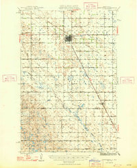 1948 Carrington1948 Print · USGSCarrington and the surrounding Foster County prairies are captured here in the late 1940s at a peak of rail-based agriculture. Genealogists and local historians can locate dozens of numbered country schools, such as School No 1 and School No 4, and trace the path of the Northern Pacific railroad.
End of results
Showing maps 1-1 of 1
Top cities of Stutsman County
- Jamestown historical maps
- Bloom historical maps
- Homer historical maps
- Medina historical maps
- Fried historical maps
- Streeter historical maps
See more
Frequently asked questions
- What are the different types of historical maps available for Stutsman County?
- What is the oldest map of Stutsman County?
- Where can I purchase historical maps of Stutsman County for my home or office?
- Where can I download high-res historical maps of Stutsman County?
- Are there historical topographic maps available for Stutsman County?
- Is there historical aerial imagery available for Stutsman County?
- Where are historical maps of Stutsman County sourced from?