1990s Maps of Stutsman County, North Dakota
Explore 13 historic maps of Stutsman County from the 1990s. These maps offer a rare glimpse into what life looked like during the 1990s — showing old roads, neighborhoods, homes, and landmarks that have changed or disappeared over time.
Whether you're researching your family's past, planning a metal detecting trip, or studying how Stutsman County's landscape evolved across the 1990s, these high-resolution maps are a powerful tool for exploring the history of this region.
- Focus on a specific era: All maps on this page are from the 1990s, giving you a focused view of this time period.
- See what’s changed: Compare century-old streets, trails, and buildings to today's modern landscape using overlays and satellite layers.
- Research with precision: Use these maps for genealogy, historical research, land use analysis, or educational projects.
- View, download, or print: Maps are fully viewable online in high resolution, and can be downloaded or printed for your own records.
Start exploring Stutsman County's history through authentic maps from the 1990s. This is your window into the past.
Stutsman County, ND maps
(13)- 1990 Map of Courtenay NW, 1995 Print
 1990 Courtenay NW1995 Print · USGSStutsman County's prairie landscape is captured here in the 1990s, showcasing a region defined by its conservation areas and rural townships. Genealogists can locate family landmarks like St James Cem and Zion Cem near the banks of Rudolph Lake.
 - 1990 Map of Eldridge NW, 1995 Print
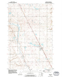
 1990 Eldridge NW1995 Print · USGSStutsman County near the turn of the 1990s remained a landscape of prairie potholes and conservation lands. Genealogists and researchers can trace local hydrology through Deer Lake, Moon Lake, and the National Waterfowl Production Area.
 - 1990 Map of Jamestown, 1995 Print
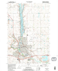 1990 Jamestown1995 Print · USGSJamestown and its surrounding prairie townships are captured here during the mid-nineties as the city expanded along the river forks. Genealogists and researchers can trace family plots in Jamestown Cem, explore the Jamestown College campus, or locate the historic Ft Seward Historic Site.
 - 1990 Map of Jim Lake, 1995 Print
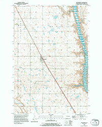
 1990 Jim Lake1995 Print · USGSThe James River valley of Stutsman County is shown here in the 1990s, centered on the vital wetland habitats of the Arrowwood National Wildlife Refuge. Researchers can trace the water levels and boundaries of Jim Lake, Mud Lake, and the surrounding Grasshopper Hills.
 - 1990 Map of Pingree SW, 1995 Print
 1990 Pingree SW1995 Print · USGSStutsman County's glaciated prairie is documented here as it appeared in the early nineties, showing a landscape defined by seasonal wetlands and the winding path of Pipestem Creek. Researchers can identify specific landform markers like Round Top and the Gaging Station used for water monitoring.
 - 1990 Map of Fried, 1995 Print
 1990 Fried1995 Print · USGSStutsman County in the 1990s showcases a landscape of prairie potholes and reservoirs during a period of transition for rural agricultural hubs. Genealogists and local historians can locate the Fried Cem and the settlement of Fried, or trace the shoreline of the Jamestown Reservoir.
 - 1990 Map of Eldridge SE, 1995 Print
 1990 Eldridge SE1995 Print · USGSStutsman County prairie lands are documented here in the final decade of the twentieth century, showing a landscape of townships and protected wetlands. Trace the winding course of Beaver Creek or locate preserved lands within the National Waterfowl Production Area.
 - 1990 Map of Eldridge, 1995 Print
 1990 Eldridge1995 Print · USGSStutsman County's prairie landscape comes into focus during the 1990s as modern interstate travel meets historic rail routes. Researchers can trace the rail line of the Minneapolis St Paul and Sault Ste Marie RR and locate the Eldridge Cem near the town of Eldridge.
 - 1990 Map of Homer, 1995 Print
 1990 Homer1995 Print · USGSStutsman County prairie lands are documented here during the 1990s, capturing the rural intersection of four local townships. Genealogists and researchers can trace the State Hospital Cem and the rail-oriented sites of Jamestown Junction and Kloze.
 - 1990 Map of Buchanan, 1995 Print
 1990 Buchanan1995 Print · USGSThe North Dakota prairie near Buchanan is captured here in the final decade of the twentieth century, showing a landscape of small wetlands and organized agriculture. Researchers can trace the local Cem and the eastern reach of the James River Reservoir.
 - 1991 Map of Pingree, 1995 Print
 1991 Pingree1995 Print · USGSThe rural landscapes of Stutsman County are captured here in the early nineties, showcasing the agricultural heart of central North Dakota. Genealogists can locate family landmarks such as Rest Cem and Cem, or trace the course of Pipestem Creek through Edmunds and Pingree.
 - 1991 Map of Eldridge SW, 1995 Print
 1991 Eldridge SW1995 Print · USGSStutsman County at the start of the 1990s reveals a prairie landscape defined by conservation and water. Local researchers can trace the boundaries of Lippert Flats and numerous National Waterfowl Production Areas along Beaver Creek.
 - 1994 Map of Carrington
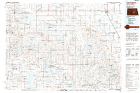 1994 Carrington1994 Print · USGSCentral North Dakota's prairie pothole region comes alive in this mid-nineties survey, showing a landscape defined by expansive wetlands and small rail towns. Genealogists and researchers can trace the vicinity of Carrington and Sykeston, or locate remote landmarks like the Chase Lake National Wildlife Refuge and Lake Williams.
End of results
Showing maps 1-13 of 13
Top cities of Stutsman County
- Jamestown historical maps
- Bloom historical maps
- Homer historical maps
- Medina historical maps
- Fried historical maps
- Streeter historical maps
See more
Frequently asked questions
- What are the different types of historical maps available for Stutsman County?
- What is the oldest map of Stutsman County?
- Where can I purchase historical maps of Stutsman County for my home or office?
- Where can I download high-res historical maps of Stutsman County?
- Are there historical topographic maps available for Stutsman County?
- Is there historical aerial imagery available for Stutsman County?
- Where are historical maps of Stutsman County sourced from?