1940s Maps of Walsh County, North Dakota
Explore 4 historic maps of Walsh County from the 1940s. These maps offer a rare glimpse into what life looked like during the 1940s — showing old roads, neighborhoods, homes, and landmarks that have changed or disappeared over time.
Whether you're researching your family's past, planning a metal detecting trip, or studying how Walsh County's landscape evolved across the 1940s, these high-resolution maps are a powerful tool for exploring the history of this region.
- Focus on a specific era: All maps on this page are from the 1940s, giving you a focused view of this time period.
- See what’s changed: Compare century-old streets, trails, and buildings to today's modern landscape using overlays and satellite layers.
- Research with precision: Use these maps for genealogy, historical research, land use analysis, or educational projects.
- View, download, or print: Maps are fully viewable online in high resolution, and can be downloaded or printed for your own records.
Start exploring Walsh County's history through authentic maps from the 1940s. This is your window into the past.
Walsh County, ND maps
(4)- 1941 Map of Drayton
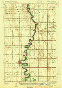 1941 Drayton1941 Print · USGSThe Red River of the North snakes across the border of North Dakota and Minnesota during the late 1930s. Genealogists and historians can trace rail-side towns like Bowesmont and Drayton, or locate rural landmarks such as Skjeberg Ch and the Airway Beacon.2 unique versions available
 - 1941 Map of Glasston
 1941 Glasston1941 Print · USGSThe Red River Valley's agricultural heartland is documented here just before the mid-century, showing a landscape defined by rail-side elevators and rural townships. Researchers can trace family roots through numerous country schools like Quam Sch and landmarks such as the Norwegian Cem near Sugar Siding.
 - 1943 Map of Grafton
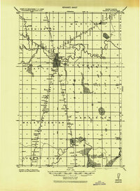 1943 Grafton1943 Print · USGSWalsh County farming communities are caught in transition during this mid-century period as the rail network still dictated local commerce. Genealogists and historians can trace the exact locations of rural Schools, Cemeteries, and early rail stops like Cashel, Voss, and Herriot.
 - 1944 Map of Crystal
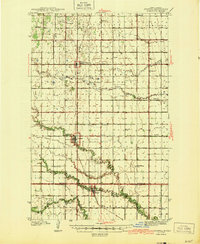 1944 Crystal1944 Print · USGSPembina and Walsh Counties during the early 1940s show a landscape of rail-reliant prairie towns and numerous one-room schoolhouses. Genealogists can locate family-named landmarks like Scheving Sch and Fisher Sch or the rural St Johns Ch.
End of results
Showing maps 1-4 of 4
Top cities of Walsh County
- Grafton historical maps
- Park River historical maps
- Minto historical maps
- Hoople historical maps
- Fordville historical maps
- Edinburg historical maps
See more
Frequently asked questions
- What are the different types of historical maps available for Walsh County?
- What is the oldest map of Walsh County?
- Where can I purchase historical maps of Walsh County for my home or office?
- Where can I download high-res historical maps of Walsh County?
- Are there historical topographic maps available for Walsh County?
- Is there historical aerial imagery available for Walsh County?
- Where are historical maps of Walsh County sourced from?