1960s Maps of Ward County, North Dakota
Explore 2 historic maps of Ward County from the 1960s. These maps offer a rare glimpse into what life looked like during the 1960s — showing old roads, neighborhoods, homes, and landmarks that have changed or disappeared over time.
Whether you're researching your family's past, planning a metal detecting trip, or studying how Ward County's landscape evolved across the 1960s, these high-resolution maps are a powerful tool for exploring the history of this region.
- Focus on a specific era: All maps on this page are from the 1960s, giving you a focused view of this time period.
- See what’s changed: Compare century-old streets, trails, and buildings to today's modern landscape using overlays and satellite layers.
- Research with precision: Use these maps for genealogy, historical research, land use analysis, or educational projects.
- View, download, or print: Maps are fully viewable online in high resolution, and can be downloaded or printed for your own records.
Start exploring Ward County's history through authentic maps from the 1960s. This is your window into the past.
Ward County, ND maps
(2)- 1966 Map of Burlington SE
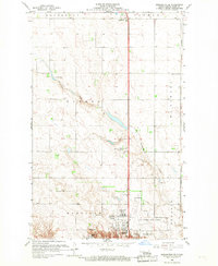 1966 Burlington SE1966 Print · USGSWard County during the mid-sixties shows the steady expansion of northern Minot toward the wide prairie townships. Researchers can trace the development of the Minot International Airport or locate rural landmarks like Ruthville, School No 4, and North Prairie Ch.2 unique versions available
 - 1966 Map of Minot, 1968 Print
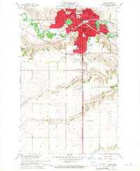 1966 Minot1968 Print · USGSMinot's mid-century development is centered on the Souris River and the crossroads of the Great Northern and Soo Line railroads. Researchers can trace the era's civic growth through Minot State College, local landmarks like Rosehill Cem, and the Agriculture Experimental Station.2 unique versions available
End of results
Showing maps 1-2 of 2
Top cities of Ward County
- Minot historical maps
- Kenmare historical maps
- Burlington historical maps
- Surrey historical maps
- Berthold historical maps
- Sawyer historical maps
See more
Frequently asked questions
- What are the different types of historical maps available for Ward County?
- What is the oldest map of Ward County?
- Where can I purchase historical maps of Ward County for my home or office?
- Where can I download high-res historical maps of Ward County?
- Are there historical topographic maps available for Ward County?
- Is there historical aerial imagery available for Ward County?
- Where are historical maps of Ward County sourced from?