1930s Maps of Belmont County, Ohio
Explore 3 historic maps of Belmont County from the 1930s. These maps offer a rare glimpse into what life looked like during the 1930s — showing old roads, neighborhoods, homes, and landmarks that have changed or disappeared over time.
Whether you're researching your family's past, planning a metal detecting trip, or studying how Belmont County's landscape evolved across the 1930s, these high-resolution maps are a powerful tool for exploring the history of this region.
- Focus on a specific era: All maps on this page are from the 1930s, giving you a focused view of this time period.
- See what’s changed: Compare century-old streets, trails, and buildings to today's modern landscape using overlays and satellite layers.
- Research with precision: Use these maps for genealogy, historical research, land use analysis, or educational projects.
- View, download, or print: Maps are fully viewable online in high resolution, and can be downloaded or printed for your own records.
Start exploring Belmont County's history through authentic maps from the 1930s. This is your window into the past.
Belmont County, OH maps
(3)- 1935 Map of Cameron, 1957 Print
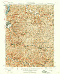 1935 Cameron1957 Print · USGSMarshall County in the mid-thirties was a landscape of deep hollows and high ridges linked by the Baltimore and Ohio RR. Genealogists and historians can locate dozens of country institutions like Wood Hill Ch, Beeler's Station, and Adaline Sch during the era of one-room schoolhouses.2 unique versions available
 - 1935 Map of Clarington, 1957 Print
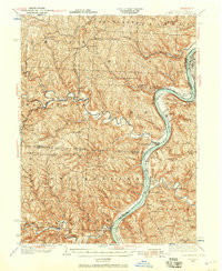 1935 Clarington1957 Print · USGSThe Ohio River valley during the mid-1930s reveals a landscape of ridge-top schools and creek-side coal works. Genealogists can locate family landmarks like McLain Chapel, Centerville Demos P.O., and the Woodland Hill Sch.2 unique versions available
 - 1935 Map of Wheeling, 1957 Print
 1935 Wheeling1957 Print · USGSThe industrial Ohio River valley is captured here in the mid-thirties, showing the complex rail and river networks of the tri-state area. Genealogists can trace family footprints across dozens of rural schools like Wells Sch and local landmarks such as Oglebay Park or the Mt Union Ch.
End of results
Showing maps 1-3 of 3
Top cities of Belmont County
- Martins Ferry historical maps
- St. Clairsville historical maps
- Colerain historical maps
- Barnesville historical maps
- Bellaire historical maps
- Shadyside historical maps
See more
Frequently asked questions
- What are the different types of historical maps available for Belmont County?
- What is the oldest map of Belmont County?
- Where can I purchase historical maps of Belmont County for my home or office?
- Where can I download high-res historical maps of Belmont County?
- Are there historical topographic maps available for Belmont County?
- Is there historical aerial imagery available for Belmont County?
- Where are historical maps of Belmont County sourced from?