1950s Maps of Brown County, Ohio
Explore 11 historic maps of Brown County from the 1950s. These maps offer a rare glimpse into what life looked like during the 1950s — showing old roads, neighborhoods, homes, and landmarks that have changed or disappeared over time.
Whether you're researching your family's past, planning a metal detecting trip, or studying how Brown County's landscape evolved across the 1950s, these high-resolution maps are a powerful tool for exploring the history of this region.
- Focus on a specific era: All maps on this page are from the 1950s, giving you a focused view of this time period.
- See what’s changed: Compare century-old streets, trails, and buildings to today's modern landscape using overlays and satellite layers.
- Research with precision: Use these maps for genealogy, historical research, land use analysis, or educational projects.
- View, download, or print: Maps are fully viewable online in high resolution, and can be downloaded or printed for your own records.
Start exploring Brown County's history through authentic maps from the 1950s. This is your window into the past.
Brown County, OH maps
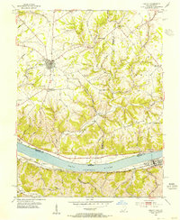
(11)- 1952 Map of Maysville East, 1953 Print
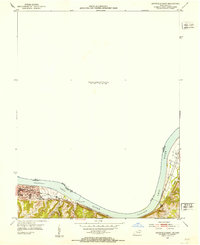 1952 Maysville East1953 Print · USGSThe Ohio River valley near the Mason County line is captured here in the early fifties, showing the vital river-and-rail corridor. Researchers can trace the riverfront development of Maysville or locate landmarks near Sand Hill and the Chesapeake and Ohio railroad.
 - 1952 Map of Higginsport, 1953 Print
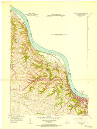
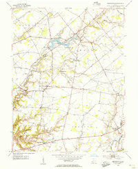
 1952 Higginsport1953 Print · USGSThe Ohio River borderlands of Kentucky and Ohio come into focus in the early 1950s, showing the riverside rail and road networks. Genealogists and local historians can trace family locations near Augusta, Dover, and the Rosemont Cem on the Kentucky shore.
 - 1952 Map of Maysville West, 1953 Print
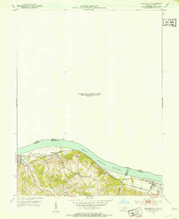
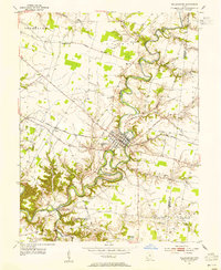
 1952 Maysville West1953 Print · USGSThe Mason County riverfront comes to life in the early 1950s, centered on the historic river town of Maysville and its vital rail connections. Genealogists can trace family footprints near Pleasant Green Ch or follow the old Chesapeake and Ohio line past South Ripley.
 - 1953 Map of Bethel, 1955 Print
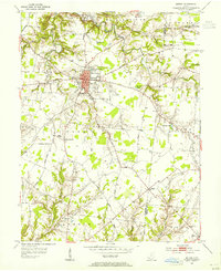 1953 Bethel1955 Print · USGSClermont and Brown County rural life is captured here in the early fifties, centered on the growing village of Bethel. Genealogists can trace family landmarks like Lakin Chapel, Mt Olive, and the Rose Hill Cem near Feesburg.
 - 1953 Map of Felicity, 1955 Print
 1953 Felicity1955 Print · USGSThe Ohio River valley at the mid-century shows the river-and-rail economy of Clermont and Bracken counties. Researchers can trace the Chesapeake and Ohio line through Augusta or locate sites like Utopia, Boudes Ferry, and Mt Zion Ch.2 unique versions available
 - 1953 Map of Newtonsville, 1955 Print
 1953 Newtonsville1955 Print · USGSClermont County's rural landscape is captured here in the early fifties, just as new recreation areas like Stonelick Lake were being established. Local historians can trace the foundations of old crossroads settlements like Newtonsville, Edenton, and Pringle Corners, alongside numerous family burial grounds including Monterey Cem.2 unique versions available
 - 1953 Map of Williamsburg, 1955 Print
 1953 Williamsburg1955 Print · USGSClermont County's rural townships are shown here in the early fifties, centering on the river bends of Williamsburg. Genealogists and researchers can trace family landmarks like Hennings Mills, Alpine Sch, and the Covered Bridge over the river.2 unique versions available
 - 1953 Map of Cincinnati, 1965 Print
 1953 Cincinnati1965 Print · USGSThe Ohio River valley and the industrial heartland of Indiana and Ohio are captured here during the mid-century peak of rail and river commerce. Genealogists and historians can trace connections between Cincinnati and outlying military sites like Camp Atterbury and Bakalar AFB.3 unique versions available
 - 1956 Map of Louisville, 1971 Print
 1956 Louisville1971 Print · USGSThe Ohio River valley and the Kentucky Bluegrass are captured here during a period of rapid mid-century growth and industrial activity. Genealogists and historians can trace rail-centered towns and military land use at Fort Knox and the Jefferson Proving Ground.2 unique versions available
 - 1957 Map of Cincinnati
 1957 Cincinnati1957 Print · USGSThe Ohio River valley and its surrounding highlands thrived during the mid-fifties industrial peak, centered on the bustling Cincinnati and Dayton metropolitan hubs. Researchers can trace the extensive rail networks and military sites like Wright-Patterson AFB and Camp Atterbury.
 - 1957 Map of Huntington, 1966 Print
 1957 Huntington1966 Print · USGSThe industrial heart of the Ohio River valley is captured here in the mid-sixties, showing the growth of Huntington and Ashland. Researchers can trace the extensive rail networks of the Chesapeake and Ohio RR and locate sites like the Chief Cornstalk Hunting Ground.3 unique versions available
End of results
Showing maps 1-11 of 11
Top cities of Brown County
- Georgetown historical maps
- Mount Orab historical maps
- Ripley historical maps
- Aberdeen historical maps
- Sardinia historical maps
- Russellville historical maps
See more
Frequently asked questions
- What are the different types of historical maps available for Brown County?
- What is the oldest map of Brown County?
- Where can I purchase historical maps of Brown County for my home or office?
- Where can I download high-res historical maps of Brown County?
- Are there historical topographic maps available for Brown County?
- Is there historical aerial imagery available for Brown County?
- Where are historical maps of Brown County sourced from?