1960s Maps of Brown County, Ohio
Explore 23 historic maps of Brown County from the 1960s. These maps offer a rare glimpse into what life looked like during the 1960s — showing old roads, neighborhoods, homes, and landmarks that have changed or disappeared over time.
Whether you're researching your family's past, planning a metal detecting trip, or studying how Brown County's landscape evolved across the 1960s, these high-resolution maps are a powerful tool for exploring the history of this region.
- Focus on a specific era: All maps on this page are from the 1960s, giving you a focused view of this time period.
- See what’s changed: Compare century-old streets, trails, and buildings to today's modern landscape using overlays and satellite layers.
- Research with precision: Use these maps for genealogy, historical research, land use analysis, or educational projects.
- View, download, or print: Maps are fully viewable online in high resolution, and can be downloaded or printed for your own records.
Start exploring Brown County's history through authentic maps from the 1960s. This is your window into the past.
Brown County, OH maps
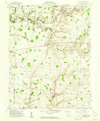
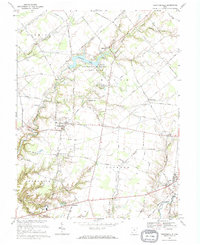
(23)- 1960 Map of Huntington
 1960 Huntington1960 Print · USGSThe tri-state river valley thrived in the late fifties as a hub of heavy industry and Appalachian rail transit. Genealogists and historians can trace the connection between river towns like Ashland and Portsmouth or locate family homesteads near Coleman Ridge.
 - 1960 Map of Lynchburg, 1962 Print
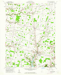
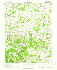
 1960 Lynchburg1962 Print · USGSHighland and Clinton counties are shown at the start of the 1960s, documenting a landscape of rural schoolhouses and family cemeteries within the Virginia Military District. Researchers can trace the path of the Baltimore and Ohio railroad through Lynchburg or locate rural landmarks like Salem Sch and Stroup Cem.3 unique versions available
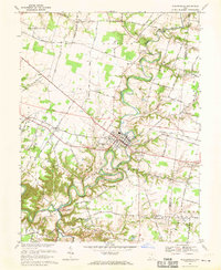
 - 1960 Map of Mount Orab, 1962 Print
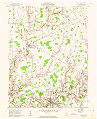
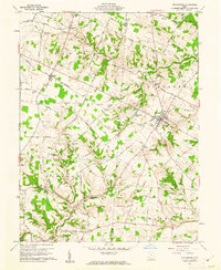
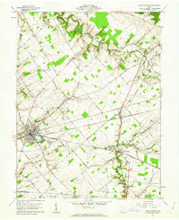
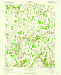
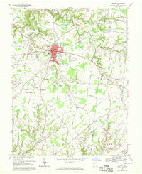
 1960 Mount Orab1962 Print · USGSMount Orab and the surrounding Brown County countryside are captured here in the early sixties as the village grew around the Norfolk and Western rail line. Researchers can trace numerous family-named roads and rural sites like Taylors Chapel, Liberty Chapel, and the southern waters of Lake Grant.4 unique versions available
 - 1960 Map of Hamersville, 1962 Print
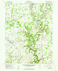 1960 Hamersville1962 Print · USGSBrown County farmland and the deep valley of White Oak Creek define this rural landscape during the early sixties. Researchers can trace the Old R R Grade and locate family burial sites at Warner Cem or Hamersville Cem.2 unique versions available
 - 1960 Map of Fayetteville, 1962 Print
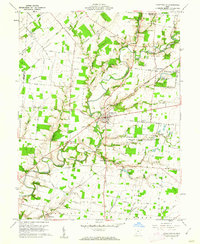 1960 Fayetteville1962 Print · USGSBrown County in the early sixties remains a landscape of traditional farming communities and religious institutions. Genealogists can trace family names at Engle Cem or Dunham Cem and explore the grounds of the Ursuline School for Girls.2 unique versions available
 - 1961 Map of Columbus
 1961 Columbus1961 Print · USGSCentral and Southern Ohio are captured here in the early sixties, as the region's industrial rail hubs and military bases reached their peak. Genealogists and historians can trace the transition from urban Columbus to rural townships along the Scioto River, locating Lockbourne USAF and old junctions like Washington Court House.
 - 1961 Map of Sardinia, 1962 Print
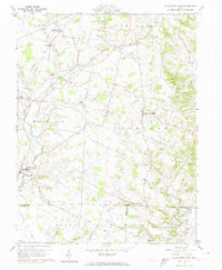
 1961 Sardinia1962 Print · USGSThe rural border of Brown and Highland counties comes into sharp focus during the early sixties, centered on the railroad hub at Sardinia. Researchers can trace old family lines through sites like Hollowtown Cem and locate industrial remnants like the Brickkilns near Mowrystown.4 unique versions available
 - 1961 Map of Winchester, 1962 Print
 1961 Winchester1962 Print · USGSThe rural landscape of Adams and Brown Counties comes into focus in the early sixties, centered on the railroad hub of Winchester. Researchers can trace old family lineages through Memorial Park Cemetery, Independence Cem, and the historic Mt Olivet Ch.3 unique versions available
 - 1961 Map of Blanchester, 1962 Print
 1961 Blanchester1962 Print · USGSClinton County’s railroad heritage is on full display during the early sixties, centered on the bustling junction at Blanchester. Genealogists and local historians can trace family farmsteads along Nauvoo Road and locate historic burial sites like Rehoboth Cem or the IOOF Cem.4 unique versions available
 - 1961 Map of Sugar Tree Ridge, 1962 Print
 1961 Sugar Tree Ridge1962 Print · USGSSouthern Highland County in the early sixties maintains its character as a region of traditional family farms and creek-side settlements. Genealogists can trace decades of local history through sites like East Danville, Mowrystown, and many small family plots like Wilkin Cem.4 unique versions available
 - 1961 Map of Ash Ridge, 1962 Print
 1961 Ash Ridge1962 Print · USGSSouthern Ohio's agricultural and creek-carved landscape is shown here in the early sixties, centered on the crossroads of Arnheim and Ash Ridge. Genealogists can trace numerous family burial grounds and country churches like Biehn Ch, St Marys Cem, and Mt Carmel Cem.3 unique versions available
 - 1961 Map of Maysville East, 1963 Print
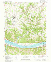
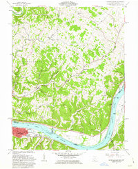 1961 Maysville East1963 Print · USGSThe Ohio River valley and the Kentucky-Ohio border come into focus in this early 1960s survey. Genealogists can trace local roots through numerous family and church landmarks like Hiett Chapel Cem, Ravenscroft Chapel, and the community at Beetle.4 unique versions available
 - 1961 Map of Maysville West, 1963 Print
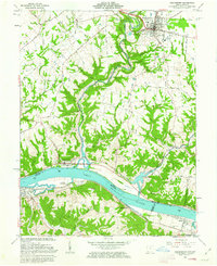
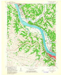 1961 Maysville West1963 Print · USGSThe Ohio River dominates this early 1960s landscape, connecting the bustling riverfront of Maysville with the quiet ridges of Union. Genealogists can trace family names through Maplewood Cem, Fitchs Chapel Cem, and the Lawrence Creek Ch.4 unique versions available
 - 1961 Map of Russellville, 1963 Print
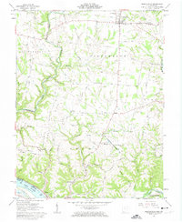 1961 Russellville1963 Print · USGSBrown County, Ohio, is captured in the early sixties as a landscape of ridge-top farms and deep creek hollows. Genealogists can trace family footprints at Linwood Cem and the John Rankin Home, or locate rural landmarks like the Covered Bridge and Redoak Ch.3 unique versions available
 - 1961 Map of Decatur, 1963 Print
 1961 Decatur1963 Print · USGSThe Adams County countryside comes into focus in the early sixties, centered on the village of Decatur and the winding Eagle Creek. Genealogists and historians can locate rural landmarks like Bethlehem Ch, the Covered Bridge, and old family plots at Bissinger Cem.2 unique versions available
 - 1961 Map of Higginsport, 1963 Print
 1961 Higginsport1963 Print · USGSThe Ohio River corridor comes alive in the early sixties as it winds between the riverfront communities of Higginsport, Augusta, and Dover. Researchers can trace the Chesapeake and Ohio rail line, rural family cemeteries like Sallee Cemetery, and the civic layout of Georgetown.3 unique versions available
 - 1962 Map of Columbus
 1962 Columbus1962 Print · USGSCentral Ohio during the early sixties reveals a transition from the industrial corridors of Columbus to the forested ridges of the south. Genealogists and historians can trace the rail networks of the Baltimore & Ohio RR and find local landmarks like Washington Court House and Camp Sherman Military Reservation.
 - 1964 Map of Louisville
 1964 Louisville1964 Print · USGSThe Ohio River valley and Kentucky Bluegrass are captured in the mid-1960s, showing a region balanced between industrial growth and its agrarian roots. Genealogists and historians can trace the development of county seats like Shelbyville and Paris, or locate established institutions such as Georgetown College and Bernheim Forest.
 - 1967 Map of Columbus, 1969 Print
 1967 Columbus1969 Print · USGSCentral Ohio during the late sixties serves as a vital corridor of rail and aviation, from the industrial streets of Springfield to the hangar lines of Lockbourne Air Force Base. Genealogists and researchers can trace the growth of towns like Circleville and London or locate rural landmarks such as St Paul church and the London Correctional Institution.2 unique versions available
 - 1968 Map of Felicity, 1970 Print
 1968 Felicity1970 Print · USGSThe Ohio River valley and the rural uplands of Clermont and Bracken counties are captured here in the late sixties. Trace the riverside rail lines of the Chesapeake and Ohio or locate historic landmarks like Boude Ferry, Utopia, and Mt Zion Ch.2 unique versions available
 - 1968 Map of Bethel, 1970 Print
 1968 Bethel1970 Print · USGSClermont County agriculture and village life are captured here in the late sixties, centered on the bustling hub of Bethel. Local historians can trace the foundations of rural communities like Wiggonsville and Yankeetown or locate family plots at Rose Hill Cem and Brooks Cem.4 unique versions available
 - 1968 Map of Newtonsville, 1970 Print
 1968 Newtonsville1970 Print · USGSThis Clermont County landscape during the late sixties highlights the rural character of southwestern Ohio before significant suburban expansion. Researchers can trace family roots at Shiloh Ch or explore the early layout of Stonelick Lake State Park and Newtonsville.
 - 1968 Map of Williamsburg, 1970 Print
 1968 Williamsburg1970 Print · USGSClermont County and the village of Williamsburg are captured here in the late sixties as new highway corridors began to reshape the rural landscape. Researchers can trace family roots at Williamsburg Cem or locate legacy sites like Hennings Mill and Maple Grove Ch.4 unique versions available
End of results
Showing maps 1-23 of 23
Top cities of Brown County
- Georgetown historical maps
- Mount Orab historical maps
- Ripley historical maps
- Aberdeen historical maps
- Sardinia historical maps
- Russellville historical maps
See more
Frequently asked questions
- What are the different types of historical maps available for Brown County?
- What is the oldest map of Brown County?
- Where can I purchase historical maps of Brown County for my home or office?
- Where can I download high-res historical maps of Brown County?
- Are there historical topographic maps available for Brown County?
- Is there historical aerial imagery available for Brown County?
- Where are historical maps of Brown County sourced from?