1910s Maps of Brown County, Ohio
Explore 7 historic maps of Brown County from the 1910s. These maps offer a rare glimpse into what life looked like during the 1910s — showing old roads, neighborhoods, homes, and landmarks that have changed or disappeared over time.
Whether you're researching your family's past, planning a metal detecting trip, or studying how Brown County's landscape evolved across the 1910s, these high-resolution maps are a powerful tool for exploring the history of this region.
- Focus on a specific era: All maps on this page are from the 1910s, giving you a focused view of this time period.
- See what’s changed: Compare century-old streets, trails, and buildings to today's modern landscape using overlays and satellite layers.
- Research with precision: Use these maps for genealogy, historical research, land use analysis, or educational projects.
- View, download, or print: Maps are fully viewable online in high resolution, and can be downloaded or printed for your own records.
Start exploring Brown County's history through authentic maps from the 1910s. This is your window into the past.
Brown County, OH maps
(7)- 1914 Map of Batavia
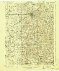
 1914 Batavia1914 Print · USGSClermont County at the start of the Great War shows a landscape connected by steam and electric rail. Genealogists can locate family landmarks like Spread Eagle School, Mt Zion Church, and the winding East Fork Little Miami River.
 - 1915 Map of Maysville, 1962 Print
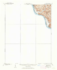 1915 Maysville1962 Print · USGSThe Ohio River valley near the Kentucky border comes to life in this survey from the years before the Great War. Genealogists and local historians can trace rural family-named landmarks like Porter Ridge and remote schoolhouses including Stephenson School and Flaugher School.
 - 1916 Map of Batavia
 1916 Batavia1916 Print · USGSClermont County's river valleys and electric railway networks are frozen in time just before the First World War. Researchers can trace dozens of rural school sites like Zionsville School and follow the old Chillicothe Road through Batavia.4 unique versions available
 - 1917 Map of Hillsboro, 1941 Print
 1917 Hillsboro1941 Print · USGSHighland County during the First World War era was a bustling network of electric rail lines and one-room schoolhouses. Genealogists can locate family landmarks like the Highland County Infirmary or schools such as Kansas College School and Brier College School.2 unique versions available
 - 1917 Map of Sardinia, 1946 Print
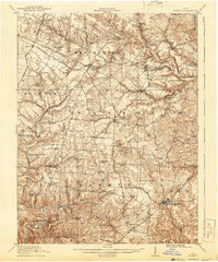
 1917 Sardinia1946 Print · USGSSouthwestern Ohio at the close of the Great War era reveals a landscape of thriving rural schoolhouses and bustling railroad junctions. Genealogists can trace family footprints across dozens of local districts like Richland School or near the Ursuline Convent and Mount Orab.
 - 1918 Map of Seaman, 1943 Print
 1918 Seaman1943 Print · USGSAdams and Brown counties appear in the years following the Great War, showing a landscape defined by small hamlets and the steam-era railroads. Researchers can trace family roots through dozens of rural landmarks like the County Infirmary, Eckmansville, and the Harper Ferry School.
 - 1919 Map of Maysville, 1936 Print
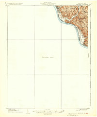 1919 Maysville1936 Print · USGSThe Ohio River bluffs above Ripley were a patchwork of ridge-top farms and rural school districts during the early twentieth century. Researchers can trace the paths of old township roads to find Hawk School, the landing at Aberdeen, and family-named landmarks like Flaugher Ridge.
End of results
Showing maps 1-7 of 7
Top cities of Brown County
- Georgetown historical maps
- Mount Orab historical maps
- Ripley historical maps
- Aberdeen historical maps
- Sardinia historical maps
- Russellville historical maps
See more
Frequently asked questions
- What are the different types of historical maps available for Brown County?
- What is the oldest map of Brown County?
- Where can I purchase historical maps of Brown County for my home or office?
- Where can I download high-res historical maps of Brown County?
- Are there historical topographic maps available for Brown County?
- Is there historical aerial imagery available for Brown County?
- Where are historical maps of Brown County sourced from?