1920s Maps of Brown County, Ohio
Explore 2 historic maps of Brown County from the 1920s. These maps offer a rare glimpse into what life looked like during the 1920s — showing old roads, neighborhoods, homes, and landmarks that have changed or disappeared over time.
Whether you're researching your family's past, planning a metal detecting trip, or studying how Brown County's landscape evolved across the 1920s, these high-resolution maps are a powerful tool for exploring the history of this region.
- Focus on a specific era: All maps on this page are from the 1920s, giving you a focused view of this time period.
- See what’s changed: Compare century-old streets, trails, and buildings to today's modern landscape using overlays and satellite layers.
- Research with precision: Use these maps for genealogy, historical research, land use analysis, or educational projects.
- View, download, or print: Maps are fully viewable online in high resolution, and can be downloaded or printed for your own records.
Start exploring Brown County's history through authentic maps from the 1920s. This is your window into the past.
Brown County, OH maps
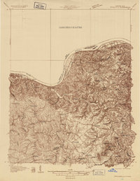
(2)- 1928 Map of Higginsport
 1928 Higginsport1928 Print · USGSThe Kentucky side of the Ohio River is captured in the late twenties just as the rail-and-river economy flourished. Researchers can trace the riverbank rail lines of the Chesapeake and Ohio or locate early rural landmarks like Locust Grove Sch and the town of Augusta.
 - 1929 Map of Springdale
 1929 Springdale1929 Print · USGSThe Ohio River valley and Kentucky's northern hills are captured here in the late twenties, showing a landscape defined by the Chesapeake and Ohio railroad. Genealogists can trace early homesteads and landmarks near Tollesboro, Ruggles Camp, and the many rural sites like Ebenezer Ch.2 unique versions available
End of results
Showing maps 1-2 of 2
Top cities of Brown County
- Georgetown historical maps
- Mount Orab historical maps
- Ripley historical maps
- Aberdeen historical maps
- Sardinia historical maps
- Russellville historical maps
See more
Frequently asked questions
- What are the different types of historical maps available for Brown County?
- What is the oldest map of Brown County?
- Where can I purchase historical maps of Brown County for my home or office?
- Where can I download high-res historical maps of Brown County?
- Are there historical topographic maps available for Brown County?
- Is there historical aerial imagery available for Brown County?
- Where are historical maps of Brown County sourced from?