1960s Maps of Oxford Township, Ohio
Explore 2 historic maps of Oxford Township from the 1960s. These maps offer a rare glimpse into what life looked like during the 1960s — showing old roads, neighborhoods, homes, and landmarks that have changed or disappeared over time.
Whether you're researching your family's past, planning a metal detecting trip, or studying how Oxford Township's landscape evolved across the 1960s, these high-resolution maps are a powerful tool for exploring the history of this region.
- Focus on a specific era: All maps on this page are from the 1960s, giving you a focused view of this time period.
- See what’s changed: Compare century-old streets, trails, and buildings to today's modern landscape using overlays and satellite layers.
- Research with precision: Use these maps for genealogy, historical research, land use analysis, or educational projects.
- View, download, or print: Maps are fully viewable online in high resolution, and can be downloaded or printed for your own records.
Start exploring Oxford Township's history through authentic maps from the 1960s. This is your window into the past.
Oxford Township, OH maps
(2)- 1960 Map of College Corner, 1961 Print
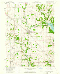 1960 College Corner1961 Print · USGSCollege Corner sits at the crossroads of Indiana and Ohio at the start of the 1960s, a landscape defined by intersecting railroads and state lines. Genealogists can trace family roots through College Corner Cemetery, Hopewell Ch, and the rural settlement of Charlottesville.4 unique versions available
 - 1961 Map of Oxford, 1962 Print
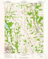 1961 Oxford1962 Print · USGSButler and Preble counties come into focus during the early sixties, showing the expansion of Miami University alongside traditional farmsteads. Researchers can trace the Pennsylvania rail corridor or locate ancestral sites like Beechwood Cem and Morning Sun.4 unique versions available
End of results
Showing maps 1-2 of 2
Top cities near Oxford Township
- Hamilton historical maps
- Fairfield historical maps
- Oxford historical maps
- Forest Park historical maps
- Eaton historical maps
- Ross Township historical maps
See more
Top neighborhoods of Oxford Township
- Contreras historical maps
- Oxford historical maps
- Austin-Magie Farm and Mill Historic District historical maps
Frequently asked questions
- What are the different types of historical maps available for Oxford Township?
- What is the oldest map of Oxford Township?
- Where can I purchase historical maps of Oxford Township for my home or office?
- Where can I download high-res historical maps of Oxford Township?
- Are there historical topographic maps available for Oxford Township?
- Is there historical aerial imagery available for Oxford Township?
- Where are historical maps of Oxford Township sourced from?