1910s Maps of Darke County, Ohio
Explore 8 historic maps of Darke County from the 1910s. These maps offer a rare glimpse into what life looked like during the 1910s — showing old roads, neighborhoods, homes, and landmarks that have changed or disappeared over time.
Whether you're researching your family's past, planning a metal detecting trip, or studying how Darke County's landscape evolved across the 1910s, these high-resolution maps are a powerful tool for exploring the history of this region.
- Focus on a specific era: All maps on this page are from the 1910s, giving you a focused view of this time period.
- See what’s changed: Compare century-old streets, trails, and buildings to today's modern landscape using overlays and satellite layers.
- Research with precision: Use these maps for genealogy, historical research, land use analysis, or educational projects.
- View, download, or print: Maps are fully viewable online in high resolution, and can be downloaded or printed for your own records.
Start exploring Darke County's history through authentic maps from the 1910s. This is your window into the past.
Darke County, OH maps
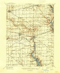
(8)- 1911 Map of Loramie, 1936 Print
 1911 Loramie1936 Print · USGSWestern Ohio at the start of the twentieth century shows a landscape transitioning from the canal era to the age of electric rail. Researchers can trace the Miami and Erie Canal through Minster and New Bremen, or locate family sites near St Patricks Church and Schwaberow School.
 - 1911 Map of Covington, 1946 Print
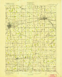
 1911 Covington1946 Print · USGSWestern Ohio’s agricultural heartland is mapped here as a web of turnpikes and railroads connects thriving towns. Trace old family sites near Bradford, Gettysburg, and uniquely named rural landmarks like Lickskillet School or Cassels Corners.
 - 1915 Map of Fort Recovery
 1915 Fort Recovery1915 Print · USGSThe Indiana-Ohio borderlands come into focus during the mid-1910s, showing the agricultural and rail-dependent landscape around Fort Recovery. Genealogists and historians can trace the exact locations of numerous rural institutions like Oak Grove School, Mt Zion School, and the Lake Erie and Western railroad corridor.2 unique versions available
 - 1915 Map of New Paris
 1915 New Paris1915 Print · USGSThe Indiana-Ohio borderlands at the onset of the Great War reveal a landscape of thriving rail hubs and pioneer roads. Genealogists and researchers can trace the early layouts of Hollansburg, Campbellstown, and Sunbeam, or follow the path of the historic National Road.
 - 1916 Map of Winchester
 1916 Winchester1916 Print · USGSIndiana's eastern borderlands during the height of the interurban era show a landscape of thriving rail towns and rural school districts. Genealogists can locate specific landmarks like the County Infirmary, McKinley School, and the cross-border community of Union City.3 unique versions available
 - 1918 Map of Winchester
 1918 Winchester1918 Print · USGSRandolph County sits at a crossroads of major rail lines and headwater streams during the late nineteen-teens. Genealogists can locate dozens of country schoolhouses like McKinley School and Sauerkraut School, or trace family ties in Union City and Lynn.2 unique versions available
 - 1918 Map of Fort Recovery, 1922 Print
 1918 Fort Recovery1922 Print · USGSFort Recovery and the surrounding Mercer County farmsteads are documented here in the early twentieth century, just years after the turn of the century. Genealogists can trace family connections through a high density of rural schoolhouses like Mt Zion School and settlements such as Macedon and Buck Corners.
 - 1918 Map of New Paris, 1922 Print
 1918 New Paris1922 Print · USGSThe Indiana-Ohio border during the First World War reveals a landscape defined by pioneering electric railways and historic transit corridors. Genealogists and historians can trace the growth of New Paris and Hollansburg, or locate small communities like Sunbeam and Cedar Springs.
End of results
Showing maps 1-8 of 8
Top cities of Darke County
- Greenville historical maps
- Versailles historical maps
- Arcanum historical maps
- Union City historical maps
- Ansonia historical maps
- New Madison historical maps
See more
Frequently asked questions
- What are the different types of historical maps available for Darke County?
- What is the oldest map of Darke County?
- Where can I purchase historical maps of Darke County for my home or office?
- Where can I download high-res historical maps of Darke County?
- Are there historical topographic maps available for Darke County?
- Is there historical aerial imagery available for Darke County?
- Where are historical maps of Darke County sourced from?