1940s Maps of Darke County, Ohio
Explore 3 historic maps of Darke County from the 1940s. These maps offer a rare glimpse into what life looked like during the 1940s — showing old roads, neighborhoods, homes, and landmarks that have changed or disappeared over time.
Whether you're researching your family's past, planning a metal detecting trip, or studying how Darke County's landscape evolved across the 1940s, these high-resolution maps are a powerful tool for exploring the history of this region.
- Focus on a specific era: All maps on this page are from the 1940s, giving you a focused view of this time period.
- See what’s changed: Compare century-old streets, trails, and buildings to today's modern landscape using overlays and satellite layers.
- Research with precision: Use these maps for genealogy, historical research, land use analysis, or educational projects.
- View, download, or print: Maps are fully viewable online in high resolution, and can be downloaded or printed for your own records.
Start exploring Darke County's history through authentic maps from the 1940s. This is your window into the past.
Darke County, OH maps
(3)- 1943 Map of Winchester, 1944 Print
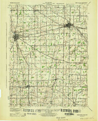 1943 Winchester1944 Print · USGSThe Indiana-Ohio borderlands in the 1940s reveal a landscape of bustling rail junctions and tight-knit rural school districts. Genealogists can trace family footprints at Beech Grove Sch, the County Infirmary, or the curious Sauerkraut Sch.
 - 1944 Map of Covington
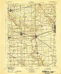 1944 Covington1944 Print · USGSWestern Ohio at the end of the Second World War remains a landscape of thriving rural rail towns and country schoolhouses. Researchers can trace the Stillwater River to find Greenville Falls, the Forest Hill Cem, and local landmarks like Tadpole Sch and Ludlow Falls.
 - 1944 Map of Loramie
 1944 Loramie1944 Print · USGSWest-central Ohio farmland is captured here during the mid-forties, showing the intricate grid of rural school districts and turnpikes. Researchers can trace family-named sites like Fledderjohn Sch and St Patricks Ch near the Loramie Reservoir.
End of results
Showing maps 1-3 of 3
Top cities of Darke County
- Greenville historical maps
- Versailles historical maps
- Arcanum historical maps
- Union City historical maps
- Ansonia historical maps
- New Madison historical maps
See more
Frequently asked questions
- What are the different types of historical maps available for Darke County?
- What is the oldest map of Darke County?
- Where can I purchase historical maps of Darke County for my home or office?
- Where can I download high-res historical maps of Darke County?
- Are there historical topographic maps available for Darke County?
- Is there historical aerial imagery available for Darke County?
- Where are historical maps of Darke County sourced from?