1950s Maps of Fairfield County, Ohio
Explore 6 historic maps of Fairfield County from the 1950s. These maps offer a rare glimpse into what life looked like during the 1950s — showing old roads, neighborhoods, homes, and landmarks that have changed or disappeared over time.
Whether you're researching your family's past, planning a metal detecting trip, or studying how Fairfield County's landscape evolved across the 1950s, these high-resolution maps are a powerful tool for exploring the history of this region.
- Focus on a specific era: All maps on this page are from the 1950s, giving you a focused view of this time period.
- See what’s changed: Compare century-old streets, trails, and buildings to today's modern landscape using overlays and satellite layers.
- Research with precision: Use these maps for genealogy, historical research, land use analysis, or educational projects.
- View, download, or print: Maps are fully viewable online in high resolution, and can be downloaded or printed for your own records.
Start exploring Fairfield County's history through authentic maps from the 1950s. This is your window into the past.
Fairfield County, OH maps
(6)- 1955 Map of Canal Winchester, 1956 Print
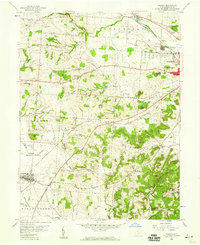
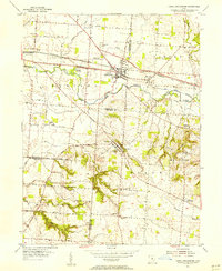 1955 Canal Winchester1956 Print · USGSThe crossroads of Franklin and Fairfield counties are captured here in the mid-fifties, showing the transition from canal-era commerce to a modern rail-and-road network. Genealogists and local historians can locate early landmarks like The Wagnalls Memorial, Township Sch, and Union Grove Cem.
 - 1955 Map of Reynoldsburg, 1956 Print
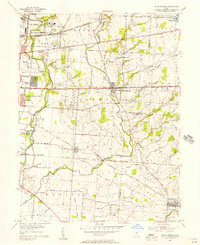 1955 Reynoldsburg1956 Print · USGSThe eastern edges of Columbus and the growing suburbs of Reynoldsburg and Whitehall appear here in the mid-fifties. Genealogists can trace family footprints at Forest Lawn Cemetery or Asbury Ch, while others can find industrial sites like the Claycraft kilns.
 - 1958 Map of Carroll, 1959 Print
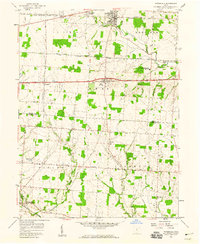
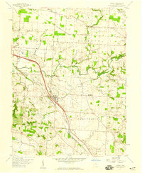 1958 Carroll1959 Print · USGSFairfield County's transportation corridors are frozen in time here, showing the late-1950s transition from rail reliance to modern infrastructure. Researchers can trace family roots at Wildermuth Memorial Ch and Beery Cem or explore the old canal village of Lockville.4 unique versions available
 - 1958 Map of East Ringgold, 1959 Print
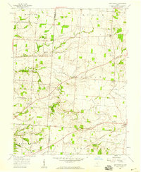 1958 East Ringgold1959 Print · USGSFairfield and Pickaway counties are captured here in the late fifties, showing a rural landscape defined by creek valleys and crossroad hamlets. Researchers can locate family landmarks like Bethany Ch, the East Union Cem, and the rail siding at Amanda.3 unique versions available
 - 1958 Map of Amanda, 1959 Print
 1958 Amanda1959 Print · USGSFairfield County in the late fifties shows a rural landscape where iron rails and abandoned canal beds trace the path of older commerce. Genealogists and researchers can locate numerous family burial grounds and landmarks like Rock Mill, Mt Zion Ch, and the State Industrial Sch.3 unique versions available
 - 1958 Map of Pataskala, 1959 Print
 1958 Pataskala1959 Print · USGSPataskala and Pickerington are shown here in the late fifties, during a period of transition along the National Road. Genealogists can locate family landmarks such as Union Cem, Mt Zion Ch, and the small settlement of Wagram.4 unique versions available
End of results
Showing maps 1-6 of 6
Top cities of Fairfield County
Frequently asked questions
- What are the different types of historical maps available for Fairfield County?
- What is the oldest map of Fairfield County?
- Where can I purchase historical maps of Fairfield County for my home or office?
- Where can I download high-res historical maps of Fairfield County?
- Are there historical topographic maps available for Fairfield County?
- Is there historical aerial imagery available for Fairfield County?
- Where are historical maps of Fairfield County sourced from?