1900-1909 Maps of Fairfield County, Ohio
Explore 7 historic maps of Fairfield County from 1900-1909. These maps offer a rare glimpse into what life looked like during the 1900s — showing old roads, neighborhoods, homes, and landmarks that have changed or disappeared over time.
Whether you're researching your family's past, planning a metal detecting trip, or studying how Fairfield County's landscape evolved across the 1900s, these high-resolution maps are a powerful tool for exploring the history of this region.
- Focus on a specific era: All maps on this page are from the 1900s, giving you a focused view of this time period.
- See what’s changed: Compare century-old streets, trails, and buildings to today's modern landscape using overlays and satellite layers.
- Research with precision: Use these maps for genealogy, historical research, land use analysis, or educational projects.
- View, download, or print: Maps are fully viewable online in high resolution, and can be downloaded or printed for your own records.
Start exploring Fairfield County's history through authentic maps from the 1900s. This is your window into the past.
Fairfield County, OH maps
(7)- 1907 Map of Logan, 1954 Print
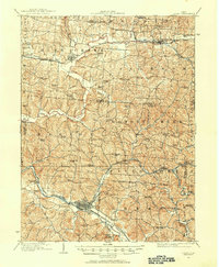 1907 Logan1954 Print · USGSSoutheast Ohio's industrial and rural landscape is captured here during the height of the local iron and rail era. Genealogists and historians can trace family roots through numerous country schools like Nickelplate School and landmarks such as Bessie Furnace or the County Infirmary.2 unique versions available
 - 1907 Map of Lancaster, 1958 Print
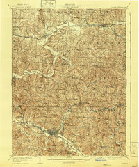
 1907 Lancaster1958 Print · USGSFairfield and Hocking counties are captured here in the early twentieth century, showing a landscape defined by the Hocking River valley and early rail corridors. Researchers can locate vanished landmarks like the Abandoned Hocking Canal and the State Industrial School alongside numerous rural schools and churches.
 - 1907 Map of Thurston, 1960 Print
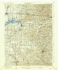
 1907 Thurston1960 Print · USGSFairfield and Licking counties at the turn of the century are shown here as a bustling landscape of rail junctions and early canal segments. Researchers can trace family roots at New Zion Church, locate the Baltimore Campground, or follow the Hocking Canal near Lockville.
 - 1909 Map of Thornville, 1938 Print
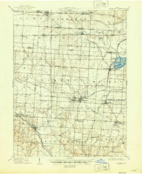
 1909 Thornville1938 Print · USGSLicking, Perry, and Fairfield counties are shown at the turn of the century as the local rail and canal-era economy remained vibrant. Researchers can trace the ancestral locations of numerous rural institutions including Porter School, Fairmount Church, and the Atherton P O at Jacksontown.2 unique versions available
 - 1909 Map of Lancaster, 1938 Print
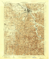 1909 Lancaster1938 Print · USGSFairfield County at the turn of the century shows a bustling rail hub and the remnants of the canal era. Historians can trace the Abandoned Hocking Canal or locate local landmarks like the State Industrial School and Hopewell Church.2 unique versions available
 - 1909 Map of Logan, 1941 Print
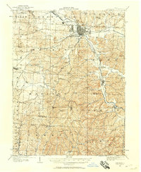
 1909 Logan1941 Print · USGSSoutheastern Ohio at the start of the twentieth century shows a landscape defined by heavy iron works and a complex rail network. Genealogists can locate family-named landmarks like Britain School or Harvey Chapel and trace the lines of the Hocking Valley R. R. through Logan.
 - 1909 Map of Thurston, 1946 Print
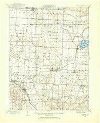
 1909 Thurston1946 Print · USGSCentral Ohio at the start of the twentieth century was a landscape of bustling rail junctions and lakeside retreats. Trace the vanished canal ways and historic rail stops like Lockville, find family landmarks such as Ritter School, or explore the early layout of BUCKEYE LAKE.
End of results
Showing maps 1-7 of 7
Top cities of Fairfield County
Frequently asked questions
- What are the different types of historical maps available for Fairfield County?
- What is the oldest map of Fairfield County?
- Where can I purchase historical maps of Fairfield County for my home or office?
- Where can I download high-res historical maps of Fairfield County?
- Are there historical topographic maps available for Fairfield County?
- Is there historical aerial imagery available for Fairfield County?
- Where are historical maps of Fairfield County sourced from?