1900-1909 Maps of Hancock County, Ohio
Explore 7 historic maps of Hancock County from 1900-1909. These maps offer a rare glimpse into what life looked like during the 1900s — showing old roads, neighborhoods, homes, and landmarks that have changed or disappeared over time.
Whether you're researching your family's past, planning a metal detecting trip, or studying how Hancock County's landscape evolved across the 1900s, these high-resolution maps are a powerful tool for exploring the history of this region.
- Focus on a specific era: All maps on this page are from the 1900s, giving you a focused view of this time period.
- See what’s changed: Compare century-old streets, trails, and buildings to today's modern landscape using overlays and satellite layers.
- Research with precision: Use these maps for genealogy, historical research, land use analysis, or educational projects.
- View, download, or print: Maps are fully viewable online in high resolution, and can be downloaded or printed for your own records.
Start exploring Hancock County's history through authentic maps from the 1900s. This is your window into the past.
Hancock County, OH maps
(7)- 1901 Map of Fostoria, 1958 Print
 1901 Fostoria1958 Print · USGSNorthwest Ohio at the turn of the century is captured here as a thriving rail hub where three counties meet. Genealogists and rail historians can trace the early networks of Fostoria and locate long-standing settlements like New Riegel, Alvada, and Bascom.
 - 1903 Map of Fostoria, 1939 Print
 1903 Fostoria1939 Print · USGSFostoria at the turn of the century was a burgeoning rail center where seven major lines crossed paths at a triple-county border. Genealogists can trace family footprints in small outlying settlements like New Riegel, Bascom, and West Independence or follow the path of the Hocking Valley RR.
 - 1903 Map of Findlay, 1939 Print
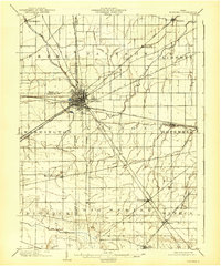
 1903 Findlay1939 Print · USGSNorthwest Ohio at the turn of the century was a powerhouse of rail commerce and early industrial energy. Genealogists and historians can trace the intricate grid of Findlay or find the boom-era roots of Oil Center, Arcadia, and Cygnet.2 unique versions available
 - 1905 Map of Arlington, 1961 Print
 1905 Arlington1961 Print · USGSNorthwest Ohio at the turn of the century was a landscape of dense rail junctions and drainage-fed farmlands. You can trace the intersecting lines of the Northern Ohio RR and Ohio Central Lines at Arlington, or locate rural landmarks like Mt Moriah Church and the Treece School.
 - 1907 Map of Bluffton
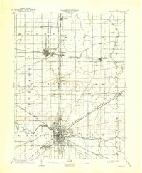
 1907 Bluffton1907 Print · USGSNorthwestern Ohio at the height of the steam and electric rail era shows a landscape of growing college towns and productive farmland. Trace the intersection of the Ohio Northern RR and Lake Erie and Western RR, or find vanished community hubs like Lafayette Herring PO and the Hillsville School.3 unique versions available
 - 1907 Map of Arlington
 1907 Arlington1907 Print · USGSNorthwestern Ohio's fertile landscape is captured here during the peak of its rail-and-river economy. Genealogists can trace family roots through local landmarks like North Washington PO, Jones School, and the Mt Olivet Church.2 unique versions available
 - 1907 Map of Upper Sandusky, 1943 Print
 1907 Upper Sandusky1943 Print · USGSWyandot County at the dawn of the twentieth century was a landscape of thriving rail junctions and dispersed rural school districts. Genealogists and local historians can trace the exact locations of family landmarks like Grace Chapel, the Indian Mill, and numerous rural schools from Moody School to Hendricks School 24.
End of results
Showing maps 1-7 of 7
Top cities of Hancock County
- Findlay historical maps
- McComb historical maps
- Arlington historical maps
- Arcadia historical maps
- Mount Blanchard historical maps
- Vanlue historical maps
See more
Frequently asked questions
- What are the different types of historical maps available for Hancock County?
- What is the oldest map of Hancock County?
- Where can I purchase historical maps of Hancock County for my home or office?
- Where can I download high-res historical maps of Hancock County?
- Are there historical topographic maps available for Hancock County?
- Is there historical aerial imagery available for Hancock County?
- Where are historical maps of Hancock County sourced from?