1960s Maps of Toledo, Ohio
Explore 6 historic maps of Toledo from the 1960s. These maps offer a rare glimpse into what life looked like during the 1960s — showing old roads, neighborhoods, homes, and landmarks that have changed or disappeared over time.
Whether you're researching your family's past, planning a metal detecting trip, or studying how Toledo's landscape evolved across the 1960s, these high-resolution maps are a powerful tool for exploring the history of this region.
- Focus on a specific era: All maps on this page are from the 1960s, giving you a focused view of this time period.
- See what’s changed: Compare century-old streets, trails, and buildings to today's modern landscape using overlays and satellite layers.
- Research with precision: Use these maps for genealogy, historical research, land use analysis, or educational projects.
- View, download, or print: Maps are fully viewable online in high resolution, and can be downloaded or printed for your own records.
Start exploring Toledo's history through authentic maps from the 1960s. This is your window into the past.
Toledo, OH maps
(6)- 1961 Map of Toledo
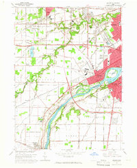
 1961 Toledo1961 Print · USGSThe western basin of Lake Erie and the industrial heart of Northern Ohio are captured here during the post-war era. Researchers can trace historical rail lines like the New York Central or locate landmarks like the Erie Ordnance Depot and Pelee Island.
 - 1964 Map of Maumee, 1965 Print
 1964 Maumee1965 Print · USGSGreater Toledo and the riverfront communities of Maumee and Perrysburg are captured here during a period of mid-century suburban and industrial expansion. Trace the region's frontier roots at Fallen Timbers State Memorial or follow the historic rail paths of the Baltimore and Ohio Railroad.3 unique versions available
 - 1965 Map of Oregon, 1966 Print
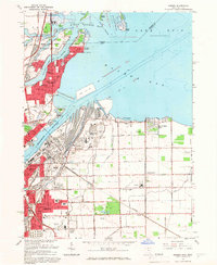 1965 Oregon1966 Print · USGSThe industrial shoreline of Lake Erie comes alive in the mid-sixties, where the heavy rail yards of Toledo meet the growing suburbs of Oregon. Trace family roots at St Ignatius Ch or locate mid-century landmarks like the Drive-in Theater and Clay High Sch.5 unique versions available
 - 1965 Map of Rossford, 1967 Print
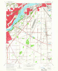 1965 Rossford1967 Print · USGSThe industrial and residential corridors of the Maumee River valley are captured here during the mid-sixties. Local researchers can trace the vast rail yards at Stanley Yard or locate landmarks like the Toledo State Hospital and Eagle Point Cem.3 unique versions available
 - 1965 Map of Sylvania, 1967 Print
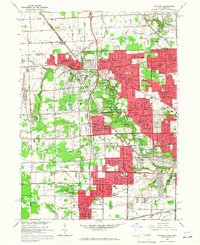 1965 Sylvania1967 Print · USGSGreater Toledo and Sylvania are captured during a period of significant suburban expansion in the mid-1960s. Genealogists and local historians can map out family landmarks like Toledo Memorial Park, St Theresa Ch, and schools from Silica to Ottawa Hills.3 unique versions available
 - 1965 Map of Toledo, 1968 Print
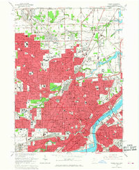 1965 Toledo1968 Print · USGSToledo at the height of its mid-century development shows a landscape defined by the Maumee River and a massive rail network. Genealogists can trace family roots through neighborhood schools like DeVilbiss High Sch and find resting places in Woodlawn Cemetery.4 unique versions available
End of results
Showing maps 1-6 of 6
Top cities near Toledo
- Bedford Township historical maps
- Perrysburg historical maps
- Oregon historical maps
- Sylvania historical maps
- Monroe Charter Township historical maps
- Maumee historical maps
See more
Top neighborhoods of Toledo
- Ironville historical maps
- Shore Acres historical maps
- Air Line Junction historical maps
- Ferndale historical maps
- Fitch historical maps
- Hopewell Heights historical maps
See more
Frequently asked questions
- What are the different types of historical maps available for Toledo?
- What is the oldest map of Toledo?
- Where can I purchase historical maps of Toledo for my home or office?
- Where can I download high-res historical maps of Toledo?
- Are there historical topographic maps available for Toledo?
- Is there historical aerial imagery available for Toledo?
- Where are historical maps of Toledo sourced from?