1930s Maps of Toledo, Ohio
Explore 8 historic maps of Toledo from the 1930s. These maps offer a rare glimpse into what life looked like during the 1930s — showing old roads, neighborhoods, homes, and landmarks that have changed or disappeared over time.
Whether you're researching your family's past, planning a metal detecting trip, or studying how Toledo's landscape evolved across the 1930s, these high-resolution maps are a powerful tool for exploring the history of this region.
- Focus on a specific era: All maps on this page are from the 1930s, giving you a focused view of this time period.
- See what’s changed: Compare century-old streets, trails, and buildings to today's modern landscape using overlays and satellite layers.
- Research with precision: Use these maps for genealogy, historical research, land use analysis, or educational projects.
- View, download, or print: Maps are fully viewable online in high resolution, and can be downloaded or printed for your own records.
Start exploring Toledo's history through authentic maps from the 1930s. This is your window into the past.
Toledo, OH maps
(8)- 1934 Map of Point Place
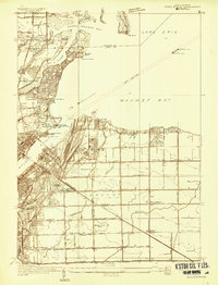 1934 Point Place1934 Print · USGSThe Lake Erie shoreline near Toledo comes to life in the mid-1930s, showing a landscape defined by maritime trade and residential growth. Genealogists and historians can trace family locations near Point Place, Momineetown, and landmarks like the Toledo Yacht Club.
 - 1934 Map of Rossford
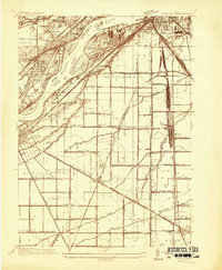 1934 Rossford1934 Print · USGSWood County was a hub of transit and industry in the 1930s, where the Maumee River met a complex web of rail yards and highways. Genealogists can locate family landmarks like Eagle Point Colony, Sunshine Cem, and the old schools at Lark Sch and Glenwood Sch.
 - 1935 Map of Maumee
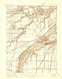 1935 Maumee1935 Print · USGSThe Maumee River valley is shown in the mid-1930s, just as electric railways and state highways began to reshape the old river towns. Genealogists and researchers can locate Springfield Chapel, trace the Cincinnati and Lake Erie line, or find the Hulls Crossing Mill.
 - 1937 Map of Sylvania
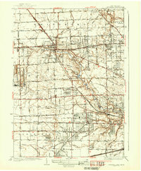 1937 Sylvania1937 Print · USGSSylvania and the Ohio-Michigan borderlands are shown in the mid-1930s as limestone extraction and suburban neighborhoods began to reshape the landscape. Researchers can trace local industry at Medusa Quarry or locate vanished rural landmarks like Dorr St Sch and the Boy Scout Reservation.2 unique versions available
 - 1938 Map of Maumee
 1938 Maumee1938 Print · USGSThe riverfront communities of Northwest Ohio thrive during the mid-1930s as rail and road networks begin to overtake the old canal system. Researchers can trace the legacy of the Miami and Erie Canal and explore historical sites like Fort Meigs and Fallen Timber State Park.2 unique versions available
 - 1938 Map of Toledo
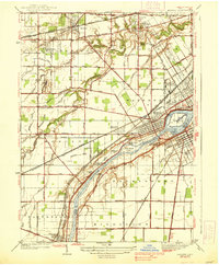
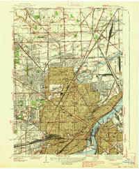 1938 Toledo1938 Print · USGSIn the late thirties, this industrial hub was defined by the confluence of the Maumee River and an immense railroad network. Genealogists and historians can trace the early layout of Toledo University, numerous family cemeteries like Southard Cem, and rail landmarks including Air Line Junction.2 unique versions available
 - 1938 Map of Point Place
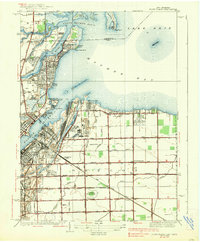 1938 Point Place1938 Print · USGSCoastal life and heavy industry intersect along Maumee Bay in the late thirties as the region’s rail and maritime networks expanded. Researchers can trace the heritage of Point Place, the waterfront Naval Armory, and rural settlements like Momeneetown and Booth.2 unique versions available
 - 1938 Map of Rossford
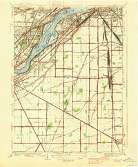 1938 Rossford1938 Print · USGSThe industrial Maumee River valley comes to life in the 1930s, showing a landscape defined by massive rail yards and river islands. Genealogists and local historians can trace the foundations of Eagle Point Colony, the remote Jessie Hill Mission, and old rail hubs like Stanley Yard.
End of results
Showing maps 1-8 of 8
Top cities near Toledo
- Bedford Township historical maps
- Perrysburg historical maps
- Oregon historical maps
- Sylvania historical maps
- Monroe Charter Township historical maps
- Maumee historical maps
See more
Top neighborhoods of Toledo
- Ironville historical maps
- Shore Acres historical maps
- Air Line Junction historical maps
- Ferndale historical maps
- Fitch historical maps
- Hopewell Heights historical maps
See more
Frequently asked questions
- What are the different types of historical maps available for Toledo?
- What is the oldest map of Toledo?
- Where can I purchase historical maps of Toledo for my home or office?
- Where can I download high-res historical maps of Toledo?
- Are there historical topographic maps available for Toledo?
- Is there historical aerial imagery available for Toledo?
- Where are historical maps of Toledo sourced from?