1960s Maps of Waterville, Ohio
Explore 3 historic maps of Waterville from the 1960s. These maps offer a rare glimpse into what life looked like during the 1960s — showing old roads, neighborhoods, homes, and landmarks that have changed or disappeared over time.
Whether you're researching your family's past, planning a metal detecting trip, or studying how Waterville's landscape evolved across the 1960s, these high-resolution maps are a powerful tool for exploring the history of this region.
- Focus on a specific era: All maps on this page are from the 1960s, giving you a focused view of this time period.
- See what’s changed: Compare century-old streets, trails, and buildings to today's modern landscape using overlays and satellite layers.
- Research with precision: Use these maps for genealogy, historical research, land use analysis, or educational projects.
- View, download, or print: Maps are fully viewable online in high resolution, and can be downloaded or printed for your own records.
Start exploring Waterville's history through authentic maps from the 1960s. This is your window into the past.
Waterville, OH maps
(3)- 1961 Map of Toledo
 1961 Toledo1961 Print · USGSThe western basin of Lake Erie and the industrial heart of Northern Ohio are captured here during the post-war era. Researchers can trace historical rail lines like the New York Central or locate landmarks like the Erie Ordnance Depot and Pelee Island.
 - 1964 Map of Maumee, 1965 Print
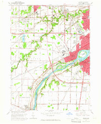 1964 Maumee1965 Print · USGSGreater Toledo and the riverfront communities of Maumee and Perrysburg are captured here during a period of mid-century suburban and industrial expansion. Trace the region's frontier roots at Fallen Timbers State Memorial or follow the historic rail paths of the Baltimore and Ohio Railroad.3 unique versions available
 - 1964 Map of Whitehouse, 1966 Print
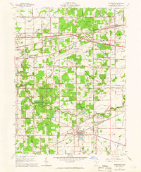 1964 Whitehouse1966 Print · USGSLucas County in the mid-sixties shows a landscape of traditional settlements like Whitehouse and Monclova increasingly defined by modern infrastructure. Researchers can trace the layout of Toledo Express Airport and find local landmarks like Love Lands Ch and the Roth Cem.2 unique versions available
End of results
Showing maps 1-3 of 3
Top cities near Waterville
- Toledo historical maps
- Bowling Green historical maps
- Perrysburg historical maps
- Sylvania historical maps
- Maumee historical maps
- Monclova historical maps
See more
Top neighborhoods of Waterville
Frequently asked questions
- What are the different types of historical maps available for Waterville?
- What is the oldest map of Waterville?
- Where can I purchase historical maps of Waterville for my home or office?
- Where can I download high-res historical maps of Waterville?
- Are there historical topographic maps available for Waterville?
- Is there historical aerial imagery available for Waterville?
- Where are historical maps of Waterville sourced from?