1940s Maps of Waterville, Ohio
Explore 2 historic maps of Waterville from the 1940s. These maps offer a rare glimpse into what life looked like during the 1940s — showing old roads, neighborhoods, homes, and landmarks that have changed or disappeared over time.
Whether you're researching your family's past, planning a metal detecting trip, or studying how Waterville's landscape evolved across the 1940s, these high-resolution maps are a powerful tool for exploring the history of this region.
- Focus on a specific era: All maps on this page are from the 1940s, giving you a focused view of this time period.
- See what’s changed: Compare century-old streets, trails, and buildings to today's modern landscape using overlays and satellite layers.
- Research with precision: Use these maps for genealogy, historical research, land use analysis, or educational projects.
- View, download, or print: Maps are fully viewable online in high resolution, and can be downloaded or printed for your own records.
Start exploring Waterville's history through authentic maps from the 1940s. This is your window into the past.
Waterville, OH maps
(2)- 1940 Map of Whitehouse
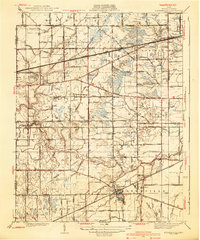 1940 Whitehouse1940 Print · USGSLucas County and the village of Whitehouse are shown here in the mid-1930s as a vital railroad crossroads. Researchers can trace the layout of early schools and cemeteries like Bordner Sch and the Whitehouse Cem, or locate the historic Airway Beacon.2 unique versions available
 - 1940 Map of Grand Rapids
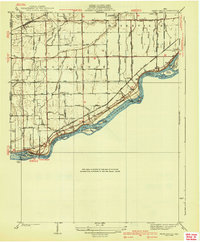 1940 Grand Rapids1940 Print · USGSThe riverfront and rail lines of Wood and Lucas Counties are captured here in the years before WWII. Genealogists and historians can trace the Napoleon Canal, locate Salem Ch, and follow the Twelvemile Reservation Boundary near Grand Rapids.2 unique versions available
End of results
Showing maps 1-2 of 2
Top cities near Waterville
- Toledo historical maps
- Bowling Green historical maps
- Perrysburg historical maps
- Sylvania historical maps
- Maumee historical maps
- Monclova historical maps
See more
Top neighborhoods of Waterville
Frequently asked questions
- What are the different types of historical maps available for Waterville?
- What is the oldest map of Waterville?
- Where can I purchase historical maps of Waterville for my home or office?
- Where can I download high-res historical maps of Waterville?
- Are there historical topographic maps available for Waterville?
- Is there historical aerial imagery available for Waterville?
- Where are historical maps of Waterville sourced from?