1900-1909 Maps of Monroe County, Ohio
Explore 7 historic maps of Monroe County from 1900-1909. These maps offer a rare glimpse into what life looked like during the 1900s — showing old roads, neighborhoods, homes, and landmarks that have changed or disappeared over time.
Whether you're researching your family's past, planning a metal detecting trip, or studying how Monroe County's landscape evolved across the 1900s, these high-resolution maps are a powerful tool for exploring the history of this region.
- Focus on a specific era: All maps on this page are from the 1900s, giving you a focused view of this time period.
- See what’s changed: Compare century-old streets, trails, and buildings to today's modern landscape using overlays and satellite layers.
- Research with precision: Use these maps for genealogy, historical research, land use analysis, or educational projects.
- View, download, or print: Maps are fully viewable online in high resolution, and can be downloaded or printed for your own records.
Start exploring Monroe County's history through authentic maps from the 1900s. This is your window into the past.
Monroe County, OH maps
(7)- 1903 Map of Macksburg, 1958 Print
 1903 Macksburg1958 Print · USGSSoutheast Ohio's river valleys and rail corridors were the lifelines of Noble and Washington counties at the turn of the century. Genealogists can trace family roots through rural post offices like Germantown Saltpeter PO and rail hubs such as Macksburg and Dexter City.
 - 1905 Map of Clarington, 1913 Print
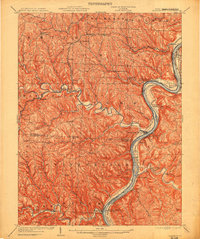 1905 Clarington1913 Print · USGSThe Ohio River valley at the turn of the century shows a bustling corridor of coal mining and rail transport between Ohio and West Virginia. Genealogists can locate family homesteads near Armstrongs Mills, Powhatan Point, and several rural post offices like Welcome P.O.
 - 1905 Map of New Matamoras, 1916 Print
 1905 New Matamoras1916 Print · USGSMonroe and Washington counties come alive in the decade after the century's turn, showing a world of river commerce and ridge-top farming. Genealogists can trace family footprints across old postal stops like Langs P.O. and Centerview P.O. or the milling sites at Rinard Mills.
 - 1905 Map of Woodsfield, 1946 Print
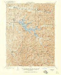
 1905 Woodsfield1946 Print · USGSMonroe and Belmont counties are shown here in the first years of the twentieth century, when the rural landscape was tied together by small postal hubs and creek-side settlements. Genealogists can trace early homesteads near Baileys Mills, Somerton, or Beallsville along the Baltimore and Ohio RR.2 unique versions available
 - 1905 Map of Macksburg, 1948 Print
 1905 Macksburg1948 Print · USGSSoutheastern Ohio at the turn of the century was a landscape of deep creek valleys and rising ridges connected by river and rail. Local historians can trace early post offices like Carlisle Berne P.O. and the winding P. R. R. railroad.
 - 1906 Map of New Martinsville
 1906 New Martinsville1906 Print · USGSThe Ohio River valley at the turn of the century shows a landscape of busy rail lines and riverside towns. You can trace the Baltimore and Ohio railroad through Sistersville or locate early industrial sites like Winders Mill and Porters Falls.2 unique versions available
 - 1909 Map of Summerfield, 1958 Print
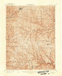
 1909 Summerfield1958 Print · USGSSoutheastern Ohio at the turn of the century reveals a landscape of tight-knit rural communities and a dense network of country schools. Researchers can trace the vanished postal routes of Spencers Sta PO, locate St Johns Church, or study the early rail lines through Quaker City.
End of results
Showing maps 1-7 of 7
Top cities of Monroe County
Frequently asked questions
- What are the different types of historical maps available for Monroe County?
- What is the oldest map of Monroe County?
- Where can I purchase historical maps of Monroe County for my home or office?
- Where can I download high-res historical maps of Monroe County?
- Are there historical topographic maps available for Monroe County?
- Is there historical aerial imagery available for Monroe County?
- Where are historical maps of Monroe County sourced from?