1970s Maps of Monroe County, Ohio
Explore 2 historic maps of Monroe County from the 1970s. These maps offer a rare glimpse into what life looked like during the 1970s — showing old roads, neighborhoods, homes, and landmarks that have changed or disappeared over time.
Whether you're researching your family's past, planning a metal detecting trip, or studying how Monroe County's landscape evolved across the 1970s, these high-resolution maps are a powerful tool for exploring the history of this region.
- Focus on a specific era: All maps on this page are from the 1970s, giving you a focused view of this time period.
- See what’s changed: Compare century-old streets, trails, and buildings to today's modern landscape using overlays and satellite layers.
- Research with precision: Use these maps for genealogy, historical research, land use analysis, or educational projects.
- View, download, or print: Maps are fully viewable online in high resolution, and can be downloaded or printed for your own records.
Start exploring Monroe County's history through authentic maps from the 1970s. This is your window into the past.
Monroe County, OH maps
(2)- 1975 Map of New Matamoras, 1979 Print
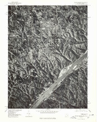 1975 New Matamoras1979 Print · USGSThe Ohio River valley in the mid-seventies is documented here through detailed aerial imagery, showing the relationship between steep river bluffs and rural settlements. Researchers can trace the riverfront layouts of New Matamoras and Grandview or locate the upland community of Brownsville.
 - 1976 Map of Paden City, 1979 Print
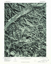 1976 Paden City1979 Print · USGSThe riverfront between West Virginia and Ohio is captured here during the mid-seventies, showing the density of Paden City along the banks. Genealogists and historians can trace property lines and river access near Sardis and Middle Island Creek.
End of results
Showing maps 1-2 of 2
Top cities of Monroe County
Frequently asked questions
- What are the different types of historical maps available for Monroe County?
- What is the oldest map of Monroe County?
- Where can I purchase historical maps of Monroe County for my home or office?
- Where can I download high-res historical maps of Monroe County?
- Are there historical topographic maps available for Monroe County?
- Is there historical aerial imagery available for Monroe County?
- Where are historical maps of Monroe County sourced from?