1900-1909 Maps of Morgan County, Ohio
Explore 7 historic maps of Morgan County from 1900-1909. These maps offer a rare glimpse into what life looked like during the 1900s — showing old roads, neighborhoods, homes, and landmarks that have changed or disappeared over time.
Whether you're researching your family's past, planning a metal detecting trip, or studying how Morgan County's landscape evolved across the 1900s, these high-resolution maps are a powerful tool for exploring the history of this region.
- Focus on a specific era: All maps on this page are from the 1900s, giving you a focused view of this time period.
- See what’s changed: Compare century-old streets, trails, and buildings to today's modern landscape using overlays and satellite layers.
- Research with precision: Use these maps for genealogy, historical research, land use analysis, or educational projects.
- View, download, or print: Maps are fully viewable online in high resolution, and can be downloaded or printed for your own records.
Start exploring Morgan County's history through authentic maps from the 1900s. This is your window into the past.
Morgan County, OH maps
(7)- 1902 Map of Parkersburg
 1902 Parkersburg1902 Print · USGSThe river-and-rail corridor between Ohio and West Virginia comes alive at the dawn of the twentieth century. Researchers can trace the early footprints of Parkersburg and Vienna, the sprawling Blennerhassett Island, and the old rail lines at Belpre.
 - 1903 Map of Athens, 1958 Print
 1903 Athens1958 Print · USGSSoutheast Ohio's Hocking Valley thrives at the height of its coal-mining era, before the shift in regional industry. Researchers can trace historic rail lines like the Electric railway and find vanished company towns such as Orbiston, Buchtel, and Cawthorn.
 - 1904 Map of Parkersburg
 1904 Parkersburg1904 Print · USGSThe riverfront economies of Wood County and Washington County meet at the turn of the century where the Muskingum and Ohio rivers converge. Researchers can trace the early rail networks of the Baltimore and Ohio R.R. and locate family-named settlements like Gravelbank, Center Belpre, and Vincent.5 unique versions available
 - 1904 Map of Chesterhill, 1957 Print
 1904 Chesterhill1957 Print · USGSSoutheast Ohio's rugged hill country is captured here during the peak of its rail-and-river economy in the early twentieth century. Researchers can locate vanished rural post offices and community landmarks like Calvary P O, Bethany Church, and Patten Mills.
 - 1905 Map of Athens
 1905 Athens1905 Print · USGSAthens and the Hocking River valley appear here at the height of the coal and rail era in the early nineteen-hundreds. Genealogists can trace family roots in vanished settlements and industrial junctions like Orbiston, Buchtel, and Marshfield.6 unique versions available
 - 1906 Map of Chesterhill, 1943 Print
 1906 Chesterhill1943 Print · USGSSoutheastern Ohio at the start of the century reveals a landscape of coal-mining hamlets and river valley rail lines. Genealogists and researchers can trace family landmarks like Mills School, Patten Mills, and the scattered post offices of Calvary PO and Federal.
 - 1909 Map of Caldwell, 1956 Print
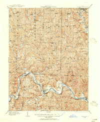 1909 Caldwell1956 Print · USGSThe Muskingum River valley and the hills of Noble and Morgan counties are shown here in the early twentieth century. Genealogists can locate dozens of country institutions, from Bells Church and Manchester Church to the curiously named Beancatcher School and Poochville School.
End of results
Showing maps 1-7 of 7
Top cities of Morgan County
- McConnelsville historical maps
- Malta historical maps
- Stockport historical maps
- Chesterhill historical maps
- Bristol historical maps
Frequently asked questions
- What are the different types of historical maps available for Morgan County?
- What is the oldest map of Morgan County?
- Where can I purchase historical maps of Morgan County for my home or office?
- Where can I download high-res historical maps of Morgan County?
- Are there historical topographic maps available for Morgan County?
- Is there historical aerial imagery available for Morgan County?
- Where are historical maps of Morgan County sourced from?