1960s Maps of Morgan County, Ohio
Explore 22 historic maps of Morgan County from the 1960s. These maps offer a rare glimpse into what life looked like during the 1960s — showing old roads, neighborhoods, homes, and landmarks that have changed or disappeared over time.
Whether you're researching your family's past, planning a metal detecting trip, or studying how Morgan County's landscape evolved across the 1960s, these high-resolution maps are a powerful tool for exploring the history of this region.
- Focus on a specific era: All maps on this page are from the 1960s, giving you a focused view of this time period.
- See what’s changed: Compare century-old streets, trails, and buildings to today's modern landscape using overlays and satellite layers.
- Research with precision: Use these maps for genealogy, historical research, land use analysis, or educational projects.
- View, download, or print: Maps are fully viewable online in high resolution, and can be downloaded or printed for your own records.
Start exploring Morgan County's history through authentic maps from the 1960s. This is your window into the past.
Morgan County, OH maps
(22)- 1960 Map of Watertown, 1961 Print
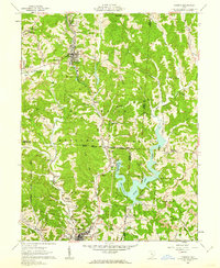
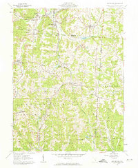
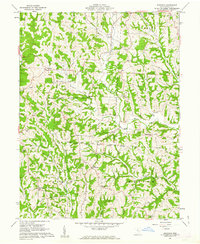
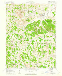
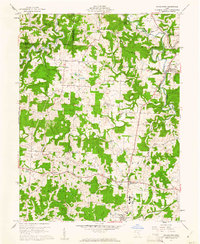 1960 Watertown1961 Print · USGSSoutheastern Ohio's rural landscape is documented here in the early sixties, showing a region defined by agricultural life and active energy extraction. Genealogists can locate family landmarks like Stanley Cemetery, Oak Hill Church, and the schools serving Barlow and Vincent.3 unique versions available
 - 1960 Map of Amesville, 1962 Print
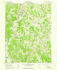
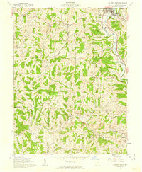
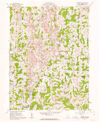
 1960 Amesville1962 Print · USGSSoutheast Ohio’s hill country in the early sixties reveals a landscape transitioning between its mining roots and modern forestry. Genealogists and historians can trace family locations through Mud Sock Cem, Amesville, and the church at Mt Carmel Ch.4 unique versions available
 - 1961 Map of Columbus
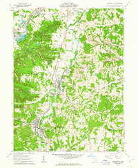
 1961 Columbus1961 Print · USGSCentral and Southern Ohio are captured here in the early sixties, as the region's industrial rail hubs and military bases reached their peak. Genealogists and historians can trace the transition from urban Columbus to rural townships along the Scioto River, locating Lockbourne USAF and old junctions like Washington Court House.
 - 1961 Map of Clarksburg
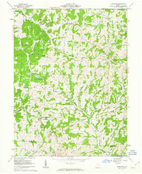
 1961 Clarksburg1961 Print · USGSThe mid-century industrial and river landscapes of West Virginia and Ohio are detailed here, centered on the Ohio River. Researchers can trace the Baltimore and Ohio rail lines connecting towns like Parkersburg, Clarksburg, and Monongah.
 - 1961 Map of Beverly, 1962 Print
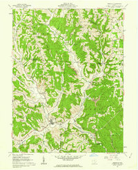
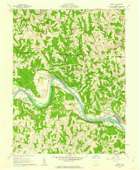
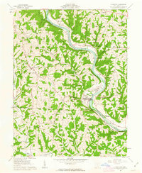
 1961 Beverly1962 Print · USGSThe Muskingum River valley of the early sixties is shown here in detail, from the rail-side hamlets of the Morgan County line to the hubs of Beverly and Waterford. Genealogists can locate family landmarks like Milnor Cem, Smiths Chapel, and the vanished site of Moscow Mills.4 unique versions available
 - 1961 Map of Mc Connelsville, 1962 Print
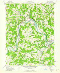
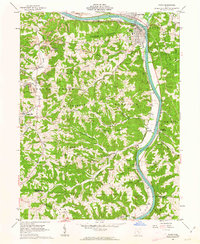
 1961 Mc Connelsville1962 Print · USGSThe riverfront towns of Mc Connelsville and Malta anchor this early 1960s survey of the Muskingum valley. Researchers can trace rural life through McKendree Ch, Jackpot Cem, and the industry of local Strip Mines.4 unique versions available
 - 1961 Map of Corning, 1962 Print
 1961 Corning1962 Print · USGSThe Hocking Valley coal country is captured here in the early sixties as the landscape shifted from mining toward new recreation. Researchers can locate old rail stops along the New York Central Railroad and trace rural roots at Mt Carmel Cem or Spencer Ridge Ch.5 unique versions available
 - 1961 Map of Jacksonville, 1962 Print
 1961 Jacksonville1962 Print · USGSThe coal and rail valleys of Athens County are captured here in the early sixties, showing the busy corridor from Glouster down to Chauncey. Genealogists and local historians can locate family plots at Sands Cem or Brown Cem and trace the old NEW YORK CENTRAL rail line through Millfield.5 unique versions available
 - 1961 Map of Chesterhill, 1962 Print
 1961 Chesterhill1962 Print · USGSMorgan and Washington Counties are shown here in the early 1960s, a landscape of ridge-top farms and valley settlements along the West Branch Wolf Creek. Genealogists and local historians can trace family roots through numerous sites like Chesterhill, Patten Mills, and the Quaker Cem.4 unique versions available
 - 1961 Map of Rokeby Lock, 1962 Print
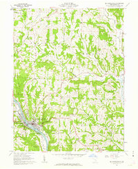
 1961 Rokeby Lock1962 Print · USGSThe Muskingum River valley of southeastern Ohio comes alive in the early sixties, showing a landscape shaped by river navigation and rail. Genealogists can locate family burial sites like Albright Cem and Wiseman Cem or trace vanished landmarks like the Drive-in Theater.4 unique versions available
 - 1961 Map of Deavertown, 1962 Print
 1961 Deavertown1962 Print · USGSSoutheastern Ohio's coal and rail landscape comes into focus during the early sixties, showing the small hamlets and resource hubs of Perry and Morgan counties. Researchers can trace the legacy of industrial settlements like San Toy and Rose Farm alongside local landmarks like Bearfield Sch and Pleasant Grove Ch.6 unique versions available
 - 1961 Map of Caldwell South, 1962 Print
 1961 Caldwell South1962 Print · USGSNoble County in the early sixties is captured here as a landscape of ridge-top cemeteries and deep-valley stream forks. Genealogists and historians can trace family locations near Olive Green and Centerville, or locate rural landmarks like Manchester Ch and Tillsonville Cem.3 unique versions available
 - 1961 Map of Lowell, 1962 Print
 1961 Lowell1962 Print · USGSIn the early 1960s, the Muskingum River valley remained a vital corridor for the Baltimore and Ohio railroad and small riverside communities. Genealogists can trace family lines through numerous sites like Greenlawn Cem, Our Lady of Mercy Ch, and the settlements of Coal Run and Equity.4 unique versions available
 - 1961 Map of Philo, 1963 Print
 1961 Philo1963 Print · USGSThe Muskingum River valley comes alive in the early sixties as a hub of rail transport and resource extraction. Genealogists can locate family burial sites like Irish Ridge Cem or trace the old Baltimore and Ohio Railroad through Philo and Duncan Falls.4 unique versions available
 - 1961 Map of Ringgold, 1963 Print
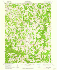
 1961 Ringgold1963 Print · USGSMorgan County in the early sixties remained a landscape of forested ridges and small farm communities shaped by the Ohio Company Purchase. Genealogists and researchers can trace rural life through landmarks like Union-Homer Sch, Pisgah Ch, and the crossroads at Ringgold.4 unique versions available
 - 1961 Map of Reinersville, 1963 Print
 1961 Reinersville1963 Print · USGSMorgan and Noble counties were undergoing a significant industrial shift in the early sixties as large-scale extraction reshaped the rural landscape. Genealogists and local historians can trace small communities and landmarks like Reinersville, Kildow Cem, and Bristol Sch.4 unique versions available
 - 1961 Map of Crooksville, 1963 Print
 1961 Crooksville1963 Print · USGSSoutheastern Ohio at the start of the sixties is captured here as a bustling industrial landscape of rail lines and extraction sites. You can trace the development of the Pennsylvania railroad through Roseville or locate family roots near Rose Hill Cem and Ebenezer Ch.5 unique versions available
 - 1961 Map of Ruraldale, 1963 Print
 1961 Ruraldale1963 Print · USGSMuskingum and Morgan counties are shown in the early sixties, a time when small rural settlements like Ruraldale and Museville were deeply tied to the land. Genealogists and historians can trace family locations through numerous landmarks, including Bethlehem Cem, Sugar Grove Chapel, and the Blue Rock Lookout Tower.4 unique versions available
 - 1961 Map of Cumberland, 1963 Print
 1961 Cumberland1963 Print · USGSSoutheastern Ohio's hill country is captured here during the early sixties, showing a landscape defined by rail transport and surface mining. Trace the Baltimore and Ohio tracks through Cumberland or locate family sites like Brookfield Cem and Ark Springs Ch.4 unique versions available
 - 1961 Map of Stockport, 1963 Print
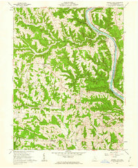
 1961 Stockport1963 Print · USGSThe Muskingum River valley in the early 1960s serves as a backdrop for historic land boundaries and riverfront industry. Genealogists can trace family footprints at Friends Burial Ground, Hopewell Ch, and the Big Bottom State Memorial Park.3 unique versions available
 - 1962 Map of Columbus
 1962 Columbus1962 Print · USGSCentral Ohio during the early sixties reveals a transition from the industrial corridors of Columbus to the forested ridges of the south. Genealogists and historians can trace the rail networks of the Baltimore & Ohio RR and find local landmarks like Washington Court House and Camp Sherman Military Reservation.
 - 1967 Map of Columbus, 1969 Print
 1967 Columbus1969 Print · USGSCentral Ohio during the late sixties serves as a vital corridor of rail and aviation, from the industrial streets of Springfield to the hangar lines of Lockbourne Air Force Base. Genealogists and researchers can trace the growth of towns like Circleville and London or locate rural landmarks such as St Paul church and the London Correctional Institution.2 unique versions available
End of results
Showing maps 1-22 of 22
Top cities of Morgan County
- McConnelsville historical maps
- Malta historical maps
- Stockport historical maps
- Chesterhill historical maps
- Bristol historical maps
Frequently asked questions
- What are the different types of historical maps available for Morgan County?
- What is the oldest map of Morgan County?
- Where can I purchase historical maps of Morgan County for my home or office?
- Where can I download high-res historical maps of Morgan County?
- Are there historical topographic maps available for Morgan County?
- Is there historical aerial imagery available for Morgan County?
- Where are historical maps of Morgan County sourced from?