1910s Maps of Morgan County, Ohio
Explore 6 historic maps of Morgan County from the 1910s. These maps offer a rare glimpse into what life looked like during the 1910s — showing old roads, neighborhoods, homes, and landmarks that have changed or disappeared over time.
Whether you're researching your family's past, planning a metal detecting trip, or studying how Morgan County's landscape evolved across the 1910s, these high-resolution maps are a powerful tool for exploring the history of this region.
- Focus on a specific era: All maps on this page are from the 1910s, giving you a focused view of this time period.
- See what’s changed: Compare century-old streets, trails, and buildings to today's modern landscape using overlays and satellite layers.
- Research with precision: Use these maps for genealogy, historical research, land use analysis, or educational projects.
- View, download, or print: Maps are fully viewable online in high resolution, and can be downloaded or printed for your own records.
Start exploring Morgan County's history through authentic maps from the 1910s. This is your window into the past.
Morgan County, OH maps
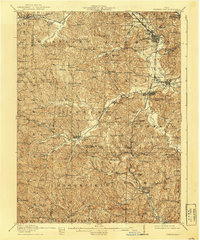
(6)- 1910 Map of Philo, 1938 Print
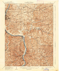 1910 Philo1938 Print · USGSThe Muskingum River valley was a bustling corridor of rail and river commerce at the turn of the century. Genealogists can locate dozens of country schoolhouses like Toadtown School and Sleepy Hollow School, or trace family roots near Taylorsville and the National Road.2 unique versions available
 - 1910 Map of Zanesville, 1939 Print
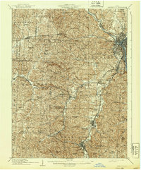 1910 Zanesville1939 Print · USGSMuskingum and Perry counties are shown here in the early twentieth century as Zanesville emerged as a powerhouse of rail and river commerce. Researchers can trace historic transport routes like the National Road or locate local landmarks such as Moxahala Park and the Fultonham (Axline PO).2 unique versions available
 - 1910 Map of Mc Connelsville, 1948 Print
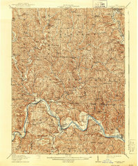
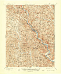 1910 Mc Connelsville1948 Print · USGSAlong the Muskingum River in the early 1900s, river navigation and rural commerce define the landscape. Genealogists can trace family roots through numerous country schools and churches like Mt Carmel Church and Rokeby Lock.
 - 1911 Map of New Lexington, 1939 Print
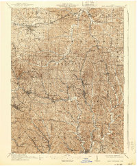 1911 New Lexington1939 Print · USGSPerry County and its neighbors hummed with industrial activity when this survey was conducted. Local researchers can trace old rail lines and family-linked landmarks from St Aloysius Academy down to the mining hubs of Shawnee and New Straitsville.2 unique versions available
 - 1911 Map of Cumberland, 1939 Print
 1911 Cumberland1939 Print · USGSSoutheastern Ohio at the start of the twentieth century was a landscape of ridge-top schools and valley rail junctions. Genealogists can trace family footprints through dozens of rural landmarks like Goshen Church, Dogtown, and the Rough and Ready School.2 unique versions available
 - 1912 Map of Caldwell, 1943 Print
 1912 Caldwell1943 Print · USGSSoutheast Ohio's river valleys and ridge-top settlements are captured here in the years before the Great War. Genealogists can trace family footprints across dozens of rural landmarks, from Manchester Church to the curiously named Poochville School and Valleyburg Woodgrove PO.
End of results
Showing maps 1-6 of 6
Top cities of Morgan County
- McConnelsville historical maps
- Malta historical maps
- Stockport historical maps
- Chesterhill historical maps
- Bristol historical maps
Frequently asked questions
- What are the different types of historical maps available for Morgan County?
- What is the oldest map of Morgan County?
- Where can I purchase historical maps of Morgan County for my home or office?
- Where can I download high-res historical maps of Morgan County?
- Are there historical topographic maps available for Morgan County?
- Is there historical aerial imagery available for Morgan County?
- Where are historical maps of Morgan County sourced from?