1960s Maps of Paulding, Ohio
Explore 2 historic maps of Paulding from the 1960s. These maps offer a rare glimpse into what life looked like during the 1960s — showing old roads, neighborhoods, homes, and landmarks that have changed or disappeared over time.
Whether you're researching your family's past, planning a metal detecting trip, or studying how Paulding's landscape evolved across the 1960s, these high-resolution maps are a powerful tool for exploring the history of this region.
- Focus on a specific era: All maps on this page are from the 1960s, giving you a focused view of this time period.
- See what’s changed: Compare century-old streets, trails, and buildings to today's modern landscape using overlays and satellite layers.
- Research with precision: Use these maps for genealogy, historical research, land use analysis, or educational projects.
- View, download, or print: Maps are fully viewable online in high resolution, and can be downloaded or printed for your own records.
Start exploring Paulding's history through authentic maps from the 1960s. This is your window into the past.
Paulding, OH maps
(2)- 1960 Map of Latty, 1961 Print
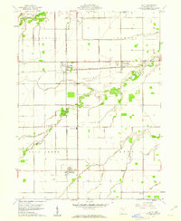 1960 Latty1961 Print · USGSPaulding County is captured here at the start of the 1960s, showing a landscape defined by industrial rail crossings and productive farmland. Genealogists can locate family landmarks like the Blue Creek School, Pleasant View Cemetery, and rural stops in Broughton or Haviland.2 unique versions available
 - 1960 Map of Paulding, 1961 Print
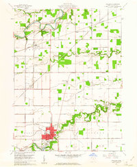 1960 Paulding1961 Print · USGSPaulding County in the early sixties reveals a landscape of industrial kilns and river-bend settlements. Genealogists can trace family names at Upthegrove Cem and Ankney Cem, or locate the historic Eaton Childrens Home and County Home.3 unique versions available
End of results
Showing maps 1-2 of 2
Top cities near Paulding
- Defiance historical maps
- Hicksville historical maps
- Antwerp historical maps
- Payne historical maps
- Convoy historical maps
- Sherwood historical maps
See more
Frequently asked questions
- What are the different types of historical maps available for Paulding?
- What is the oldest map of Paulding?
- Where can I purchase historical maps of Paulding for my home or office?
- Where can I download high-res historical maps of Paulding?
- Are there historical topographic maps available for Paulding?
- Is there historical aerial imagery available for Paulding?
- Where are historical maps of Paulding sourced from?