1960s Maps of Durant, Oklahoma
Explore 3 historic maps of Durant from the 1960s. These maps offer a rare glimpse into what life looked like during the 1960s — showing old roads, neighborhoods, homes, and landmarks that have changed or disappeared over time.
Whether you're researching your family's past, planning a metal detecting trip, or studying how Durant's landscape evolved across the 1960s, these high-resolution maps are a powerful tool for exploring the history of this region.
- Focus on a specific era: All maps on this page are from the 1960s, giving you a focused view of this time period.
- See what’s changed: Compare century-old streets, trails, and buildings to today's modern landscape using overlays and satellite layers.
- Research with precision: Use these maps for genealogy, historical research, land use analysis, or educational projects.
- View, download, or print: Maps are fully viewable online in high resolution, and can be downloaded or printed for your own records.
Start exploring Durant's history through authentic maps from the 1960s. This is your window into the past.
Durant, OK maps
(3)- 1963 Map of Ardmore
 1963 Ardmore1963 Print · USGSSouthern Oklahoma during the early sixties shows a landscape defined by the Arbuckle Mountains and a booming energy economy. Genealogists and historians can trace family-named sites across the Ardmore Oil Field, find old schools like Southeastern State College, or locate historic markers such as Boggy Depot State Park.2 unique versions available
 - 1968 Map of Durant North, 1971 Print
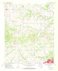 1968 Durant North1971 Print · USGSBryan County in the late sixties shows a landscape shaped by historical lines and collegiate growth north of Durant. Genealogists and historians can trace family locations near Keffer Cem and Brown, or locate the exact course of the Indian Treaty Boundary.
 - 1969 Map of Caddo South, 1971 Print
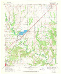 1969 Caddo South1971 Print · USGSBryan County in the late sixties is defined by its transit corridors and the sprawling river valleys of the Blue River. Genealogists and historians can trace the rural infrastructure of Armstrong and Wasseta or locate landmarks like Pleasant Hill Cem and the State Fish Hatchery.
End of results
Showing maps 1-3 of 3
Top cities near Durant
- Denison historical maps
- Calera historical maps
- Colbert historical maps
- Caddo historical maps
- Cartwright historical maps
- Achille historical maps
See more
Top neighborhoods of Durant
- Ury historical maps
- Market Square historical maps
- Glenwood Subdivision historical maps
- Heritage Crossing historical maps
- Oak Hills historical maps
- Prestonwood historical maps
See more
Frequently asked questions
- What are the different types of historical maps available for Durant?
- What is the oldest map of Durant?
- Where can I purchase historical maps of Durant for my home or office?
- Where can I download high-res historical maps of Durant?
- Are there historical topographic maps available for Durant?
- Is there historical aerial imagery available for Durant?
- Where are historical maps of Durant sourced from?