1980s Maps of Durant, Oklahoma
Explore 4 historic maps of Durant from the 1980s. These maps offer a rare glimpse into what life looked like during the 1980s — showing old roads, neighborhoods, homes, and landmarks that have changed or disappeared over time.
Whether you're researching your family's past, planning a metal detecting trip, or studying how Durant's landscape evolved across the 1980s, these high-resolution maps are a powerful tool for exploring the history of this region.
- Focus on a specific era: All maps on this page are from the 1980s, giving you a focused view of this time period.
- See what’s changed: Compare century-old streets, trails, and buildings to today's modern landscape using overlays and satellite layers.
- Research with precision: Use these maps for genealogy, historical research, land use analysis, or educational projects.
- View, download, or print: Maps are fully viewable online in high resolution, and can be downloaded or printed for your own records.
Start exploring Durant's history through authentic maps from the 1980s. This is your window into the past.
Durant, OK maps
(4)- 1980 Map of Durant South, 1981 Print
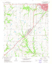 1980 Durant South1981 Print · USGSThe southern outskirts of Durant and the town of Calera are captured here in the early 1980s, showcasing a mix of municipal growth and historical boundary lines. Researchers can trace the Old Indian Treaty Boundary and locate family burial grounds at Highland Cem or Rose Hill Cem.
 - 1980 Map of Roberta, 1981 Print
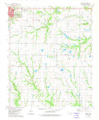 1980 Roberta1981 Print · USGSThe outskirts of Durant and the surrounding rural communities of Bryan County are captured here in the 1980s. Genealogists and local historians can trace legacy sites like Pioneer Cem, George Washington Sch, and the community at Roberta.
 - 1985 Map of Tishomingo, 1986 Print
 1985 Tishomingo1986 Print · USGSSouthern Oklahoma in the mid-eighties reveals a landscape shaped by significant water projects and conservation lands. Genealogists and historians can trace the footprints of communities like Wapanucka and Bromide alongside the Washita River and Lake Texoma.3 unique versions available
 - 1985 Map of Sherman, 1991 Print
 1985 Sherman1991 Print · USGSThe borderlands of North Texas and Southern Oklahoma are captured here in the mid-eighties, centered on the expansive waters of Lake Texoma. Researchers can trace the legacy of the regional rail economy through the Missouri-Kansas-Texas RR or explore the geography of Hagerman National Wildlife Refuge and Carpenters Bluff.
End of results
Showing maps 1-4 of 4
Top cities near Durant
- Denison historical maps
- Calera historical maps
- Colbert historical maps
- Caddo historical maps
- Cartwright historical maps
- Achille historical maps
See more
Top neighborhoods of Durant
- Ury historical maps
- Market Square historical maps
- Glenwood Subdivision historical maps
- Heritage Crossing historical maps
- Oak Hills historical maps
- Prestonwood historical maps
See more
Frequently asked questions
- What are the different types of historical maps available for Durant?
- What is the oldest map of Durant?
- Where can I purchase historical maps of Durant for my home or office?
- Where can I download high-res historical maps of Durant?
- Are there historical topographic maps available for Durant?
- Is there historical aerial imagery available for Durant?
- Where are historical maps of Durant sourced from?