1960s Maps of Healdton, Oklahoma
Explore 3 historic maps of Healdton from the 1960s. These maps offer a rare glimpse into what life looked like during the 1960s — showing old roads, neighborhoods, homes, and landmarks that have changed or disappeared over time.
Whether you're researching your family's past, planning a metal detecting trip, or studying how Healdton's landscape evolved across the 1960s, these high-resolution maps are a powerful tool for exploring the history of this region.
- Focus on a specific era: All maps on this page are from the 1960s, giving you a focused view of this time period.
- See what’s changed: Compare century-old streets, trails, and buildings to today's modern landscape using overlays and satellite layers.
- Research with precision: Use these maps for genealogy, historical research, land use analysis, or educational projects.
- View, download, or print: Maps are fully viewable online in high resolution, and can be downloaded or printed for your own records.
Start exploring Healdton's history through authentic maps from the 1960s. This is your window into the past.
Healdton, OK maps
(3)- 1963 Map of Ardmore
 1963 Ardmore1963 Print · USGSSouthern Oklahoma during the early sixties shows a landscape defined by the Arbuckle Mountains and a booming energy economy. Genealogists and historians can trace family-named sites across the Ardmore Oil Field, find old schools like Southeastern State College, or locate historic markers such as Boggy Depot State Park.2 unique versions available
 - 1969 Map of Healdton, 1971 Print
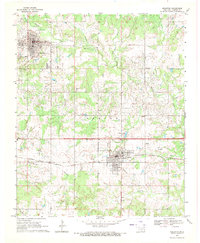 1969 Healdton1971 Print · USGSOil extraction and rail commerce define this Oklahoma landscape during the late sixties. Researchers can trace family history at Mt Olive Cemetery and explore the industrial layout of Hewitt Field between the towns of Healdton and Wilson.
 - 1969 Map of Fox, 1971 Print
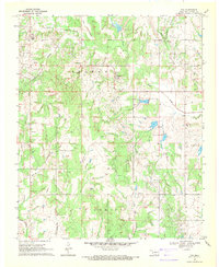 1969 Fox1971 Print · USGSOil extraction and rural life converge in Carter County during the late 1960s, showing the extensive infrastructure of the local petroleum industry. Researchers can pinpoint early oil well locations, follow the path of Hug-me-tight Branch, and locate landmarks like Midway Ch and Oil Springs Cem.
End of results
Showing maps 1-3 of 3
Top cities near Healdton
- Duncan historical maps
- Lone Grove historical maps
- Wilson historical maps
- Ringling historical maps
- Velma historical maps
- Cornish historical maps
See more
Top neighborhoods of Healdton
Frequently asked questions
- What are the different types of historical maps available for Healdton?
- What is the oldest map of Healdton?
- Where can I purchase historical maps of Healdton for my home or office?
- Where can I download high-res historical maps of Healdton?
- Are there historical topographic maps available for Healdton?
- Is there historical aerial imagery available for Healdton?
- Where are historical maps of Healdton sourced from?