1900s (20th Century) Maps of Geary, Oklahoma
Explore 10 historic maps of Geary from the 1900s (20th Century). These maps offer a rare glimpse into what life looked like during the 1900s — showing old roads, neighborhoods, homes, and landmarks that have changed or disappeared over time.
Whether you're researching your family's past, planning a metal detecting trip, or studying how Geary's landscape evolved across the 1900s, these high-resolution maps are a powerful tool for exploring the history of this region.
- Focus on a specific era: All maps on this page are from the 1900s, giving you a focused view of this time period.
- See what’s changed: Compare century-old streets, trails, and buildings to today's modern landscape using overlays and satellite layers.
- Research with precision: Use these maps for genealogy, historical research, land use analysis, or educational projects.
- View, download, or print: Maps are fully viewable online in high resolution, and can be downloaded or printed for your own records.
Start exploring Geary's history through authentic maps from the 1900s. This is your window into the past.
Geary, OK maps
(10)- 1941 Map of Fort Reno
 1941 Fort Reno1941 Print · USGSThe North Canadian River valley was a center of agricultural and military life in the late thirties. Genealogists can trace family footprints across dozens of country schools and churches like Sunny Hill Sch, Swappingback Indian Chapel, and the historic Fort Reno grounds.3 unique versions available
 - 1942 Map of Fort Reno
 1942 Fort Reno1942 Print · USGSOklahoma's Canadian County plains come alive in this early-forties survey, showcasing a landscape defined by military depots and tribal schools. Researchers can trace rural lineages through dozens of local sites like Banner Sch, Canadian Valley Cem, and the Fort Reno garrison.
 - 1942 Map of Geary
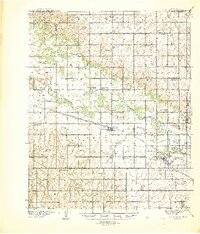
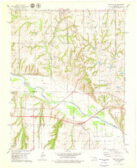
 1942 Geary1942 Print · USGSCentral Oklahoma's agrarian heartland comes alive in this pre-war survey of the winding Canadian River valley. Genealogists and local historians can map out dozens of rural school sites like Victor Sch and Richland Sch alongside the busy Chicago Rock Island and Pacific rail line.3 unique versions available
 - 1949 Map of Fort Reno
 1949 Fort Reno1949 Print · USGSOklahoma's Canadian County comes to life in this mid-century survey, capturing the unique intersection of military history, tribal education, and Route 66 commerce. Genealogists can locate family landmarks like Swappingback Indian Chapel, Calumet, and the expansive Fort Reno Military Reservation.
 - 1955 Map of Clinton, 1964 Print
 1955 Clinton1964 Print · USGSWestern Oklahoma during the mid-century transition shows a landscape of growing reservoirs and active military flight lines. Genealogists and historians can locate rural landmarks such as Mountain View Church, Berlin School, and the Riverside Indian School Reserve.3 unique versions available
 - 1957 Map of Clinton
 1957 Clinton1957 Print · USGSWestern Oklahoma in the mid-fifties is captured here as a landscape of river-valley settlements and emerging energy fields. Genealogists can trace family roots through numerous rural landmarks like the Swapping Back Indian School, Hebron Church, and the Riverside Indian School Reserve.
 - 1967 Map of Fort Reno SW, 1969 Print
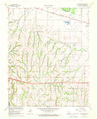 1967 Fort Reno SW1969 Print · USGSCanadian County, Oklahoma, in the late sixties shows a transition from river valley farming to a landscape dotted with the energy industry. Researchers can trace rural school locations like Maple Sch, the Rock Island rail corridor, and local burial sites at Sunny Hill Cem.
 - 1979 Map of Geary North
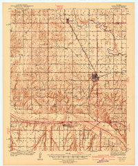
 1979 Geary North1979 Print · USGSSettlement in Blaine County and Canadian County during the late 1970s is centered around the rail hub of Geary. Trace the diagonal route of the Chicago Rock Island and Pacific or locate rural landmarks like Grandview Ch and Left Hand Spring.
 - 1979 Map of Geary South
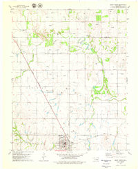
 1979 Geary South1979 Print · USGSThe Canadian River valley in the late seventies reveals a landscape shaped by rail, river, and rural industry. Researchers can trace the Chicago Rock Island and Pacific rail lines, the Old Railroad Grade, and local sites like Graceland Cem and Hinton Junction.2 unique versions available
 - 1985 Map of Watonga
 1985 Watonga1985 Print · USGSCentral Oklahoma in the mid-eighties shows a robust network of river-valley settlements and rural rail lines. Genealogists and historians can trace the footprint of Southwestern State College, the historic Fort Reno, and family-named landmarks like Dead Women Crossing.2 unique versions available
End of results
Showing maps 1-10 of 10
Top cities near Geary
- El Reno historical maps
- Hinton historical maps
- Calumet historical maps
- Greenfield historical maps
- Bridgeport historical maps
- Lookeba historical maps
Frequently asked questions
- What are the different types of historical maps available for Geary?
- What is the oldest map of Geary?
- Where can I purchase historical maps of Geary for my home or office?
- Where can I download high-res historical maps of Geary?
- Are there historical topographic maps available for Geary?
- Is there historical aerial imagery available for Geary?
- Where are historical maps of Geary sourced from?