1960s Maps of Chickasha, Oklahoma
Explore 5 historic maps of Chickasha from the 1960s. These maps offer a rare glimpse into what life looked like during the 1960s — showing old roads, neighborhoods, homes, and landmarks that have changed or disappeared over time.
Whether you're researching your family's past, planning a metal detecting trip, or studying how Chickasha's landscape evolved across the 1960s, these high-resolution maps are a powerful tool for exploring the history of this region.
- Focus on a specific era: All maps on this page are from the 1960s, giving you a focused view of this time period.
- See what’s changed: Compare century-old streets, trails, and buildings to today's modern landscape using overlays and satellite layers.
- Research with precision: Use these maps for genealogy, historical research, land use analysis, or educational projects.
- View, download, or print: Maps are fully viewable online in high resolution, and can be downloaded or printed for your own records.
Start exploring Chickasha's history through authentic maps from the 1960s. This is your window into the past.
Chickasha, OK maps
(5)- 1963 Map of Ardmore
 1963 Ardmore1963 Print · USGSSouthern Oklahoma during the early sixties shows a landscape defined by the Arbuckle Mountains and a booming energy economy. Genealogists and historians can trace family-named sites across the Ardmore Oil Field, find old schools like Southeastern State College, or locate historic markers such as Boggy Depot State Park.2 unique versions available
 - 1963 Map of Oklahoma City
 1963 Oklahoma City1963 Print · USGSCentral Oklahoma in the early sixties showcases a landscape of rapid suburban growth and established oil production. Researchers can trace historic rail lines like the Chicago Rock Island and Pacific RR or locate rural landmarks such as Mayflower School and Bethel Church.
 - 1966 Map of Chickasha, 1967 Print
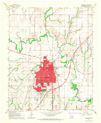 1966 Chickasha1967 Print · USGSChickasha flourished as a vital rail and educational center in central Oklahoma during the mid-sixties. Local researchers can trace the Indian Territory Boundary Line and locate historic sites like the Oklahoma College for Women and Rose Hill Cemetery.2 unique versions available
 - 1966 Map of Tabler, 1967 Print
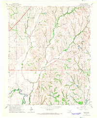 1966 Tabler1967 Print · USGSGrady County rural life in the mid-1960s is centered around the Washita River and the crossroads at Tabler. Researchers can trace the path of an Old Railroad Grade or locate historic settlement sites like Lucille, Naples, and Middleberg.2 unique versions available
 - 1968 Map of Verden, 1969 Print
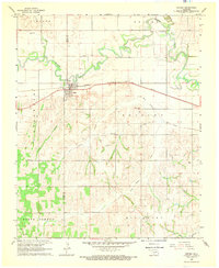 1968 Verden1969 Print · USGSThe town of Verden and the winding Washita River define this Oklahoma landscape in the late sixties. Researchers can trace the path of the Chicago Rock Island and Pacific railroad or locate local landmarks like the Mennonite Ch and Elderberry Ch.
End of results
Showing maps 1-5 of 5
Top cities near Chickasha
- Blanchard historical maps
- Ninnekah historical maps
- Verden historical maps
- Alex historical maps
- Amber historical maps
- Cement historical maps
See more
Frequently asked questions
- What are the different types of historical maps available for Chickasha?
- What is the oldest map of Chickasha?
- Where can I purchase historical maps of Chickasha for my home or office?
- Where can I download high-res historical maps of Chickasha?
- Are there historical topographic maps available for Chickasha?
- Is there historical aerial imagery available for Chickasha?
- Where are historical maps of Chickasha sourced from?