1970s Maps of Kiowa County, Oklahoma
Explore 2 historic maps of Kiowa County from the 1970s. These maps offer a rare glimpse into what life looked like during the 1970s — showing old roads, neighborhoods, homes, and landmarks that have changed or disappeared over time.
Whether you're researching your family's past, planning a metal detecting trip, or studying how Kiowa County's landscape evolved across the 1970s, these high-resolution maps are a powerful tool for exploring the history of this region.
- Focus on a specific era: All maps on this page are from the 1970s, giving you a focused view of this time period.
- See what’s changed: Compare century-old streets, trails, and buildings to today's modern landscape using overlays and satellite layers.
- Research with precision: Use these maps for genealogy, historical research, land use analysis, or educational projects.
- View, download, or print: Maps are fully viewable online in high resolution, and can be downloaded or printed for your own records.
Start exploring Kiowa County's history through authentic maps from the 1970s. This is your window into the past.
Kiowa County, OK maps
(2)- 1971 Map of Blair, 1973 Print
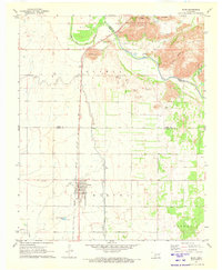 1971 Blair1973 Print · USGSThe agricultural plains of Southwest Oklahoma meet the granite peaks of the Wichita Mountains in the early seventies. Genealogists and historians can trace the irrigation networks of the West Canal and locate landmarks like Blair Cem and City View.2 unique versions available
 - 1971 Map of Lake Altus, 1973 Print
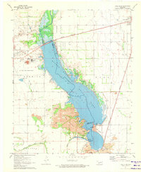 1971 Lake Altus1973 Print · USGSSouthwestern Oklahoma's landscape was defined by massive water projects and rugged granite peaks in the early 1970s. Trace the lakefront of Quartz Mountain Lake, the rails of the Atchison Topeka and Santa Fe, and the townsite of Lugert.
End of results
Showing maps 1-2 of 2
Top cities of Kiowa County
- Hobart historical maps
- Snyder historical maps
- Mountain View historical maps
- Lone Wolf historical maps
- Mountain Park historical maps
- Roosevelt historical maps
See more
Frequently asked questions
- What are the different types of historical maps available for Kiowa County?
- What is the oldest map of Kiowa County?
- Where can I purchase historical maps of Kiowa County for my home or office?
- Where can I download high-res historical maps of Kiowa County?
- Are there historical topographic maps available for Kiowa County?
- Is there historical aerial imagery available for Kiowa County?
- Where are historical maps of Kiowa County sourced from?