1980s Maps of Kiowa County, Oklahoma
Explore 12 historic maps of Kiowa County from the 1980s. These maps offer a rare glimpse into what life looked like during the 1980s — showing old roads, neighborhoods, homes, and landmarks that have changed or disappeared over time.
Whether you're researching your family's past, planning a metal detecting trip, or studying how Kiowa County's landscape evolved across the 1980s, these high-resolution maps are a powerful tool for exploring the history of this region.
- Focus on a specific era: All maps on this page are from the 1980s, giving you a focused view of this time period.
- See what’s changed: Compare century-old streets, trails, and buildings to today's modern landscape using overlays and satellite layers.
- Research with precision: Use these maps for genealogy, historical research, land use analysis, or educational projects.
- View, download, or print: Maps are fully viewable online in high resolution, and can be downloaded or printed for your own records.
Start exploring Kiowa County's history through authentic maps from the 1980s. This is your window into the past.
Kiowa County, OK maps
(12)- 1981 Map of Lawton
 1981 Lawton1981 Print · USGSSouthwestern Oklahoma in the early eighties shows a landscape shaped by military history and the rising peaks of the Wichitas. Researchers can trace the boundaries of the Fort Sill Military Reservation and locate early settlements like Meers, Chattanooga, and Richards Spur.
 - 1984 Map of Gotebo East, 1985 Print
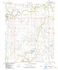
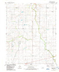
 1984 Gotebo East1985 Print · USGSKiowa and Washita counties are shown here in the mid-1980s, where the landscape is still defined by early territorial markers. Researchers can trace the Old Indian Treaty Boundary and locate historic sites like the Rainy Mountain Indian Mission and Mountain View Cem.
 - 1984 Map of Carnegie, 1985 Print
 1984 Carnegie1985 Print · USGSCaddo County's agricultural and energy landscape comes alive in this mid-1980s survey of the Carnegie area. Researchers can trace the C R I & P railroad line and locate local landmarks such as Botone Memorial Ch and Carnegie Cem.
 - 1984 Map of Stinking Creek, 1985 Print
 1984 Stinking Creek1985 Print · USGSOklahoma's Washita River valley comes into focus during the 1980s, revealing a landscape defined by treaty lines and river bends. Genealogists and historians can trace the Old Indian Treaty Boundary and locate local landmarks like Antique Mem Cem and Little Red Ch.
 - 1984 Map of Hobart, 1985 Print
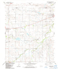
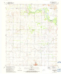
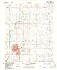 1984 Hobart1985 Print · USGSOklahoma's Kiowa County plains come alive in the mid-eighties as a hub of ranching, oil, and education. Researchers can trace local heritage through Rose Cem, the Rainey Mountain Indian Treaty Boundary, and the site of the Willard Sch.
 - 1984 Map of Cambridge, 1985 Print
 1984 Cambridge1985 Print · USGSWestern Oklahoma’s prairie landscape is captured in the mid-1980s, centered on the rural intersection of Cambridge. You can trace the path of the Atchison Topeka and Santa Fe railroad or locate local landmarks like Pleasant Ridge Cem.
 - 1984 Map of Gotebo West, 1985 Print
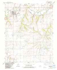
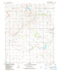 1984 Gotebo West1985 Print · USGSIn the mid-1980s, this area of Kiowa County was a bustling hub of energy production and agricultural commerce. Researchers can trace the Rainy Mountain Indian Treaty Boundary, find the Wyatt Cem, and locate the Old Railroad Grade passing through Gotebo.
 - 1985 Map of Elk City
 1985 Elk City1985 Print · USGSWestern Oklahoma in the 1980s is defined by its railroad junctions, emerging aviation hubs, and the winding North Fork Red River. Genealogists and local historians can trace the foundations of Sayre and Elk City, alongside landmarks like Clinton-Sherman Airport and Quartz Mountain State Park.2 unique versions available
 - 1985 Map of Altus
 1985 Altus1985 Print · USGSSouthwestern Oklahoma in the mid-eighties shows a vast agricultural and military landscape shaped by the Red River forks. Trace the intersections of the Atchison Topeka and Santa Fe railroad with rural points like Fairmount Cem and Duke.2 unique versions available
 - 1986 Map of Anadarko
 1986 Anadarko1986 Print · USGSThe Oklahoma plains around Anadarko are captured in the mid-1980s, showing the intersection of rail history and tribal heritage. Genealogists and historians can trace the Indian Treaty Boundary or locate old rail stops along the Burlington Northern Railroad and Atchison, Topeka and Santa Fe Railway.2 unique versions available
 - 1989 Map of Lake Creek
 1989 Lake Creek1989 Print · USGSSouthwestern Oklahoma in the late eighties shows a landscape of ranching and energy production at the meeting of three counties. Trace family history at Pleasant Valley Cem and explore the winding North Fork Red River near Lake Creek.
 - 1989 Map of Retrop SE
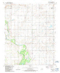 1989 Retrop SE1989 Print · USGSThe river bottomlands of Kiowa County meet the open plains of Greer and Washita counties during the late twentieth century. Genealogists and historians can trace local land use through features like the Altus-Lugert State Wildlife Management Area and scattered energy sites like the Oil Well near the North Fork Red River.
End of results
Showing maps 1-12 of 12
Top cities of Kiowa County
- Hobart historical maps
- Snyder historical maps
- Mountain View historical maps
- Lone Wolf historical maps
- Mountain Park historical maps
- Roosevelt historical maps
See more
Frequently asked questions
- What are the different types of historical maps available for Kiowa County?
- What is the oldest map of Kiowa County?
- Where can I purchase historical maps of Kiowa County for my home or office?
- Where can I download high-res historical maps of Kiowa County?
- Are there historical topographic maps available for Kiowa County?
- Is there historical aerial imagery available for Kiowa County?
- Where are historical maps of Kiowa County sourced from?