1950s Maps of LeFlore County, Oklahoma
Explore 13 historic maps of LeFlore County from the 1950s. These maps offer a rare glimpse into what life looked like during the 1950s — showing old roads, neighborhoods, homes, and landmarks that have changed or disappeared over time.
Whether you're researching your family's past, planning a metal detecting trip, or studying how LeFlore County's landscape evolved across the 1950s, these high-resolution maps are a powerful tool for exploring the history of this region.
- Focus on a specific era: All maps on this page are from the 1950s, giving you a focused view of this time period.
- See what’s changed: Compare century-old streets, trails, and buildings to today's modern landscape using overlays and satellite layers.
- Research with precision: Use these maps for genealogy, historical research, land use analysis, or educational projects.
- View, download, or print: Maps are fully viewable online in high resolution, and can be downloaded or printed for your own records.
Start exploring LeFlore County's history through authentic maps from the 1950s. This is your window into the past.
LeFlore County, OK maps
(13)- 1950 Map of Mcalester
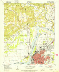
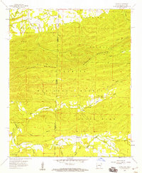
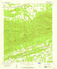
 1950 Mcalester1950 Print · USGSThe Ouachita Mountains and the coal country of Southeast Oklahoma are shown here in the late 1940s. Genealogists and historians can trace the rail-driven growth of McAlester, Wilburton, and Antlers alongside the rugged terrain of Kiamichi Mountain.2 unique versions available
 - 1951 Map of Fort Smith
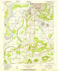
 1951 Fort Smith1951 Print · USGSFort Smith and its neighboring Oklahoma borderlands are captured here during a period of significant mid-century growth and industrial connectivity. Researchers can trace the development of urban neighborhoods and rural outposts like Moffett, Dora, and Bluemouse School.2 unique versions available
 - 1951 Map of South Fort Smith
 1951 South Fort Smith1951 Print · USGSThe Arkansas-Oklahoma borderlands in the early fifties show a landscape of river-bend farming and industrial growth. Genealogists can trace family roots through several rural schools like Pocola School, old burial grounds at Oak Cemetery, and community landmarks like the White Bluff Church.2 unique versions available
 - 1951 Map of Hartford
 1951 Hartford1951 Print · USGSThe borderlands of Arkansas and Oklahoma come alive in this mid-century survey of the coal-mining and ridge-country landscape. Genealogists and researchers can trace local landmarks like Slaytonville, Hartford, and the industrial Coal sites near the foot of Midland Peak.2 unique versions available
 - 1951 Map of Hackett
 1951 Hackett1951 Print · USGSThe Arkansas-Oklahoma borderlands come alive in the early fifties, showing the peak of the region's coal and rail era. Researchers can trace the industrial footprint of Strip mines near Bonanza or locate family sites like Old Union Church and Mt View Cemetery.2 unique versions available
 - 1958 Map of Loving, 1959 Print
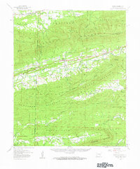
 1958 Loving1959 Print · USGSThe Arkansas-Oklahoma borderlands come into focus in the late 1950s as the Ouachita National Forest meets the winding Poteau River. Researchers can trace old family sites and rural landmarks like the Loving Cem, Black Fork Cem, and the Haws Creek Ch.3 unique versions available
 - 1958 Map of Bates, 1959 Print
 1958 Bates1959 Print · USGSThe Arkansas-Oklahoma borderlands in the late fifties reveal a landscape of ridge-top forests and valley industry. Researchers can trace rural lineages through local landmarks like Hiawatha School, Cauthron, and several family burial grounds including Sligar Cem and Loving Cem.
 - 1958 Map of Potter, 1959 Print
 1958 Potter1959 Print · USGSThe Arkansas-Oklahoma borderlands are shown here in the late fifties, dominated by the ridges of the Ouachita National Forest. Researchers can locate old settlements like Zafra and Potter, family cemeteries such as Sexton Cem, and the path of the Kansas City Southern RR.3 unique versions available
 - 1958 Map of Zafra, 1959 Print
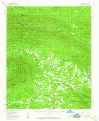
 1958 Zafra1959 Print · USGSThe Arkansas-Oklahoma state line in the late fifties was a land of high peaks and isolated community life. Genealogists and historians can trace family locations through Zafra Sch, Stinett Cem, and the rural Alder Springs Ch along the Little River.4 unique versions available
 - 1958 Map of Bates, 1959 Print
 1958 Bates1959 Print · USGSThe Arkansas-Oklahoma borderlands in the late fifties are defined by the timbered slopes of the Ouachita National Forest. Researchers can trace the industrial corridor of the Kansas City Southern railroad through Coaldale and Bates to find family sites like Sliger Cem.3 unique versions available
 - 1958 Map of Mountain Fork, 1959 Print
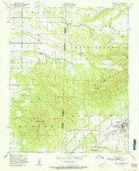
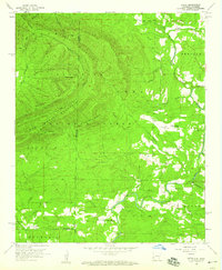
 1958 Mountain Fork1959 Print · USGSThe Arkansas-Oklahoma state line runs through these high ridges in the late fifties, where the Kansas City Southern railroad winds through the mountains. Researchers can trace the development of Wilhelmina State Park and locate historic sites like Healy Cem and the settlement at Mountain Fork.3 unique versions available
 - 1959 Map of Page, 1960 Print
 1959 Page1960 Print · USGSSoutheast Oklahoma in the late fifties was a region of high ridges and narrow river valleys. Genealogists and historians can trace the rural communities of Octavia and Big Cedar, the path of the Kansas City Southern railroad, and landmarks like New Home Ch.3 unique versions available
 - 1959 Map of Heavener, 1960 Print
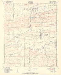
 1959 Heavener1960 Print · USGSEastern Oklahoma's Poteau River valley appears here during a period of transition, where established rail hubs meet the newly formed waters of Lake Wister. You can trace early township life through sites like Hodgens, the Springhill Cem, and the tracks of the Chicago Rock Island and Pacific RR.2 unique versions available
End of results
Showing maps 1-13 of 13
Top cities of LeFlore County
- Poteau historical maps
- Pocola historical maps
- Heavener historical maps
- Spiro historical maps
- Arkoma historical maps
- Panama historical maps
See more
Frequently asked questions
- What are the different types of historical maps available for LeFlore County?
- What is the oldest map of LeFlore County?
- Where can I purchase historical maps of LeFlore County for my home or office?
- Where can I download high-res historical maps of LeFlore County?
- Are there historical topographic maps available for LeFlore County?
- Is there historical aerial imagery available for LeFlore County?
- Where are historical maps of LeFlore County sourced from?