1970s Maps of LeFlore County, Oklahoma
Explore 16 historic maps of LeFlore County from the 1970s. These maps offer a rare glimpse into what life looked like during the 1970s — showing old roads, neighborhoods, homes, and landmarks that have changed or disappeared over time.
Whether you're researching your family's past, planning a metal detecting trip, or studying how LeFlore County's landscape evolved across the 1970s, these high-resolution maps are a powerful tool for exploring the history of this region.
- Focus on a specific era: All maps on this page are from the 1970s, giving you a focused view of this time period.
- See what’s changed: Compare century-old streets, trails, and buildings to today's modern landscape using overlays and satellite layers.
- Research with precision: Use these maps for genealogy, historical research, land use analysis, or educational projects.
- View, download, or print: Maps are fully viewable online in high resolution, and can be downloaded or printed for your own records.
Start exploring LeFlore County's history through authentic maps from the 1970s. This is your window into the past.
LeFlore County, OK maps
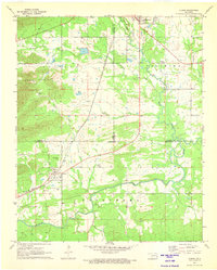
(16)- 1970 Map of Muldrow SW
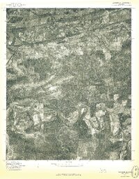
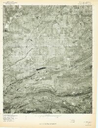
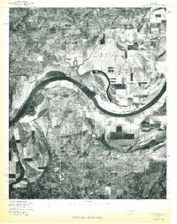
 1970 Muldrow SW1970 Print · USGSLe Flore County in the late seventies is captured in this orthophoto survey, showcasing the winding Arkansas River and its rural borderlands. Researchers can trace land divisions near Tucker or follow the paths of Onion Creek and Cache Creek as they weave through the valley.
 - 1971 Map of Albion, 1973 Print
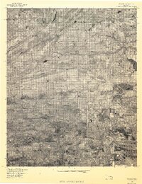
 1971 Albion1973 Print · USGSSoutheast Oklahoma in the early 1970s reveals a landscape of deep valleys and winding waterways where the railroad still shaped local life. Genealogists can trace family names through rural landmarks like Armstrong Cem, Myers Cem, and the Evangelistic Tabernacle.2 unique versions available
 - 1976 Map of Heavener SE
 1976 Heavener SE1976 Print · USGSLe Flore County’s wooded foothills and river valleys are captured in this mid-seventies aerial survey. Genealogists and local historians can trace the rural layout of communities like Hontubby, Stapp, and Haw Creek along the Poteau River.
 - 1976 Map of Fort Smith, 1978 Print
 1976 Fort Smith1978 Print · USGSFort Smith and the Oklahoma borderlands are captured in high-contrast detail in the mid-seventies, showing the region's transition from urban center to rural floodplain. Researchers can trace the layout of the city near Moffett or study the agricultural plots and timberlines surrounding Roland and Dora.
 - 1977 Map of Mc Curtain SW
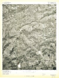
 1977 Mc Curtain SW1977 Print · USGSLe Flore County land use and mountain terrain are captured in this 1970s aerial survey. Local researchers can trace old homesteads and timberlines near small communities like Brazil, Walls, and Cedar along the slopes of the Sans Bois Mountains.
 - 1977 Map of Poteau East
 1977 Poteau East1977 Print · USGSEastern Oklahoma in the late seventies is captured in this detailed aerial perspective, showing the valley where the river meets the plains. Local historians can trace the winding Poteau River and the rural layout of Gilmore and Poteau.
 - 1977 Map of Mc Curtain
 1977 Mc Curtain1977 Print · USGSHaskell County's ridged terrain and late-seventies settlement patterns are documented in this orthophotoquad. Researchers can trace the literal footprint of Mc Curtain or locate the shoreline where the Robert S. Kerr Reservoir meets Ironbridge.
 - 1977 Map of Panama
 1977 Panama1977 Print · USGSEastern Oklahoma in the late 1970s reveals a landscape defined by the winding Poteau River and established rural townships. Genealogists and local historians can trace property and settlement patterns in Panama, Shady Point, and along the slopes of Nubbin Ridge.
 - 1977 Map of Loving
 1977 Loving1977 Print · USGSThe Oklahoma-Arkansas borderlands are captured in this late-seventies aerial survey, showing the rural community of Loving. Researchers can trace the wooded ridges of Walker Mountain and the winding paths of the Poteau River and Black Fork.
 - 1977 Map of Poteau West
 1977 Poteau West1977 Print · USGSEastern Oklahoma's landscape is captured during the late seventies, centered on the prominent heights west of the county seat. Genealogists and local historians can trace the rural layouts of Calhoun, Witteville, and Smacker near the Poteau River.
 - 1977 Map of Fort Coffee
 1977 Fort Coffee1977 Print · USGSEastern Oklahoma's riverine landscape is captured in the late seventies, showing the sweeping bends of the Arkansas River. Genealogists and local historians can pinpoint the exact layouts of Fort Coffee, Murry Spur, and the fields of Paw Paw Bottom.
 - 1977 Map of Potato Peaks
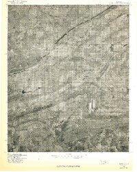
 1977 Potato Peaks1977 Print · USGSLe Flore County in the late seventies is captured in this aerial survey, showing the rural communities and high ridges of the Ouachita foothills. Researchers can trace the clearings around Latham and Kennady or locate the wooded heights of Potato Peaks.
 - 1977 Map of Bokoshe
 1977 Bokoshe1977 Print · USGSBokoshe and the industrial landscapes of Le Flore County are seen here in the late seventies through detailed aerial photography. Researchers can trace the exact layout of settlements like Cartersville and Milton or locate Campground Spring Mountain.
 - 1978 Map of Fort Smith, 1979 Print
 1978 Fort Smith1979 Print · USGSThe Arkansas-Oklahoma borderlands in the late seventies show a landscape shaped by massive river reservoirs and sprawling military reservations. Trace the historic rail lines of the Missouri Pacific RR and locate regional landmarks like Fort Gibson, Tenkiller Ferry Lake, and Barling.2 unique versions available
 - 1978 Map of Fort Smith, 1979 Print
 1978 Fort Smith1979 Print · USGSThe Arkansas-Oklahoma borderlands in the late seventies show a region defined by river navigation, coal mining, and military expansion. You can trace industrial footprints like the Strip Mines and the vast Fort Chaffee Military Reservation.2 unique versions available
 - 1979 Map of Talihina, 1980 Print
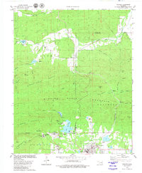 1979 Talihina1980 Print · USGSThe Ouachita foothills near the end of the seventies show a landscape of mountain ridges and medical institutions. Genealogists and local historians can trace family roots at the Peachland Cem or locate the US Government Hospital and Kiamichi Camp.
End of results
Showing maps 1-16 of 16
Top cities of LeFlore County
- Poteau historical maps
- Pocola historical maps
- Heavener historical maps
- Spiro historical maps
- Arkoma historical maps
- Panama historical maps
See more
Frequently asked questions
- What are the different types of historical maps available for LeFlore County?
- What is the oldest map of LeFlore County?
- Where can I purchase historical maps of LeFlore County for my home or office?
- Where can I download high-res historical maps of LeFlore County?
- Are there historical topographic maps available for LeFlore County?
- Is there historical aerial imagery available for LeFlore County?
- Where are historical maps of LeFlore County sourced from?