1970s Maps of Major County, Oklahoma
Explore 6 historic maps of Major County from the 1970s. These maps offer a rare glimpse into what life looked like during the 1970s — showing old roads, neighborhoods, homes, and landmarks that have changed or disappeared over time.
Whether you're researching your family's past, planning a metal detecting trip, or studying how Major County's landscape evolved across the 1970s, these high-resolution maps are a powerful tool for exploring the history of this region.
- Focus on a specific era: All maps on this page are from the 1970s, giving you a focused view of this time period.
- See what’s changed: Compare century-old streets, trails, and buildings to today's modern landscape using overlays and satellite layers.
- Research with precision: Use these maps for genealogy, historical research, land use analysis, or educational projects.
- View, download, or print: Maps are fully viewable online in high resolution, and can be downloaded or printed for your own records.
Start exploring Major County's history through authentic maps from the 1970s. This is your window into the past.
Major County, OK maps
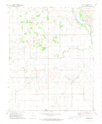
(6)- 1972 Map of Longdale, 1974 Print
 1972 Longdale1974 Print · USGSBlaine County's rural landscape is captured here in the early seventies as the region balanced its agricultural roots with a growing energy sector. Researchers can trace the Atchison Topeka and Santa Fe rail line past Longdale or locate family sites at Bethel Cem and Cedar Springs.
 - 1972 Map of Canton NW, 1974 Print
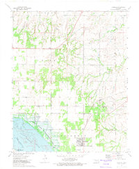
 1972 Canton NW1974 Print · USGSThe rural landscapes of Major and Dewey Counties are captured here in the early 1970s, centered on the waters of Canton Lake. Genealogists and local historians can trace family locations near the Fern Cliff Cem, the settlement of Bado, and Midway Ch.
 - 1972 Map of Seiling, 1974 Print
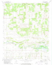
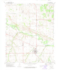 1972 Seiling1974 Print · USGSNorthwest Oklahoma's river valley comes alive in this early 1970s survey centered on the junction of Dewey, Major, and Woodward counties. Genealogists and local historians can locate Elm Grove Ch, Brumfield Cem, and the civic layout of Seiling and Chester.
 - 1972 Map of Homestead, 1974 Print
 1972 Homestead1974 Print · USGSNorthwestern Oklahoma’s rural landscape is captured here in the early seventies, showing a region where rail transit and the gas industry shaped local life. Genealogists and historians can trace local families through Cedar Cemetery, Mennonite Cemetery, and the Homestead settlement.
 - 1972 Map of Isabella, 1974 Print
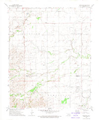
 1972 Isabella1974 Print · USGSNorthwest Oklahoma prairie life is captured here in the early 1970s as energy production and railroads defined the landscape. Genealogists can trace family footprints at Isabella Cem or Bierig Cem and follow the path of the St Louis San Francisco railroad.
 - 1972 Map of Orion, 1974 Print
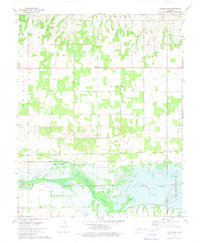
 1972 Orion1974 Print · USGSMajor and Dewey Counties are captured in the early 1970s, showcasing the winding North Canadian River valley and its surrounding farmland. Researchers can locate family landmarks like Orion Cem and Hope Cem, or trace the settlement at Orion.
End of results
Showing maps 1-6 of 6
Top cities of Major County
- Fairview historical maps
- Ringwood historical maps
- Cleo Springs historical maps
- Ames historical maps
- Meno historical maps
Frequently asked questions
- What are the different types of historical maps available for Major County?
- What is the oldest map of Major County?
- Where can I purchase historical maps of Major County for my home or office?
- Where can I download high-res historical maps of Major County?
- Are there historical topographic maps available for Major County?
- Is there historical aerial imagery available for Major County?
- Where are historical maps of Major County sourced from?