1970s Maps of McCurtain County, Oklahoma
Explore 4 historic maps of McCurtain County from the 1970s. These maps offer a rare glimpse into what life looked like during the 1970s — showing old roads, neighborhoods, homes, and landmarks that have changed or disappeared over time.
Whether you're researching your family's past, planning a metal detecting trip, or studying how McCurtain County's landscape evolved across the 1970s, these high-resolution maps are a powerful tool for exploring the history of this region.
- Focus on a specific era: All maps on this page are from the 1970s, giving you a focused view of this time period.
- See what’s changed: Compare century-old streets, trails, and buildings to today's modern landscape using overlays and satellite layers.
- Research with precision: Use these maps for genealogy, historical research, land use analysis, or educational projects.
- View, download, or print: Maps are fully viewable online in high resolution, and can be downloaded or printed for your own records.
Start exploring McCurtain County's history through authentic maps from the 1970s. This is your window into the past.
McCurtain County, OK maps
(4)- 1971 Map of Albion SE, 1973 Print
 1971 Albion SE1973 Print · USGSPushmataha County was a landscape of remote mountain trails and river bottomlands in the early 1970s. Researchers can trace family sites near Fewell, locate the Fewell Cem, and follow the old Wildhorse Trail through the Kiamichi Mountains.
 - 1972 Map of Clebit, 1973 Print
 1972 Clebit1973 Print · USGSIn the Ouachita foothills during the early 1970s, this area shows the intersection of timber-country trails and industrial expansion. Genealogists and researchers can locate the Countyline Cem, trace the Industrial Railroad, and follow the Nolia Trail.
 - 1976 Map of Broken bow NE
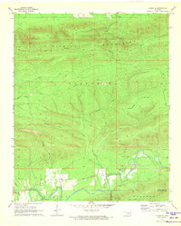
 1976 Broken bow NE1976 Print · USGSMcCurtain County’s timberlands are captured in detail during the mid-seventies, showing the high-country forest before decades of further growth. Researchers can trace the logging roads and clearings surrounding Welch Mountain and West Fork Mountain.
 - 1976 Map of Broken Bow SW
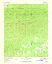
 1976 Broken Bow SW1976 Print · USGSBroken Bow and the surrounding McCurtain County timberlands are captured in high-detail aerial imagery during the mid-seventies. Researchers can trace the development of Broken Bow and the natural path of the Mountain Fork river.
End of results
Showing maps 1-4 of 4
Top cities of McCurtain County
- Idabel historical maps
- Broken Bow historical maps
- Wright City historical maps
- Valliant historical maps
- Millerton historical maps
- Haworth historical maps
See more
Frequently asked questions
- What are the different types of historical maps available for McCurtain County?
- What is the oldest map of McCurtain County?
- Where can I purchase historical maps of McCurtain County for my home or office?
- Where can I download high-res historical maps of McCurtain County?
- Are there historical topographic maps available for McCurtain County?
- Is there historical aerial imagery available for McCurtain County?
- Where are historical maps of McCurtain County sourced from?