1990s Maps of Oklahoma City, Oklahoma
Explore 7 historic maps of Oklahoma City from the 1990s. These maps offer a rare glimpse into what life looked like during the 1990s — showing old roads, neighborhoods, homes, and landmarks that have changed or disappeared over time.
Whether you're researching your family's past, planning a metal detecting trip, or studying how Oklahoma City's landscape evolved across the 1990s, these high-resolution maps are a powerful tool for exploring the history of this region.
- Focus on a specific era: All maps on this page are from the 1990s, giving you a focused view of this time period.
- See what’s changed: Compare century-old streets, trails, and buildings to today's modern landscape using overlays and satellite layers.
- Research with precision: Use these maps for genealogy, historical research, land use analysis, or educational projects.
- View, download, or print: Maps are fully viewable online in high resolution, and can be downloaded or printed for your own records.
Start exploring Oklahoma City's history through authentic maps from the 1990s. This is your window into the past.
Oklahoma City, OK maps
(7)- 1990 Map of Oklahoma City North
 1990 Oklahoma City North1990 Print · USGSOklahoma City and its northern reaches are captured in the 1990s as suburban growth stretched toward the Cimarron River. Genealogists and historians can trace rail-town legacies along the Atchison Topeka and Santa Fe Railroad and find landmarks like the El Reno Federal Reformatory.
 - 1995 Map of Bethany, 1999 Print
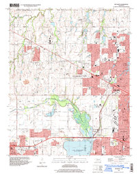 1995 Bethany1999 Print · USGSOklahoma City and its neighbors were rapidly expanding toward the turn of the millennium, centered on critical aviation and water resources. Genealogists and local historians can locate established landmarks like Bethany College, Wiley Post Airport, and the Chapel Hill Memorial Gardens Cemetery.
 - 1995 Map of Britton, 1999 Print
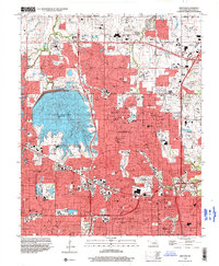 1995 Britton1999 Print · USGSThe northern suburbs of Oklahoma City are shown in detail during the mid-nineties, capturing a landscape defined by rapid residential growth and water management. Researchers can locate family sites near Rose Hill Burial Park or trace the early paths of The Village and Britton.
 - 1995 Map of Spencer, 1999 Print
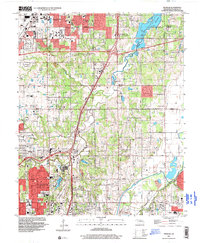 1995 Spencer1999 Print · USGSThe northeast suburbs of Oklahoma City appear in the mid-nineties as a mix of growing residential districts and established institutions. Genealogists and local historians can trace family locations near Hebrew Cem, Piper Cem, and the historic Lone Star Ch.
 - 1995 Map of Oklahoma City, 2000 Print
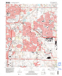
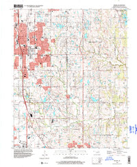
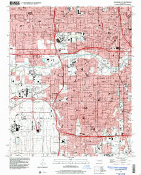 1995 Oklahoma City2000 Print · USGSOklahoma City in the mid-nineties shows a metropolis deeply integrated with its aviation and industrial hubs. Genealogists and historians can locate numerous neighborhood landmarks, from Czech Cemetery to schools like Capitol Hill High School.
 - 1995 Map of Midwest City, 2000 Print
 1995 Midwest City2000 Print · USGSMid-century urban expansion and military infrastructure define this Oklahoma County landscape in the mid-nineties. Researchers can locate family landmarks like Sunnylane Cemetery, the sprawling Tinker Air Force Base, and schools like Douglass High Sch.
 - 1995 Map of Moore, 2000 Print
 1995 Moore2000 Print · USGSThe growing corridors between Moore and Oklahoma City are captured here in the mid-nineties during a period of significant suburban expansion. Genealogists and local historians can locate early institutions like Smith Cem, Brookside Chapel, and the settlement of Hollywood Corners.
End of results
Showing maps 1-7 of 7
Top cities near Oklahoma City
- Norman historical maps
- Edmond historical maps
- Midwest City historical maps
- Moore historical maps
- Del City historical maps
- Bethany historical maps
See more
Top neighborhoods of Oklahoma City
- Witcher historical maps
- Green Pastures historical maps
- Flynn historical maps
- Wheatland historical maps
- Poole historical maps
- Stella historical maps
See more
Frequently asked questions
- What are the different types of historical maps available for Oklahoma City?
- What is the oldest map of Oklahoma City?
- Where can I purchase historical maps of Oklahoma City for my home or office?
- Where can I download high-res historical maps of Oklahoma City?
- Are there historical topographic maps available for Oklahoma City?
- Is there historical aerial imagery available for Oklahoma City?
- Where are historical maps of Oklahoma City sourced from?