1800s (19th Century) Maps of Oklahoma City, Oklahoma
Explore 7 historic maps of Oklahoma City from the 1800s (19th Century). These maps offer a rare glimpse into what life looked like during the 1800s — showing old roads, neighborhoods, homes, and landmarks that have changed or disappeared over time.
Whether you're researching your family's past, planning a metal detecting trip, or studying how Oklahoma City's landscape evolved across the 1800s, these high-resolution maps are a powerful tool for exploring the history of this region.
- Focus on a specific era: All maps on this page are from the 1800s, giving you a focused view of this time period.
- See what’s changed: Compare century-old streets, trails, and buildings to today's modern landscape using overlays and satellite layers.
- Research with precision: Use these maps for genealogy, historical research, land use analysis, or educational projects.
- View, download, or print: Maps are fully viewable online in high resolution, and can be downloaded or printed for your own records.
Start exploring Oklahoma City's history through authentic maps from the 1800s. This is your window into the past.
Oklahoma City, OK maps
(7)- 1892 Map of Moore
 1892 Moore1892 Print · USGSOklahoma Territory was still in its infancy when this survey was conducted, showing the vital rail line connecting early settlements. Genealogists and historians can trace the foundations of Moore and find long-forgotten locations like Chaddick and Berry along the Atchison Topeka and Santa Fe Rail Road.
 - 1892 Map of Edmond
 1892 Edmond1892 Print · USGSOklahoma Territory was still in its first years of settlement when this survey was conducted, showing the vital rail corridor through Edmond. Researchers can trace early township boundaries and the paths of the Atchison Topeka and Santa Fe Railroad near Waterloo and Enfield.
 - 1892 Map of Kingfisher, 1957 Print
 1892 Kingfisher1957 Print · USGSOklahoma Territory was in a state of rapid transition during the 1890s as railroads and cattle trails shared the same landscape. Researchers can trace the original Chisholm Trail alongside early settlements like Mathewson and river crossings such as Kirby Ford.
 - 1893 Map of Oklahoma City
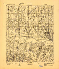
 1893 Oklahoma City1893 Print · USGSOklahoma City and the surrounding territory are captured here in the 1890s, just as the rail lines began transforming the landscape. You can trace early township developments and find the historic border between the Oklahoma territory and the Chickasaw Nation near Walden and Clancy.
 - 1893 Map of Minco
 1893 Minco1893 Print · USGSIndian Territory and the Chickasaw Nation lands meet at the turn of the century along the Canadian River. Genealogists can trace early homesteading patterns near Minco and along the Chicago Rock Island and Pacific Rail Road.
 - 1895 Map of Kingfisher
 1895 Kingfisher1895 Print · USGSOklahoma Territory during the mid-1890s reveals a rapidly developing frontier defined by river crossings and expanding rail lines. Genealogists and historians can trace the early foundations of Kingfisher, Elreno, and Yukon alongside historic river crossings like Gould Ford.4 unique versions available
 - 1898 Map of Purcell
 1898 Purcell1898 Print · USGSOklahoma and Indian Territory are captured at the end of the century during a period of rapid regional expansion. Genealogists and historians can trace the early rail alignment of the G C and S F R R as it passes through Purcell near Walnut Creek.
End of results
Showing maps 1-7 of 7
Top cities near Oklahoma City
- Norman historical maps
- Edmond historical maps
- Midwest City historical maps
- Moore historical maps
- Del City historical maps
- Bethany historical maps
See more
Top neighborhoods of Oklahoma City
- Witcher historical maps
- Green Pastures historical maps
- Flynn historical maps
- Wheatland historical maps
- Poole historical maps
- Stella historical maps
See more
Frequently asked questions
- What are the different types of historical maps available for Oklahoma City?
- What is the oldest map of Oklahoma City?
- Where can I purchase historical maps of Oklahoma City for my home or office?
- Where can I download high-res historical maps of Oklahoma City?
- Are there historical topographic maps available for Oklahoma City?
- Is there historical aerial imagery available for Oklahoma City?
- Where are historical maps of Oklahoma City sourced from?