Old Maps of Foraker, Oklahoma for Genealogy
Trace your family roots with 16 historic maps of Foraker. These high-res maps reveal old neighborhoods, homesites, landmarks, and streets — helping you uncover where your ancestors lived and how the area evolved over time.
- Explore historic neighborhoods: Identify where your relatives may have lived in the 1800s or 1900s.
- Compare maps over time: Trace the changes in streets, buildings, and landmarks for multi-generational research.
- Perfect for genealogy & ancestry research: Used by family historians and researchers to map out lineage and migration.
These maps are an incredible resource for exploring your personal connection to Foraker's past.
Foraker, OK maps
(16)- 1916 Map of Foraker
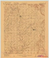 1916 Foraker1916 Print · USGSNorthern Osage County is captured here just before the First World War, showing the ranching and rail landscape of the Oklahoma-Kansas border. Family historians can locate rural landmarks like Red Eagle School, Grainola, and the Midland Valley railroad.2 unique versions available
 - 1955 Map of Enid, 1966 Print
 1955 Enid1966 Print · USGSNorth-central Oklahoma's transition from open plains to the blackjack hills of the Osage Indian Reservation is captured in the mid-1950s. Researchers can trace the development of the Naval Reserve Oil Field, the grounds of Vance AFB, and the early footprints of Tulsa and Stillwater.4 unique versions available
 - 1958 Map of Enid
 1958 Enid1958 Print · USGSNorthern Oklahoma is mapped here in the late fifties, showcasing a dense network of petroleum production and historic tribal lands. Researchers can trace the legacy of the Osage Indian Reservation, early energy hubs like the Cushing Oil Field, and the Chilocco Indian Agricultural School.2 unique versions available
 - 1973 Map of Foraker North, 1975 Print
 1973 Foraker North1975 Print · USGSOsage County ranching and oil lands appear here in the early seventies as they span the Kansas-Oklahoma state line. Researchers can trace family roots at St Johns Cem or locate historical infrastructure like the Adams Ranch Airport and the Foraker Field.
 - 1973 Map of Foraker South, 1975 Print
 1973 Foraker South1975 Print · USGSOsage County ranching and the petroleum industry define this prairie landscape in the early seventies. Genealogists and historians can trace family roots at Foraker Cem or locate the Codding Cattle Research Airport near the historic Old Railroad Grade.
 - 1985 Map of Pawhuska, 1986 Print
 1985 Pawhuska1986 Print · USGSThe Osage Indian Reservation and its tribal capital at Pawhuska are seen here in the mid-1980s as the region's ranching and oil legacies matured. Genealogists and historians can trace family-named sites and vanished industrial tracks near Bigheart, Wynona, and Gray Horse.2 unique versions available
 - 2010 Map of Foraker South, 2010 Print
 2010 Foraker South2010 Print · USGSCovers Foraker, including Osage County, United States, and other nearby areas
 - 2010 Map of Foraker North, 2010 Print
 2010 Foraker North2010 Print · USGSCovers Foraker, including Osage County, Cowley County, and other nearby areas
 - 2012 Map of Foraker South, 2012 Print
 2012 Foraker South2012 Print · USGSCovers Foraker, including Osage County, United States, and other nearby areas
 - 2012 Map of Foraker North, 2012 Print
 2012 Foraker North2012 Print · USGSCovers Foraker, including Osage County, Cowley County, and other nearby areas
 - 2016 Map of Foraker South, 2016 Print
 2016 Foraker South2016 Print · USGSCovers Foraker, including Osage County, United States, and other nearby areas
 - 2016 Map of Foraker North, 2016 Print
 2016 Foraker North2016 Print · USGSCovers Foraker, including Osage County, Cowley County, and other nearby areas
 - 2018 Map of Foraker North, 2018 Print
 2018 Foraker North2018 Print · USGSCovers Foraker, including Osage County, Cowley County, and other nearby areas
 - 2018 Map of Foraker South, 2018 Print
 2018 Foraker South2018 Print · USGSCovers Foraker, including Osage County, United States, and other nearby areas
 - 2022 Map of Foraker South, 2022 Print
 2022 Foraker South2022 Print · USGSThe northern Osage Hills come into focus in this recent survey of the prairie ranching country. Researchers can trace rural cemetery locations and drainage systems like Foraker Cem, Potato Cr, and Salt Creek.
 - 2022 Map of Foraker North, 2022 Print
 2022 Foraker North2022 Print · USGSOsage County ranchlands meet the Kansas border in this recent survey of the prairie landscape. Researchers can locate Saint Johns Cem and trace the drainage of Elm Creek and Antelope Cr near the community of Foraker.
End of results
Showing maps 1-16 of 16
Top cities near Foraker
- Pawhuska historical maps
- Cedar Vale historical maps
- Shidler historical maps
- Burbank historical maps
- Webb City historical maps
- Grainola historical maps
Frequently asked questions
- What are the different types of historical maps available for Foraker?
- What is the oldest map of Foraker?
- Where can I purchase historical maps of Foraker for my home or office?
- Where can I download high-res historical maps of Foraker?
- Are there historical topographic maps available for Foraker?
- Is there historical aerial imagery available for Foraker?
- Where are historical maps of Foraker sourced from?