1950s Maps of Rogers County, Oklahoma
Explore 5 historic maps of Rogers County from the 1950s. These maps offer a rare glimpse into what life looked like during the 1950s — showing old roads, neighborhoods, homes, and landmarks that have changed or disappeared over time.
Whether you're researching your family's past, planning a metal detecting trip, or studying how Rogers County's landscape evolved across the 1950s, these high-resolution maps are a powerful tool for exploring the history of this region.
- Focus on a specific era: All maps on this page are from the 1950s, giving you a focused view of this time period.
- See what’s changed: Compare century-old streets, trails, and buildings to today's modern landscape using overlays and satellite layers.
- Research with precision: Use these maps for genealogy, historical research, land use analysis, or educational projects.
- View, download, or print: Maps are fully viewable online in high resolution, and can be downloaded or printed for your own records.
Start exploring Rogers County's history through authentic maps from the 1950s. This is your window into the past.
Rogers County, OK maps
(5)- 1954 Map of Tulsa
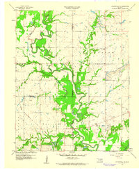
 1954 Tulsa1954 Print · USGSNortheast Oklahoma and the Ozark border are shown here during a period of massive industrial and infrastructure growth. Researchers can trace the legacy of the Tri-State Mining District and the development of major reservoirs like Grand Lake O' The Cherokees.2 unique versions available
 - 1955 Map of Mingo, 1956 Print
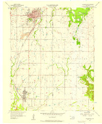
 1955 Mingo1956 Print · USGSThe eastern edges of Tulsa and the surrounding Rogers County countryside are captured here in the mid-1950s. Researchers can locate vanished landmarks and rural community centers like Garnett, the Plainview Ch, and the original footprint of Tulsa Municipal Airport.5 unique versions available
 - 1956 Map of Collinsville, 1957 Print
 1956 Collinsville1957 Print · USGSIn the mid-1950s, the corridor between Collinsville and Owasso was a landscape of growing towns and industrial coal work. Researchers can trace family sites at Ridgelawn Cem, locate the Central High Sch, or find the massive Strip Mine works.3 unique versions available
 - 1958 Map of Tulsa, 1968 Print
 1958 Tulsa1968 Print · USGSNortheast Oklahoma and the Ozark borderlands are captured here during a massive era of reservoir construction and highway expansion. Researchers can trace the mid-century footprints of Tulsa, the sprawling Lake O' the Cherokees, and historical sites like Pea Ridge National Military Park.3 unique versions available
 - 1959 Map of Collinsville NE, 1961 Print
 1959 Collinsville NE1961 Print · USGSNortheastern Oklahoma at the end of the fifties is a landscape of river bends and industrial growth. Researchers can trace the Caney River floodplain or locate rural landmarks like Zion Hill Ch and the strip mine operations.3 unique versions available
End of results
Showing maps 1-5 of 5
Top cities of Rogers County
- Claremore historical maps
- Catoosa historical maps
- Verdigris historical maps
- Chelsea historical maps
- Inola historical maps
- Justice historical maps
See more
Frequently asked questions
- What are the different types of historical maps available for Rogers County?
- What is the oldest map of Rogers County?
- Where can I purchase historical maps of Rogers County for my home or office?
- Where can I download high-res historical maps of Rogers County?
- Are there historical topographic maps available for Rogers County?
- Is there historical aerial imagery available for Rogers County?
- Where are historical maps of Rogers County sourced from?