1970s Maps of Rogers County, Oklahoma
Explore 10 historic maps of Rogers County from the 1970s. These maps offer a rare glimpse into what life looked like during the 1970s — showing old roads, neighborhoods, homes, and landmarks that have changed or disappeared over time.
Whether you're researching your family's past, planning a metal detecting trip, or studying how Rogers County's landscape evolved across the 1970s, these high-resolution maps are a powerful tool for exploring the history of this region.
- Focus on a specific era: All maps on this page are from the 1970s, giving you a focused view of this time period.
- See what’s changed: Compare century-old streets, trails, and buildings to today's modern landscape using overlays and satellite layers.
- Research with precision: Use these maps for genealogy, historical research, land use analysis, or educational projects.
- View, download, or print: Maps are fully viewable online in high resolution, and can be downloaded or printed for your own records.
Start exploring Rogers County's history through authentic maps from the 1970s. This is your window into the past.
Rogers County, OK maps
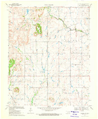
(10)- 1970 Map of Bushyhead, 1971 Print
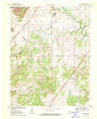 1970 Bushyhead1971 Print · USGSNorth of Claremore in the early seventies, this Rogers County landscape shows a mix of traditional prairie life and heavy industry. Genealogists can trace family landmarks like Dawes Cem and Beck Cem, while mapping the impact of the Strip Mine operations and the St Louis - San Francisco railroad.2 unique versions available
 - 1970 Map of Chelsea, 1972 Print
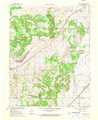
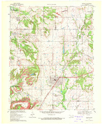 1970 Chelsea1972 Print · USGSNortheast Oklahoma's extraction landscape is on full display during the early 1970s, as coal and oil operations surround the town of Chelsea. Researchers can trace family history at Shady Grove Cem and Snider Cem or locate industrial sites like the many Strip Mines and the St Louis - San Francisco rail line.3 unique versions available
 - 1970 Map of Osage Hills, 1972 Print
 1970 Osage Hills1972 Print · USGSNortheast Oklahoma's rural landscape is captured here in the early seventies, showing the intersection of new infrastructure and established local settlements. Genealogists and historians can trace family-named sites like Vann Cem and Union Chapel, or explore the development around Harmony Star and the Will Rogers Toll Road.2 unique versions available
 - 1970 Map of Bartlesville SE, 1972 Print
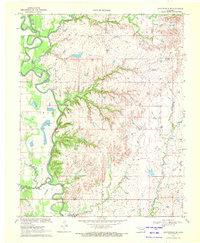 1970 Bartlesville SE1972 Print · USGSThe tri-county borderlands of northeastern Oklahoma are captured here in the early 1970s, showcasing a landscape of winding river bends and prairie creeks. Researchers can locate infrastructure of the local economy, including the Tyner Dam, a riverside Oil Well, and the Gravel Pit.2 unique versions available
 - 1970 Map of Chouteau NW, 1972 Print
 1970 Chouteau NW1972 Print · USGSNortheast Oklahoma at the start of the seventies reveals a rural landscape anchored by the Missouri Pacific railroad and family-centered landmarks. Genealogists and local historians can locate the Amish Cem, Brethren Cem, and the prominent Scaly Bark Mountain.
 - 1970 Map of White Oak, 1972 Print
 1970 White Oak1972 Print · USGSThe Cherokee Nation countryside at the start of the 1970s shows a landscape of rail-driven settlements and emerging turnpike travel. Researchers can locate family landmarks like Shawnee Cem, Condry Ch, and the workings of the Catale Oil Field.2 unique versions available
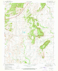
 - 1970 Map of Oologah, 1972 Print
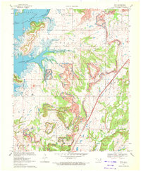
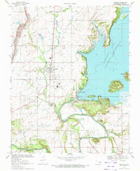 1970 Oologah1972 Print · USGSOologah and the surrounding Rogers County territory appear here just as the Oologah Reservoir redefined the local landscape. Genealogists and historians can trace the foundations of the community through the Oologah Cem, Warin Cem, and the prominent Claremore Mound.2 unique versions available
 - 1970 Map of Talala, 1972 Print
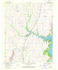 1970 Talala1972 Print · USGSRogers County at the start of the 1970s shows a landscape in transition as the Oologah Reservoir expands. Genealogists and local historians can trace the town of Talala, find the Fair View Cem, and follow the Missouri Pacific railroad.
 - 1970 Map of Winganon, 1972 Print
 1970 Winganon1972 Print · USGSRogers County is caught in a period of industrial and hydrologic change in the early 1970s as the Oologah Reservoir fills. Genealogists and local historians can locate Winganon, trace the Old RR Grade, and find many Oil Wells.
 - 1970 Map of Foyil, 1972 Print
 1970 Foyil1972 Print · USGSNortheastern Oklahoma underwent significant transformation in the early seventies as large-scale coal extraction and water projects reshaped the Rogers County countryside. Researchers can trace the sprawling strip mines and the expansion of the Oologah Reservoir alongside local sites like Oowala Cem and New Hope Ch.2 unique versions available
End of results
Showing maps 1-10 of 10
Top cities of Rogers County
- Claremore historical maps
- Catoosa historical maps
- Verdigris historical maps
- Chelsea historical maps
- Inola historical maps
- Justice historical maps
See more
Frequently asked questions
- What are the different types of historical maps available for Rogers County?
- What is the oldest map of Rogers County?
- Where can I purchase historical maps of Rogers County for my home or office?
- Where can I download high-res historical maps of Rogers County?
- Are there historical topographic maps available for Rogers County?
- Is there historical aerial imagery available for Rogers County?
- Where are historical maps of Rogers County sourced from?