1960s Maps of Sequoyah County, Oklahoma
Explore 14 historic maps of Sequoyah County from the 1960s. These maps offer a rare glimpse into what life looked like during the 1960s — showing old roads, neighborhoods, homes, and landmarks that have changed or disappeared over time.
Whether you're researching your family's past, planning a metal detecting trip, or studying how Sequoyah County's landscape evolved across the 1960s, these high-resolution maps are a powerful tool for exploring the history of this region.
- Focus on a specific era: All maps on this page are from the 1960s, giving you a focused view of this time period.
- See what’s changed: Compare century-old streets, trails, and buildings to today's modern landscape using overlays and satellite layers.
- Research with precision: Use these maps for genealogy, historical research, land use analysis, or educational projects.
- View, download, or print: Maps are fully viewable online in high resolution, and can be downloaded or printed for your own records.
Start exploring Sequoyah County's history through authentic maps from the 1960s. This is your window into the past.
Sequoyah County, OK maps
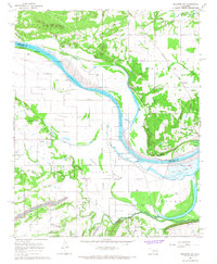
(14)- 1963 Map of Stigler NE, 1964 Print
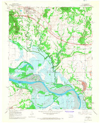
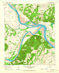 1963 Stigler NE1964 Print · USGSThe confluence of the Arkansas and Canadian rivers in the early sixties reveals a landscape of river-bottom farming and upland ridges. Genealogists can locate family burial sites like Starr Cem and Sandtown Cem or trace the Missouri Pacific rail line.3 unique versions available
 - 1964 Map of Stigler NE
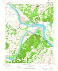 1964 Stigler NE1964 Print · USGSThe confluence of the Arkansas and Canadian rivers defined life in this corner of Oklahoma during the early sixties. Genealogists can trace family roots through numerous burial grounds like Fields Cem and Jones Cem, or locate the Stony Point Sch and McIntosh Chapel.
 - 1965 Map of Fort Smith
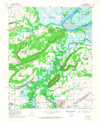
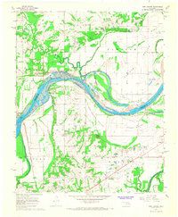
 1965 Fort Smith1965 Print · USGSEastern Oklahoma and Western Arkansas are captured here during a period of massive post-war change as new reservoirs reshaped the river valleys. Genealogists and historians can trace the rail networks of the Midland Valley RR and find established communities like Stilwell, Sallisaw, and Stigler.
 - 1966 Map of Muldrow, 1967 Print
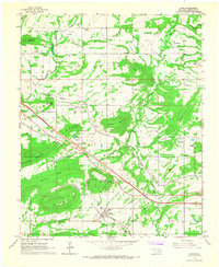
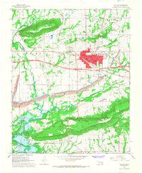
 1966 Muldrow1967 Print · USGSEastern Oklahoma in the mid-sixties reveals a landscape of growing towns and established rural crossroads. Trace family roots and local history through landmarks like the Muldrow Cemetery, Flat Rock Ford, and the Woodland Hills Church.2 unique versions available
 - 1966 Map of Gans, 1967 Print
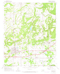
 1966 Gans1967 Print · USGSSequoyah County in the mid-sixties shows a landscape of small farming communities and family homesteads nestled between prominent ridges. Genealogists can trace family names through numerous burial sites like Seabolt Cem and Gans Cem or locate the Central High Sch.2 unique versions available
 - 1966 Map of Muldrow SW, 1968 Print
 1966 Muldrow SW1968 Print · USGSThe river-bottom country of eastern Oklahoma is captured here in the mid-1960s as industrial and agricultural patterns converge along the Arkansas River. Researchers can trace the path of the Kansas City Southern railroad through Foreman or locate family sites at Center Point Cem and Stony Point.3 unique versions available
 - 1967 Map of Fort Smith
 1967 Fort Smith1967 Print · USGSThe Arkansas River valley and the foothills of the Ozarks are captured here during a period of significant military and industrial activity. Researchers can trace the sprawling bounds of Camp Chaffee and Camp Gruber or locate vanished rail stops along the Midland Valley RR.
 - 1967 Map of Keota, 1968 Print
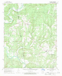
 1967 Keota1968 Print · USGSHaskell County underwent significant change in the late 1960s as the Robert S. Kerr Reservoir project prepared to flood the valley. Genealogists and historians can trace the foundations of Keota and Shoat, or locate family markers at Little Sans Bois Cem and the Midland Valley RR line.2 unique versions available
 - 1967 Map of Sallisaw, 1968 Print
 1967 Sallisaw1968 Print · USGSSallisaw and the surrounding Oklahoma river bottoms are captured here during a period of significant change in the late sixties. Researchers can trace the impact of the Robert S. Kerr Reservoir on the local landscape and locate historic sites like Buffington Cem and Badger Lee Ch.3 unique versions available
 - 1967 Map of Robert S Kerr Dam, 1968 Print
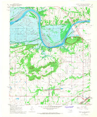 1967 Robert S Kerr Dam1968 Print · USGSIn the late 1960s, the Arkansas River valley in Haskell and Le Flore counties underwent a massive change as the Robert S Kerr Reservoir was being filled. Researchers can trace the original landscape of Cowlington and Star or locate family sites like Short Mountain Cem and Brent Cem near the new shoreline.3 unique versions available
 - 1967 Map of Vian, 1968 Print
 1967 Vian1968 Print · USGSThe Arkansas River valley is captured here in the late sixties during the construction of the Robert S. Kerr Reservoir. Researchers can trace soon-to-be-submerged lands near Sadie or locate historic rural sites like Tamaha Cem and Bethel Ch.4 unique versions available
 - 1967 Map of Fort Coffee, 1968 Print
 1967 Fort Coffee1968 Print · USGSThe Arkansas River valley undergoes a major change in the late sixties as the W. D. Mayo Lock and Dam project begins to reshape the landscape. Researchers can locate ancient and frontier history at the Spiro Mound and Skullyville, alongside rural landmarks like Lees Chapel Cem and Macedonia Ch.2 unique versions available
 - 1969 Map of Uniontown, 1971 Print
 1969 Uniontown1971 Print · USGSThe Arkansas-Oklahoma state line and the Old Indian Treaty Boundary intersect in this 1960s survey of the Ozark foothills. Researchers can trace historic family burial sites like Spears Cem and Woods Cem or locate rural landmarks such as Dripping Springs and Barcelona.3 unique versions available
 - 1969 Map of Natural Dam, 1971 Print
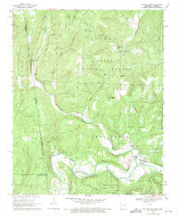 1969 Natural Dam1971 Print · USGSThe Arkansas-Oklahoma borderlands in the Ozarks appear here as a landscape of remote mountain ridges and creek-side settlements during the late sixties. You can trace old family burial grounds like Bateman Cem and Morton Cem or locate rural landmarks like Peaceful Home Ch and the Lookout Tower.3 unique versions available
End of results
Showing maps 1-14 of 14
Top cities of Sequoyah County
- Sallisaw historical maps
- Muldrow historical maps
- Roland historical maps
- Vian historical maps
- Gore historical maps
- Marble City historical maps
See more
Frequently asked questions
- What are the different types of historical maps available for Sequoyah County?
- What is the oldest map of Sequoyah County?
- Where can I purchase historical maps of Sequoyah County for my home or office?
- Where can I download high-res historical maps of Sequoyah County?
- Are there historical topographic maps available for Sequoyah County?
- Is there historical aerial imagery available for Sequoyah County?
- Where are historical maps of Sequoyah County sourced from?