1970s Maps of Baker County, Oregon
Explore 22 historic maps of Baker County from the 1970s. These maps offer a rare glimpse into what life looked like during the 1970s — showing old roads, neighborhoods, homes, and landmarks that have changed or disappeared over time.
Whether you're researching your family's past, planning a metal detecting trip, or studying how Baker County's landscape evolved across the 1970s, these high-resolution maps are a powerful tool for exploring the history of this region.
- Focus on a specific era: All maps on this page are from the 1970s, giving you a focused view of this time period.
- See what’s changed: Compare century-old streets, trails, and buildings to today's modern landscape using overlays and satellite layers.
- Research with precision: Use these maps for genealogy, historical research, land use analysis, or educational projects.
- View, download, or print: Maps are fully viewable online in high resolution, and can be downloaded or printed for your own records.
Start exploring Baker County's history through authentic maps from the 1970s. This is your window into the past.
Baker County, OR maps
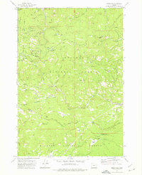
(22)- 1972 Map of Elkhorn Peak
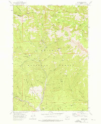
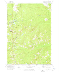
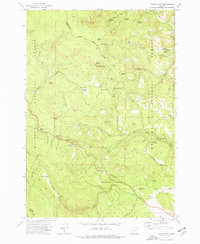
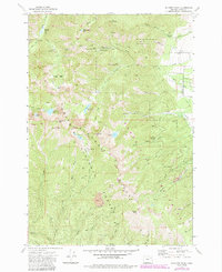 1972 Elkhorn Peak1972 Print · USGSThe Elkhorn Mountains in the early 1970s reveal a landscape of deep-cut canyons and high-altitude mines. Genealogists and historians can trace the paths of the Elkhorn Crest National Recreation Trail past the Baisley-Elkhorn Mine and Maxwell Mine.4 unique versions available
 - 1972 Map of Hereford, 1975 Print
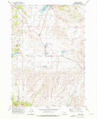
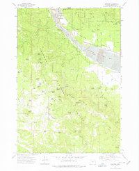
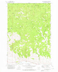
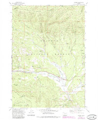
 1972 Hereford1975 Print · USGSThe Burnt River Valley in the early 1970s shows a landscape of ranching and water management near the Baker County line. Researchers can trace historic upland routes like the Happy Camp Trail or locate remote landmarks including Higgins Reservoir and Hamer Spring.
 - 1972 Map of Unity, 1976 Print
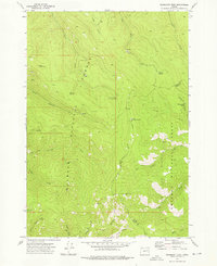
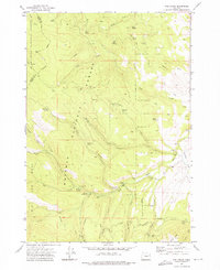
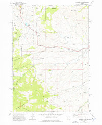
 1972 Unity1976 Print · USGSUnity and its surrounding Baker County ranch lands are detailed here during the early 1970s. Researchers can locate the Unity Cemetery and the Burnt River High School, or trace water rights along Elms Ditch and Job Creek.2 unique versions available
 - 1972 Map of Mt. Ireland, 1976 Print
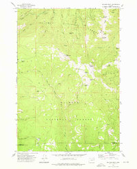
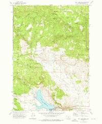
 1972 Mt. Ireland1976 Print · USGSThe Blue Mountains along the Baker and Grant county line appear here in the early 1970s, showcasing a landscape defined by historic mining and high-country trails. Researchers can locate numerous claims including the California Mine and Ophir Mine, or trace the grounds of the former Gold Center (Site).2 unique versions available
 - 1972 Map of Deardorff Mtn, 1976 Print
 1972 Deardorff Mtn1976 Print · USGSThe high ridges of the Blue Mountains are captured in the early 1970s, where Grant and Baker counties meet. Researchers can trace remote pack trails and locate numerous named water sources like Wigwam Spring, Kline Spring, and the Looney Spring Campground.2 unique versions available
 - 1972 Map of Bullrun Rock, 1976 Print
 1972 Bullrun Rock1976 Print · USGSHigh in the Blue Mountains in the early seventies, this survey captures the intersection of two national forests at the Baker and Grant county line. Researchers can trace the remote network of trails and springs like Smokey Bear Spring, Table Rock, and the headwaters of the Little Malheur River.2 unique versions available
 - 1972 Map of Bourne, 1976 Print
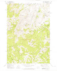
 1972 Bourne1976 Print · USGSGold mining history and timber land dominate this 1970s survey of the Blue Mountains. Trace the massive dredge tailings near Sumpter and locate remote camps like Bourne and the North Pole Mine.3 unique versions available
 - 1972 Map of Phillips Lake, 1976 Print
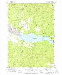 1972 Phillips Lake1976 Print · USGSPhillips Lake and the surrounding Whitman National Forest are shown in the early seventies as a landscape shaped by both recreation and old industry. Researchers can trace the Sumpter Valley Railroad Grade and locate historic sites like McEwen and the Cem among the extensive Dredge Tailings.2 unique versions available
 - 1972 Map of Rock Creek, 1976 Print
 1972 Rock Creek1976 Print · USGSNorth Powder Valley is shown in the early 1970s, revealing a complex landscape of irrigation ditches and timber heritage. Researchers can locate the Yankee Sawmill (Site), the Muddy Creek Sch, and geothermal Fisher Hot Springs.2 unique versions available
 - 1972 Map of Sumpter, 1976 Print
 1972 Sumpter1976 Print · USGSSumpter and the high valleys of the Blue Mountains are captured here in the early 1970s, revealing a landscape defined by gold-dredging history. Trace the sprawling Dredge Tailings along the Powder River or follow the Old Railroad Grade into the timber of Whitman National Forest.2 unique versions available
 - 1972 Map of Greenhorn, 1976 Print
 1972 Greenhorn1976 Print · USGSThe high country of the Blue Mountains comes into focus in the early 1970s, revealing a landscape deeply marked by its mining and timber heritage. Genealogists and historians can trace the remnants of Robinsonville, the Old Railroad Grade, and dozens of lode mines like the IXL Mine.2 unique versions available
 - 1972 Map of Beaverdam Creek, 1976 Print
 1972 Beaverdam Creek1976 Print · USGSBaker County's high-desert forest and river country come to life in this early 1970s survey. Researchers can trace the Burnt River valley floor to find Hereford and the Fleetwood Cem, or explore the cattle-range history at Hudspeth Cow Camp.3 unique versions available
 - 1972 Map of Rail Gulch, 1976 Print
 1972 Rail Gulch1976 Print · USGSEastern Oregon's timbered interior is captured here in the early seventies, where the Malheur and Whitman National Forests meet. Researchers can trace historic mining operations at Bullrun Mine and locate recreational hubs like the Elk Creek Campground.2 unique versions available
 - 1972 Map of Unity Reservoir, 1976 Print
 1972 Unity Reservoir1976 Print · USGSThe Baker County high country in the early seventies centers on the vital waters of Unity Reservoir. Researchers can trace the water-rights history of Martins Mill or locate the historic King Ranch and a remote ridge-top Cem.2 unique versions available
 - 1972 Map of Anthony Lakes, 1976 Print
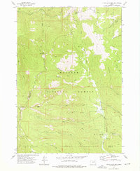
 1972 Anthony Lakes1976 Print · USGSHigh in the Blue Mountains during the early 1970s, this area shows a landscape of alpine lakes and mining history at the meeting point of three counties. Researchers can locate the Loy Mine, trace the North Fork Powder River, and explore remote basins like Cunningham Cove.2 unique versions available
 - 1972 Map of Rastus Mtn, 1976 Print
 1972 Rastus Mtn1976 Print · USGSEastern Oregon mining and forest lands are captured in the early 1970s at the meeting point of Baker and Malheur counties. Researchers can trace historic water routes like the Eldorado Ditch and locate remote sites such as the Thomason Mine and Rastus Camp Spring.2 unique versions available
 - 1972 Map of Eldorado Pass, 1976 Print
 1972 Eldorado Pass1976 Print · USGSThe high divide of the Oregon backcountry is captured here in the early 1970s as it straddles the county line at Eldorado Pass. Researchers can trace old livestock infrastructure at Ironside C&H Corrals, follow the Old Indian Reservation Boundary, or locate the remote Landing Strip.2 unique versions available
 - 1972 Map of Little Baldy Mnt., 1976 Print
 1972 Little Baldy Mnt.1976 Print · USGSThe high country of the Blue Mountains is mapped here in the early 1970s, showcasing the remote boundary between the Malheur and Whitman forests. Trace historical pack routes like the Little Baldy Trail or locate the Short Creek Forest Service Station.2 unique versions available
 - 1972 Map of Pogue Point, 1976 Print
 1972 Pogue Point1976 Print · USGSHigh ridges along the Baker and Grant county line are captured here in the early 1970s, showcasing the intersection of three major national forests. Researchers can trace historic fire lookouts like Pogue Point Lookout Tower and early recreational sites such as Wetmore Campground or Summit Meadow.2 unique versions available
 - 1972 Map of Whitney, 1985 Print
 1972 Whitney1985 Print · USGSThe North Fork Burnt River valley in the early seventies shows a landscape shaped by logging and gold dredging. Researchers can trace the Old Railroad Grade past the Clifford townsite, the local Cem, and historic operations like the Ranes & Borger Mine.
 - 1978 Map of John Day, 1997 Print
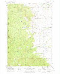
 1978 John Day1997 Print · USGSEastern Oregon in the late 1970s shows a landscape defined by timber, mining, and high-desert hydrology. Researchers can trace the legacy of the Standard Mine, the route of the Oregon and Northwestern Railroad, and the remote outposts of Seneca and Prairie City.2 unique versions available
 - 1979 Map of La Grande, 1980 Print
 1979 La Grande1980 Print · USGSNorthwestern Oregon’s mountain corridors are captured here in the late seventies, showing the rail and river networks through the Blue Mountains. Trace the Old Emigrant Road, locate the Aurelia Mine, or explore the Starkey Experimental Forest.2 unique versions available
End of results
Showing maps 1-22 of 22
Top cities of Baker County
- Baker City historical maps
- Huntington historical maps
- Haines historical maps
- Halfway historical maps
- Richland historical maps
- Sumpter historical maps
See more
Frequently asked questions
- What are the different types of historical maps available for Baker County?
- What is the oldest map of Baker County?
- Where can I purchase historical maps of Baker County for my home or office?
- Where can I download high-res historical maps of Baker County?
- Are there historical topographic maps available for Baker County?
- Is there historical aerial imagery available for Baker County?
- Where are historical maps of Baker County sourced from?