1970s Maps of Crook County, Oregon
Explore 2 historic maps of Crook County from the 1970s. These maps offer a rare glimpse into what life looked like during the 1970s — showing old roads, neighborhoods, homes, and landmarks that have changed or disappeared over time.
Whether you're researching your family's past, planning a metal detecting trip, or studying how Crook County's landscape evolved across the 1970s, these high-resolution maps are a powerful tool for exploring the history of this region.
- Focus on a specific era: All maps on this page are from the 1970s, giving you a focused view of this time period.
- See what’s changed: Compare century-old streets, trails, and buildings to today's modern landscape using overlays and satellite layers.
- Research with precision: Use these maps for genealogy, historical research, land use analysis, or educational projects.
- View, download, or print: Maps are fully viewable online in high resolution, and can be downloaded or printed for your own records.
Start exploring Crook County's history through authentic maps from the 1970s. This is your window into the past.
Crook County, OR maps
(2)- 1970 Map of Crescent, 1973 Print
 1970 Crescent1973 Print · USGSCentral Oregon in the early seventies reveals a landscape of volcanic peaks and timber outposts connected by the Southern Pacific rail line. Researchers can trace the layout of Christmas Valley, locate Cabin Lake Ranger Station, and explore the geological footprint of Newberry Crater.
 - 1972 Map of Wolf Mountain, 1976 Print
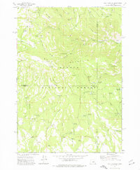 1972 Wolf Mountain1976 Print · USGSThe high country of central Oregon is mapped here in the early seventies, centered on the lookout atop Wolf Mountain. Trace historic backcountry access via the Black Canyon Trail and remote camps like Mud Springs Campground.2 unique versions available
End of results
Showing maps 1-2 of 2
Top cities of Crook County
Frequently asked questions
- What are the different types of historical maps available for Crook County?
- What is the oldest map of Crook County?
- Where can I purchase historical maps of Crook County for my home or office?
- Where can I download high-res historical maps of Crook County?
- Are there historical topographic maps available for Crook County?
- Is there historical aerial imagery available for Crook County?
- Where are historical maps of Crook County sourced from?