1940s Maps of Crook County, Oregon
Explore 3 historic maps of Crook County from the 1940s. These maps offer a rare glimpse into what life looked like during the 1940s — showing old roads, neighborhoods, homes, and landmarks that have changed or disappeared over time.
Whether you're researching your family's past, planning a metal detecting trip, or studying how Crook County's landscape evolved across the 1940s, these high-resolution maps are a powerful tool for exploring the history of this region.
- Focus on a specific era: All maps on this page are from the 1940s, giving you a focused view of this time period.
- See what’s changed: Compare century-old streets, trails, and buildings to today's modern landscape using overlays and satellite layers.
- Research with precision: Use these maps for genealogy, historical research, land use analysis, or educational projects.
- View, download, or print: Maps are fully viewable online in high resolution, and can be downloaded or printed for your own records.
Start exploring Crook County's history through authentic maps from the 1940s. This is your window into the past.
Crook County, OR maps
(3)- 1946 Map of Eagle Rock, 1963 Print
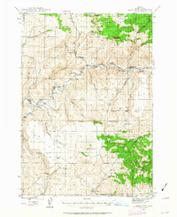 1946 Eagle Rock1963 Print · USGSCrook County ranching culture is captured here in the mid-1940s, showing a landscape defined by the Crooked River canyon. Researchers can trace historic property boundaries and family landmarks like Shorty Davis Ranch, Kizer Ranch, and the Bailey Sch.2 unique versions available
 - 1948 Map of Eagle Rock
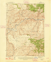 1948 Eagle Rock1948 Print · USGSCrook County ranching life in the late 1940s is centered here on the winding Crooked River and the high country of the Maury Mountains. Researchers can trace old property boundaries and local landmarks like the Bailey Sch and numerous family holdings including Way Ranch and Bolletto Ranch.2 unique versions available
 - 1948 Map of Ochoco Reservoir, 1956 Print
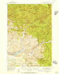 1948 Ochoco Reservoir1956 Print · USGSCovers Crook County, including United States, Oregon, and other nearby areas
End of results
Showing maps 1-3 of 3
Top cities of Crook County
Frequently asked questions
- What are the different types of historical maps available for Crook County?
- What is the oldest map of Crook County?
- Where can I purchase historical maps of Crook County for my home or office?
- Where can I download high-res historical maps of Crook County?
- Are there historical topographic maps available for Crook County?
- Is there historical aerial imagery available for Crook County?
- Where are historical maps of Crook County sourced from?