1960s Maps of Crook County, Oregon
Explore 25 historic maps of Crook County from the 1960s. These maps offer a rare glimpse into what life looked like during the 1960s — showing old roads, neighborhoods, homes, and landmarks that have changed or disappeared over time.
Whether you're researching your family's past, planning a metal detecting trip, or studying how Crook County's landscape evolved across the 1960s, these high-resolution maps are a powerful tool for exploring the history of this region.
- Focus on a specific era: All maps on this page are from the 1960s, giving you a focused view of this time period.
- See what’s changed: Compare century-old streets, trails, and buildings to today's modern landscape using overlays and satellite layers.
- Research with precision: Use these maps for genealogy, historical research, land use analysis, or educational projects.
- View, download, or print: Maps are fully viewable online in high resolution, and can be downloaded or printed for your own records.
Start exploring Crook County's history through authentic maps from the 1960s. This is your window into the past.
Crook County, OR maps
(25)- 1961 Map of Delintment Lake, 1962 Print
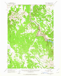
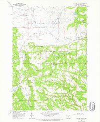
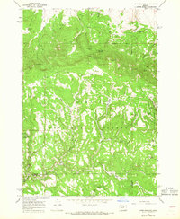
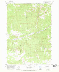
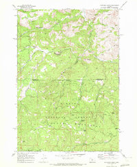
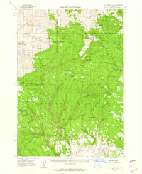 1961 Delintment Lake1962 Print · USGSHigh in the Ochoco Mountains during the early sixties, this area centered on Delintment Lake was a hub for forest management and back-country recreation. Researchers can locate remote sites like the Buck Spring Guard Sta, trace trails past Donnelly Butte, and find family-named landmarks like Williams Reservoir.2 unique versions available
 - 1962 Map of Oneil, 1963 Print
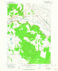
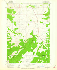
 1962 Oneil1963 Print · USGSCrook County ranch lands were defined by irrigation and river crossings in the early sixties as the high desert landscape began to modernize. Researchers can trace historic family routes along Huston Road and identify specific landmarks like the Crooked River Gorge and Forest Crossing.2 unique versions available
 - 1962 Map of Huston Lake, 1963 Print
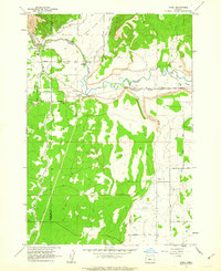
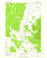
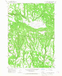
 1962 Huston Lake1963 Print · USGSThe Prineville Valley in the early 1960s reveals a landscape of high-desert agriculture and industrial infrastructure. Researchers can trace the City of Prineville Railway as it parallels the Crooked River or locate family-named sites like Myers Butte.
 - 1962 Map of Prineville, 1963 Print
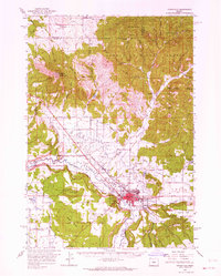
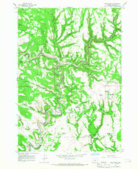
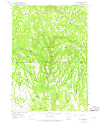
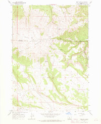
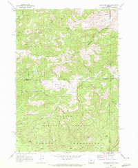
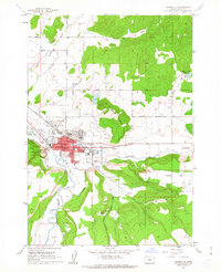 1962 Prineville1963 Print · USGSPrineville and the surrounding high desert valleys are shown in detail during the early sixties, highlighting a landscape defined by river irrigation and central Oregon ranching life. Researchers can trace the town's development through landmarks like the Courthouse, Ochoco Sch, and the Pioneer Memorial Hospital.
 - 1962 Map of Powell Buttes, 1963 Print
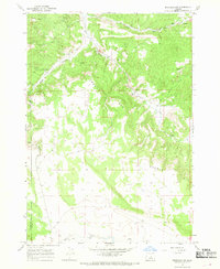
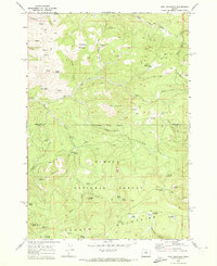
 1962 Powell Buttes1963 Print · USGSThe Crooked River valley in the early sixties shows a landscape transformed by water management and ranching. Genealogists and historians can locate established holdings like Red Cloud Ranch, the new Prineville Reservoir, and the complex Central Oregon Canal system.2 unique versions available
 - 1962 Map of Powell Butte, 1963 Print
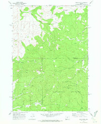
 1962 Powell Butte1963 Print · USGSThe high desert plains of Crook County are captured here in the early sixties as irrigation transformed the landscape. Researchers can trace historic water routes like the Central Oregon Canal and find family-named landmarks such as Shumway Lake and Picket Spring.3 unique versions available
 - 1962 Map of Gray Butte, 1963 Print
 1962 Gray Butte1963 Print · USGSJefferson County ranching and water management are mapped in the early sixties as irrigation reaches the high desert. Local researchers can trace family-named water sources like Rodman Spring and visit the site of the Lone Pine Sch or Gray Butte Cem.2 unique versions available
 - 1962 Map of Prineville, 1964 Print
 1962 Prineville1964 Print · USGSCentral Oregon in the early 1960s shows a landscape of river-valley agriculture and rugged uplands centering on the growing city of Prineville. Genealogists and local historians can trace rural infrastructure from Lamonta to the Upper McKay Sch and the various Cinder Pits dotting the volcanic buttes.2 unique versions available
 - 1965 Map of Williams Prairie, 1967 Print
 1965 Williams Prairie1967 Print · USGSCrook County’s high-country prairies and timberlands are captured here in the mid-1960s, showing a landscape shaped by forest management and ranching. Researchers can locate remote outposts like Cold Springs Guard Station and trace local names along Arvid Nelson Road and Long Prairie Reservoir.2 unique versions available
 - 1966 Map of Keys Creek, 1968 Print
 1966 Keys Creek1968 Print · USGSCrook County’s high country is captured here in the mid-1960s, showing a remote landscape of the Ochogo National Forest. Researchers can trace old forest infrastructure and water sources like the Cold Springs Guard Station Landing Field, Arvid Nelson Road, and Paulina Reservoir.2 unique versions available
 - 1966 Map of Peterson Point, 1968 Print
 1966 Peterson Point1968 Print · USGSThe high backcountry of the Ochoco Mountains is mapped in the mid-1960s, showing a rugged landscape of volcanic flows and forest trails. Researchers can trace historic access routes like the Keeton Trail or locate isolated sites such as Lonesome Spring Campground and Packsaddle Reservoir.2 unique versions available
 - 1966 Map of Mt. Pisgah, 1968 Print
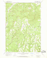
 1966 Mt. Pisgah1968 Print · USGSThe high Ochoco mountain country is captured here during the mid-sixties, showing a landscape of forest service lookouts and remote cattle camps. Researchers can locate specific range sites like Wineburger Camp, the Badger Cabin, and the lookout atop Mt Pisgah.2 unique versions available
 - 1966 Map of Derr Meadows, 1968 Print
 1966 Derr Meadows1968 Print · USGSWheeler and Crook counties meet in the high Ochoco National Forest during the mid-1960s, a period of active forest management and remote ranching. Researchers can locate the Camp Watson site, its nearby Cemetery, and the Derr Guard Station.2 unique versions available
 - 1966 Map of Little Summit Prairie, 1968 Print
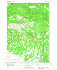
 1966 Little Summit Prairie1968 Print · USGSHigh-altitude meadows and timberlands in Crook County are captured here in the mid-1960s. Researchers can trace the historical Military Road and locate remote water sources like Hewed Log Spring and Ruby Reservoir.2 unique versions available
 - 1966 Map of Six Corners, 1968 Print
 1966 Six Corners1968 Print · USGSThe high timberlands of the Wheeler and Crook county border are captured here in the mid-1960s as forestry infrastructure was expanding. Map collectors and historians can trace the development of backcountry roads and find remote water features like Yu-ma Spring, Scab Reservoir, and the Potter Meadows high country.2 unique versions available
 - 1967 Map of Brothers NW, 1968 Print
 1967 Brothers NW1968 Print · USGSThe high plateaus of central Oregon are captured here in the late sixties at the boundary of Deschutes and Crook counties. Metal detectorists and genealogists can trace early land use through scattered mines, a prospect, and the prominent basalt edge of Rodman Rim.
 - 1967 Map of Sugarloaf Butte, 1968 Print
 1967 Sugarloaf Butte1968 Print · USGSHigh-desert volcanic peaks and canyonlands characterize this Central Oregon quadrangle during the late sixties. Researchers can trace remote Jeep Trails and water sources like Bear Creek, Ant Creek, and the springs beneath Rodman Rim.
 - 1967 Map of Brothers SW, 1968 Print
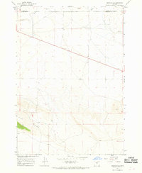 1967 Brothers SW1968 Print · USGSHigh desert life in Central Oregon during the late sixties was defined by the search for water and forage along the Crook and Deschutes line. Researchers can trace the isolated locations of Government Well, Israel Well, and the seasonal bed of the Dry River.2 unique versions available
 - 1967 Map of West Butte, 1968 Print
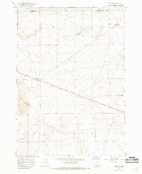
 1967 West Butte1968 Print · USGSDeschutes County's high desert terrain is captured here in the late sixties, showcasing the rugged reliance on springs and wells. Local historians and hunters can trace historic routes past Bear Ridge Well, locate early mineral Prospects, and identify watering holes like Daly Reservoir.
 - 1967 Map of Brothers, 1968 Print
 1967 Brothers1968 Print · USGSCentral Oregon ranching and aviation infrastructure are documented here during the late sixties. Trace the historical footprint of Brothers and locate specific local landmarks like Fehrenbacker Reservoir, Varco Well, and the local Landing Strip.
 - 1967 Map of Millican, 1969 Print
 1967 Millican1969 Print · USGSThe high desert of Deschutes County comes into focus during the late 1960s, showing the intersection of ranching life and volcanic geology. Genealogists and historians can locate the Millican townsite, the Landing Strip, and family-named landmarks like Coyote Well.2 unique versions available
 - 1968 Map of Dutchman Creek, 1972 Print
 1968 Dutchman Creek1972 Print · USGSThe Ochoco Mountains on the Jefferson and Crook county line appear here in the late sixties, a period defined by remote forest management. You can trace early water rights and high-country routes through Dutchman Spring, McKay Saddle, and Boxcar Flats.2 unique versions available
 - 1968 Map of Stephenson Mtn, 1972 Print
 1968 Stephenson Mtn1972 Print · USGSThe high Ochoco Mountains and national forest lands are captured here in the late sixties, where three counties converge at the edge of the wilderness. Trace old mining operations and high-country landmarks like the Lucky Strike Mine, Ludwick Cabin, and Old Stephenson Ranch.2 unique versions available
 - 1968 Map of Opal Mountain, 1973 Print
 1968 Opal Mountain1973 Print · USGSThe Ochoco Mountains of central Oregon appear here in the late sixties, showing a landscape defined by forestry and high-country ranching. Genealogists and historians can trace the sites of seasonal work at Roundup Grounds, Trout Creek Cow Camp, and the lone Lookout Tower.2 unique versions available
 - 1969 Map of Foley Butte, 1972 Print
 1969 Foley Butte1972 Print · USGSJefferson and Crook counties are captured here in the late sixties, showing a high-country landscape of the Och Oco National Forest. Researchers can locate the Lookout Tower atop Foley Butte and trace named water sources like Rainbow Trough Spring and Bug Spring.2 unique versions available
End of results
Showing maps 1-25 of 25
Top cities of Crook County
Frequently asked questions
- What are the different types of historical maps available for Crook County?
- What is the oldest map of Crook County?
- Where can I purchase historical maps of Crook County for my home or office?
- Where can I download high-res historical maps of Crook County?
- Are there historical topographic maps available for Crook County?
- Is there historical aerial imagery available for Crook County?
- Where are historical maps of Crook County sourced from?