1970s Maps of Medford, Oregon
Explore 5 historic maps of Medford from the 1970s. These maps offer a rare glimpse into what life looked like during the 1970s — showing old roads, neighborhoods, homes, and landmarks that have changed or disappeared over time.
Whether you're researching your family's past, planning a metal detecting trip, or studying how Medford's landscape evolved across the 1970s, these high-resolution maps are a powerful tool for exploring the history of this region.
- Focus on a specific era: All maps on this page are from the 1970s, giving you a focused view of this time period.
- See what’s changed: Compare century-old streets, trails, and buildings to today's modern landscape using overlays and satellite layers.
- Research with precision: Use these maps for genealogy, historical research, land use analysis, or educational projects.
- View, download, or print: Maps are fully viewable online in high resolution, and can be downloaded or printed for your own records.
Start exploring Medford's history through authentic maps from the 1970s. This is your window into the past.
Medford, OR maps
(5)- 1974 Map of Medford NW, 1978 Print
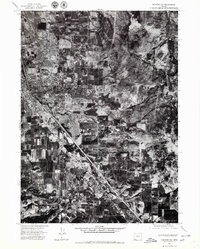
 1974 Medford NW1978 Print · USGSJackson County during the mid-seventies is captured here through detailed aerial imagery, showing the expansion of Central Point. Researchers can trace the riverbank geography of the Rogue River and locate rural landmarks like Sams Valley and Upper Table Rock.
 - 1974 Map of Medford SE, 1979 Print
 1974 Medford SE1979 Print · USGSSouthern Oregon's Bear Creek Valley comes into focus during the mid-seventies, documenting the transition from orchard land to suburban sprawl. Genealogists and local historians can trace the 1970s footprints of Medford and Phoenix as they appeared just before significant modern expansion.2 unique versions available
 - 1974 Map of Medford NE, 1979 Print
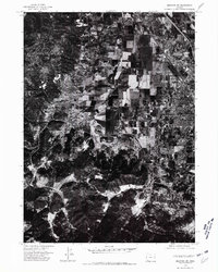
 1974 Medford NE1979 Print · USGSJackson County is captured during the mid-seventies in this detailed orthophotomap showing the layout of the Rogue Valley. Genealogists and local historians can trace the development of Eagle Point, White City, and the crossroads at Four Corners.2 unique versions available
 - 1974 Map of Medford SW, 1981 Print
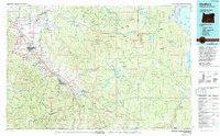
 1974 Medford SW1981 Print · USGSJackson County during the mid-seventies is captured in this detailed aerial survey of the valley and foothills. Genealogists and local historians can trace the early residential growth and agricultural layout around Central Point as it appeared decades ago.2 unique versions available
 - 1978 Map of Medford, 1994 Print
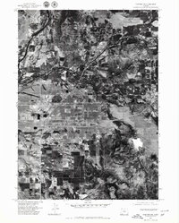
 1978 Medford1994 Print · USGSSouthern Oregon's Bear Creek Valley comes into sharp focus during the late seventies, showing the growth of Medford and Ashland along the rail lines. Local researchers can trace the development of White City, old routes through Sams Valley, and the irrigation infrastructure at Hyatt Reservoir.
End of results
Showing maps 1-5 of 5
Top cities near Medford
- Ashland historical maps
- Central Point historical maps
- Eagle Point historical maps
- White City historical maps
- Talent historical maps
- Phoenix historical maps
See more
Top neighborhoods of Medford
Frequently asked questions
- What are the different types of historical maps available for Medford?
- What is the oldest map of Medford?
- Where can I purchase historical maps of Medford for my home or office?
- Where can I download high-res historical maps of Medford?
- Are there historical topographic maps available for Medford?
- Is there historical aerial imagery available for Medford?
- Where are historical maps of Medford sourced from?