1980s Maps of Medford, Oregon
Explore 4 historic maps of Medford from the 1980s. These maps offer a rare glimpse into what life looked like during the 1980s — showing old roads, neighborhoods, homes, and landmarks that have changed or disappeared over time.
Whether you're researching your family's past, planning a metal detecting trip, or studying how Medford's landscape evolved across the 1980s, these high-resolution maps are a powerful tool for exploring the history of this region.
- Focus on a specific era: All maps on this page are from the 1980s, giving you a focused view of this time period.
- See what’s changed: Compare century-old streets, trails, and buildings to today's modern landscape using overlays and satellite layers.
- Research with precision: Use these maps for genealogy, historical research, land use analysis, or educational projects.
- View, download, or print: Maps are fully viewable online in high resolution, and can be downloaded or printed for your own records.
Start exploring Medford's history through authentic maps from the 1980s. This is your window into the past.
Medford, OR maps
(4)- 1983 Map of Sams Valley
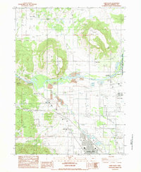 1983 Sams Valley1983 Print · USGSJackson County's Rogue River valley is captured here in the early eighties, showing a landscape of volcanic plateaus and river industry. Researchers can locate the Fort Lane (Site), the Millionaire Mine, and the rail corridor of the K D S G M R.2 unique versions available
 - 1983 Map of Eagle Point
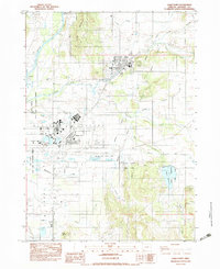 1983 Eagle Point1983 Print · USGSJackson County's landscape in the early 1980s shows the growth of settlements and water infrastructure around the Agate Desert. Researchers can trace local landmarks like the Veterans Administration Domiciliary, Agate Reservoir, and the Shot Tower.2 unique versions available
 - 1983 Map of Medford West
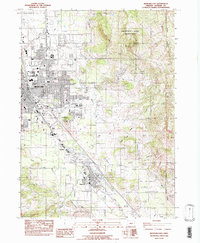
 1983 Medford West1983 Print · USGSJackson County is shown in the early eighties as the urban centers of Medford and Central Point expand toward the surrounding hills. Researchers can trace historic property boundaries in the Jacksonville Historic District or locate early mining activity near Rich Gulch and Johns Peak.
 - 1983 Map of Medford East
 1983 Medford East1983 Print · USGSThe Rogue Valley at the start of the 1980s shows a landscape of expanding settlements and vital infrastructure. Researchers can trace the development of Phoenix and Voorhies or locate regional landmarks like Roxy Ann Peak and Jefferson Sch.
End of results
Showing maps 1-4 of 4
Top cities near Medford
- Ashland historical maps
- Central Point historical maps
- Eagle Point historical maps
- White City historical maps
- Talent historical maps
- Phoenix historical maps
See more
Top neighborhoods of Medford
Frequently asked questions
- What are the different types of historical maps available for Medford?
- What is the oldest map of Medford?
- Where can I purchase historical maps of Medford for my home or office?
- Where can I download high-res historical maps of Medford?
- Are there historical topographic maps available for Medford?
- Is there historical aerial imagery available for Medford?
- Where are historical maps of Medford sourced from?