Old Maps of Klamath County, Oregon for Academic Research
Study the evolution of Klamath County with 844 high-resolution historic maps. Whether you're teaching, researching, or modeling changes in land use, these maps provide essential visual documentation of urban, environmental, and geographic change.
- Analyze long-term change: Track patterns in development, transportation, and natural features.
- Ideal for environmental or urban studies: Support academic projects with primary historical map data.
- Use in the classroom or lab: Educators and researchers rely on these maps to bring historical context to life.
These maps are a powerful tool for teaching, research, and visualizing how Klamath County has changed over the decades.
Klamath County, OR maps
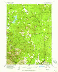
(844)- 1886 Map of Alturas
 1886 Alturas1886 Print · USGSNortheastern California at the close of the nineteenth century was a territory of high-desert basins and isolated outposts. Researchers can trace early township developments and strategic sites like Fort Bidwell, the remote Old Indian Villages, and the mining camp at Hayden Hill.
 - 1886 Map of Modoc Lava Bed
 1886 Modoc Lava Bed1886 Print · USGSNortheastern California is surveyed here in the years following the Modoc War, showing the volcanic terrain of the Modoc Lava Bed and early river settlements. Trace pioneer history through Modoc Rifle Pits, a Ferry on the Pit River, and old outposts like Bieber and Lookout.
 - 1889 Map of Klamath
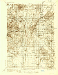
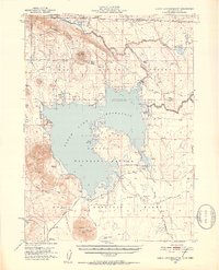
 1889 Klamath1889 Print · USGSSouthern Oregon in the late nineteenth century is a land of vast marshes and emerging frontier towns like Linkville. Historians can trace early government outposts at Ft. Klamath and Yainax Agency or locate family-named sites like Applegate Spr. and Olene.
 - 1891 Map of Ashland
 1891 Ashland1891 Print · USGSSouthern Oregon's Rogue River Valley was undergoing rapid transformation in the late nineteenth century as rail lines connected its emerging towns. Genealogists and historians can trace early property and settlement patterns near Jacksonville, Medford, and the pristine Crater Lake basin.
 - 1892 Map of Modoc Lava-Bed
 1892 Modoc Lava-Bed1892 Print · USGSNortheastern California's volcanic terrain is meticulously charted in the 1890s, before modern irrigation altered the great northern basins. Genealogists and historians can locate early outposts like Burgettville, the Modoc Rifle Pit, and the high-altitude Ice Cave.7 unique versions available
 - 1892 Map of Alturas
 1892 Alturas1892 Print · USGSNortheastern California at the close of the nineteenth century reveals a landscape of high-desert outposts and military history. Genealogists and historians can trace the early foundations of Fort Bidwell, Cedarville, and the remote Old Indian Villages near the Pit River.7 unique versions available
 - 1893 Map of Ashland
 1893 Ashland1893 Print · USGSSouthern Oregon in the late nineteenth century was a region of rapid change as the Oregon and California R. R. linked the valley floor. Researchers can trace the early footprints of Jacksonville, Medford, and Ashland, or locate landmarks like Crater Lake and Mt Pitt.6 unique versions available
 - 1894 Map of Klamath
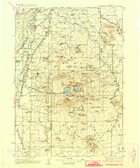
 1894 Klamath1894 Print · USGSSouthern Oregon's high desert and lake country are captured in the 1880s, revealing a landscape of remote agencies and early frontier outposts. Genealogists and historians can trace the foundations of Linkville or locate the Yainax Agency and Ft. Klamath.6 unique versions available
 - 1897 Map of Ashland, 1937 Print
 1897 Ashland1937 Print · USGSSouthern Oregon's Rogue River Valley is captured here in the late nineteenth century as the railroad began to transform local commerce. Trace the early footprints of Jacksonville and Medford, or locate remote landmarks like Wizard Island and the high peaks of the Rogue River National Forest.
 - 1917 Map of Diamond Lake
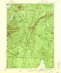
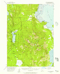
 1917 Diamond Lake1917 Print · USGSThe high Cascades of Douglas and Klamath Counties are captured here just before the First World War. Local historians and hikers can trace early forest service outposts like Higdon Ranger Sta and remote routes including the Ft Klamath Road and Bradley Trail.3 unique versions available
 - 1925 Map of Waldo Lake
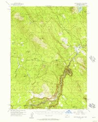
 1925 Waldo Lake1925 Print · USGSThe High Cascades near the Lane and Klamath county line are shown here in the mid-1920s as a frontier of forestry and high-country ranching. Trace early landmarks like the State Fish Hatchery, the High Prairie School, and the remote Hills Ranch.4 unique versions available
 - 1930 Map of Maiden Peak
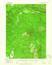
 1930 Maiden Peak1930 Print · USGSThe high volcanic plateau of central Oregon is captured in the early 1930s as a landscape of new reservoirs and forest outposts. Genealogists and historians can trace family-named sites like Caldwell Ranch or follow early travel routes like Century Drive and the Southern Pacific rail line.3 unique versions available
 - 1931 Map of Newberry Crater, 1960 Print
 1931 Newberry Crater1960 Print · USGSDeschutes County was a landscape of timber camps and volcanic wonders in the early 1930s, during a period of heavy logging. Researchers can trace the Logging RR networks, find the Vandevert Sch, and locate industrial sites like Brooks-Scanlon Camp 3.
 - 1934 Map of Maiden Peak
 1934 Maiden Peak1934 Print · USGSCentral Oregon’s high desert and timberlands are captured here in the early thirties, centered on the Crane Prairie Reservoir. Researchers can find isolated outposts like Caldwell Ranch, the Log Cabin, and Lapine at the highway junction.3 unique versions available
 - 1935 Map of Chemult
 1935 Chemult1935 Print · USGSUpper Klamath County in the mid-1930s was a landscape defined by industrial logging camps and high-desert rail sidings. Researchers can locate vanished timber operations like Pelican Bay Lumber Co Camp No 2 and remote outposts such as Rosedale and Paunina.5 unique versions available
 - 1935 Map of Newberry Crater
 1935 Newberry Crater1935 Print · USGSDeschutes County in the mid-1930s is a landscape of volcanic wonders and active timber camps. Researchers can locate remote logging outposts like Brooks-Scanlon Camp 2, rural schools including Little River Sch, and geological landmarks like Lava River Cave.3 unique versions available
 - 1941 Map of Chemult
 1941 Chemult1941 Print · USGSUpper Klamath County in the mid-1930s is a landscape of high-altitude timber camps and critical rail junctions. Genealogy researchers can trace remote family holdings and logging outposts like Hoey Ranch, Beaver Marsh, and Lumber Camp 2 along the competing railroad lines.2 unique versions available
 - 1950 Map of Mt. Dome, 1952 Print
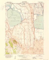 1950 Mt. Dome1952 Print · USGSUpper Klamath Basin life in the mid-century shows a landscape of reclamation and deep history at the Oregon-California border. Trace early ranching and water management at Chalk Bank Landing, the Winema Sch, and the Tulelake Tunnel.4 unique versions available
 - 1951 Map of Clear Lake Reservoir, 1952 Print
 1951 Clear Lake Reservoir1952 Print · USGSModoc County's high-desert basins and water systems are captured in the early fifties, just as the wildlife refuge and reservoir reached their modern configuration. Researchers can trace the historic Emigrant Trail or locate legacy ranching sites like McNeil Ranch and Chandler Ranch.5 unique versions available
 - 1951 Map of Tulelake, 1953 Print
 1951 Tulelake1953 Print · USGSTule Lake and the Modoc plateau are captured in the early fifties during the height of the region's agricultural development. Genealogists and historians can trace the legacy of family ranching at Old Elliot Ranch or locate the historic Battle of Lands Ranch (Site) and Carr School.4 unique versions available
 - 1954 Map of Alturas, 1968 Print
 1954 Alturas1968 Print · USGSThe Modoc Plateau and Surprise Valley appear in the mid-1950s as a landscape of remote ranching towns and vast wildlife refuges. Researchers can trace early settlements like Fort Bidwell, locate the McArthur Grain Elevator, and follow the Southern Pacific rail lines.4 unique versions available
 - 1955 Map of Lake O' Woods, 1957 Print
 1955 Lake O' Woods1957 Print · USGSThe Oregon Cascades and the shores of Upper Klamath Lake are captured here in the mid-fifties, during the height of the region's recreational growth. Researchers can locate early camps and lodges like Harriman Lodge, Long Lake Camp, and the Lake O' Woods Resort.3 unique versions available
 - 1955 Map of Surveyor Mtn, 1957 Print
 1955 Surveyor Mtn1957 Print · USGSThe Oregon-California borderlands were a hub of timber and river activity in the mid-1950s, characterized by high forest ridges and rugged canyon bends. Genealogists and historians can locate family landmarks like Spencer Cemetery, 41 Ranch, and the winding Lumber Railroad.3 unique versions available
 - 1955 Map of Rustler Peak, 1957 Print
 1955 Rustler Peak1957 Print · USGSEastern Jackson County is shown here in the mid-fifties, dominated by timber operations and family ranching during a period of transition. Researchers can locate specific family lands like Thomson Ranch and landmarks including the Copco Powerhouse and Mt Pitt Sch (Aban'd).3 unique versions available
 - 1955 Map of Hyatt Reservoir, 1957 Print
 1955 Hyatt Reservoir1957 Print · USGSSouthern Oregon and the California borderlands are mapped here in the mid-fifties, capturing a landscape of high-altitude ranching and forest management. Researchers can trace historic homesteads like Schoolhouse Ranch or the small settlement of Lincoln near its mountain millpond.3 unique versions available
Showing maps 1-25 of 844
Top cities of Klamath County
- Klamath Falls historical maps
- Altamont historical maps
- Merrill historical maps
- Chiloquin historical maps
- Malin historical maps
- Bonanza historical maps
Frequently asked questions
- What are the different types of historical maps available for Klamath County?
- What is the oldest map of Klamath County?
- Where can I purchase historical maps of Klamath County for my home or office?
- Where can I download high-res historical maps of Klamath County?
- Are there historical topographic maps available for Klamath County?
- Is there historical aerial imagery available for Klamath County?
- Where are historical maps of Klamath County sourced from?