2000-2009 Maps of Klamath County, Oregon
Explore 18 historic maps of Klamath County from 2000-2009. These maps offer a rare glimpse into what life looked like during the 2000s — showing old roads, neighborhoods, homes, and landmarks that have changed or disappeared over time.
Whether you're researching your family's past, planning a metal detecting trip, or studying how Klamath County's landscape evolved across the 2000s, these high-resolution maps are a powerful tool for exploring the history of this region.
- Focus on a specific era: All maps on this page are from the 2000s, giving you a focused view of this time period.
- See what’s changed: Compare century-old streets, trails, and buildings to today's modern landscape using overlays and satellite layers.
- Research with precision: Use these maps for genealogy, historical research, land use analysis, or educational projects.
- View, download, or print: Maps are fully viewable online in high resolution, and can be downloaded or printed for your own records.
Start exploring Klamath County's history through authentic maps from the 2000s. This is your window into the past.
Klamath County, OR maps
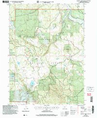
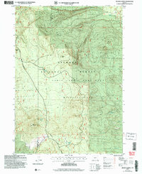
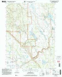
(18)- 2001 Map of Mule Hill, 2004 Print
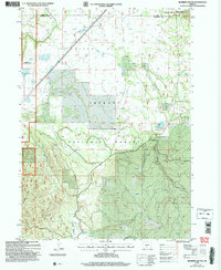
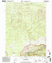 2001 Mule Hill2004 Print · USGSThe high timber and river country of the Oregon-California border comes into focus at the turn of the millennium. Genealogists and historians can trace the foundations of former outposts at Pokegama (Site) and find family history at the Way Cem near the Klamath River.
 - 2001 Map of Chicken Hills, 2004 Print
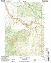
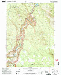 2001 Chicken Hills2004 Print · USGSThe Oregon-California borderlands along the Klamath River are shown here just after the turn of the millennium. Researchers can trace industrial infrastructure like the John C Boyle Powerplant and historical sites such as Topsy (Site).
 - 2004 Map of Ferguson Mountain
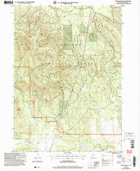
 2004 Ferguson Mountain2004 Print · USGSKlamath County timber and ranching country comes into focus in the early 2000s as the Sprague River winds toward Beatty Gap. Researchers can trace the water history of the Fremont National Forest through features like Elder Ditch and Eagle Spring.
 - 2004 Map of Bly, 2007 Print
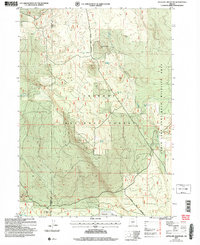
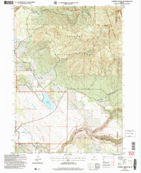
 2004 Bly2007 Print · USGSKlamath County timber and ranching lands come into focus in the early 2000s near the junction of the Sprague River forks. Researchers can trace the heritage of the wood industry at the Ivory Pine Mill (Site) and find family landmarks like Hyde Reservoir and Garner (Site).
 - 2004 Map of Horsefly Mountain, 2007 Print
 2004 Horsefly Mountain2007 Print · USGSHigh-altitude meadows and volcanic ridges define this portion of the Fremont National Forest during the early 2000s. Researchers can trace the water network of Skedaddle Spring and McKendree Reservoir or locate the site of Gerber Ranch.
 - 2004 Map of Shake Butte, 2007 Print
 2004 Shake Butte2007 Print · USGSThe Fremont National Forest in the early 2000s reveals a managed wilderness where the Sycan River meets historic travel routes. Researchers can trace the Emigrant Crossing (Site), locate the Currier Guard Station, and study the drainage of Kingry Marsh.
 - 2004 Map of Ponina Butte, 2007 Print
 2004 Ponina Butte2007 Print · USGSThe Fremont National Forest in the early 2000s shows a landscape of volcanic buttes and vital water sources. Researchers can trace high-country landmarks like Ponina Butte, the remote Foster Field, and numerous family-named springs including Petland Spring.
 - 2004 Map of Antelope Mountain, 2007 Print
 2004 Antelope Mountain2007 Print · USGSHigh-desert forest lands and volcanic buttes define the Klamath and Lake county borders at the start of the millennium. Researchers can trace remote water sources like Glades Well and historical landmarks such as Tobin Cabin or the Cinder Pit.
 - 2004 Map of Wickiup Spring, 2007 Print
 2004 Wickiup Spring2007 Print · USGSHigh desert timberlands and volcanic peaks define this Lake County region at the turn of the millennium. Researchers can locate critical water sources like Wickiup Spring and Pothole Spring or trace the fire-watch history at Bald Mountain Lookout.
 - 2004 Map of Campbell Reservoir, 2007 Print
 2004 Campbell Reservoir2007 Print · USGSIn the high-altitude landscapes of the Oregon backcountry after the turn of the millennium, this survey captures a rugged watershed of timber and lava. Researchers can trace the remote Swede Cabin, the volcanic terrain of Devils Garden, and the waters of Campbell Reservoir.
 - 2004 Map of Barnes Valley, 2007 Print
 2004 Barnes Valley2007 Print · USGSHigh desert ranching and water management in Klamath County are captured here in the early twenty-first century. Researchers can trace land use through cattle-country landmarks like Simmons Ranch, the engineering of Tull Reservoir, and the upland slopes of Juniper Mountain.
 - 2004 Map of Sandhill Crossing, 2007 Print
 2004 Sandhill Crossing2007 Print · USGSThe Fremont National Forest high country comes into focus in the early 2000s, showing the complex headwaters of the Sprague River. Researchers can locate remote high-desert landmarks like Conrad Place, the Gearhart Mountain Trail, and Sandhill Crossing.
 - 2004 Map of Riverbed Butte, 2007 Print
 2004 Riverbed Butte2007 Print · USGSThe high-desert frontier of Lake and Klamath Counties is captured here in the early 2000s, centered on the wild timberlands of the Fremont National Forest. Outdoorsmen and researchers can trace vital water sources and land use markers like Dicks Well, Klipple Lake, and the expansive Sycan Flat.
 - 2004 Map of Antler Point, 2007 Print
 2004 Antler Point2007 Print · USGSThe high timberland of the Klamath-Lake county line is captured here in the early 2000s, showcasing a landscape of vital water resources. Researchers can trace the drainage of Gerber Reservoir or locate remote landmarks like Strawberry Butte and Antler Spring.
 - 2004 Map of Lorella, 2007 Print
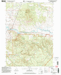
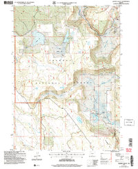
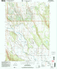 2004 Lorella2007 Print · USGSAgricultural and forest lands in Klamath County come to life in this early 2000s survey of the Lost River basin. Researchers can trace the intricate irrigation network of the West Canal and find local landmarks like Keller Bridge and Lorella.
 - 2004 Map of Gerber Reservoir, 2007 Print
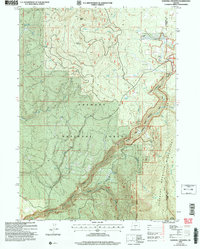
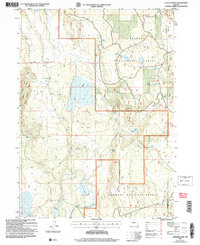
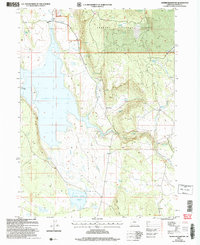 2004 Gerber Reservoir2007 Print · USGSKlamath County at the turn of the millennium features a complex network of forest water management and ancient sites. Researchers can find evidence of early history at the Petroglyphs or trace the path of the Diversion Ditch to Round Valley Reservoir.
 - 2004 Map of Goodlow Mountain, 2007 Print
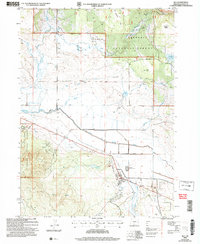
 2004 Goodlow Mountain2007 Print · USGSThe high prairie and forest land of Klamath County are meticulously detailed here at the turn of the millennium. Researchers can trace rural life and ranching history through sites like Haynesville, the local Cem, and the irrigation works of Pankey Reservoir.
 - 2004 Map of Big Hole, 2007 Print
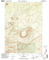 2004 Big Hole2007 Print · USGSLake County high desert terrain meets the national forest in the early 2000s, revealing a landscape defined by volcanic buttes and old travel routes. Researchers can locate the Summit Stage Station (Site) and explore the unique depression of the Big Hole (Dry Flat).
End of results
Showing maps 1-18 of 18
Top cities of Klamath County
- Klamath Falls historical maps
- Altamont historical maps
- Merrill historical maps
- Chiloquin historical maps
- Malin historical maps
- Bonanza historical maps
Frequently asked questions
- What are the different types of historical maps available for Klamath County?
- What is the oldest map of Klamath County?
- Where can I purchase historical maps of Klamath County for my home or office?
- Where can I download high-res historical maps of Klamath County?
- Are there historical topographic maps available for Klamath County?
- Is there historical aerial imagery available for Klamath County?
- Where are historical maps of Klamath County sourced from?